
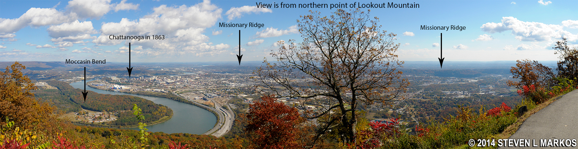
Panorama of the Chattanooga area (click to enlarge)
Missionary Ridge is located in the Chattanooga Unit of Chickamauga and Chattanooga National Military Park. It is a steep ridge that stretches from Chattanooga all the way to Chickamauga. Having lost the battle at Chickamauga, the Union Army retreated to Chattanooga with the Confederates in pursuit. However, instead of engaging the Union soldiers in a fight, the Confederates decided to surround the city and try to starve them into submission. They took up positions along Lookout Mountain, in the valleys on both sides of the mountain, and atop Missionary Ridge. This formed a semicircle around the city, and since the unoccupied areas were mountainous, Chattanooga was essentially surrounded. The blockade was in effect for two months, though a month into the siege the Union Army figured out a way to get supplies, and a month after that, having been reinforced with new men, they finally broke out and attacked Confederate positions.
A drive along Missionary Ridge not only offers great views and history, it is essential to understanding the battle. When standing at Point Lookout atop Lookout Mountain, you can see the ridge in the far distance. It looks no larger than a small hill. But once you are on Missionary Ridge, you realize that this not the case. It towers above Chattanooga, and it is easy to see how an army that occupies it can pin down anyone in the city. The only thing I can’t figure out is how you can lose a battle with positions like this, which is what the Confederates managed to do.
Missionary Ridge is now a residential area lined with houses ranging from ordinary in size and architecture to magnificent mansions overlooking the valley below.

Mansion on Missionary Ridge in Chattanooga, Tennessee
The National Park Service has retained seven parcels of land called reservations that mark significant points in the Battle for Chattanooga. Most are small, some no bigger than a street corner, while the Sherman Reservation is large enough to require a short hike. All reservations have monuments, artillery, and tablets (plaques that record which units were in the area at a particular time and day). In addition to the reservations, many houses have tablets and other markers, even cannon, in their front yards. Of course you’d have to be on foot to read them, as the road along the ridge is just two lanes with no place to park, other than at the reservations.
The Missionary Ridge tour runs along West, South and North Crest Roads. If driving the route from south to north, begin at the corner of Highway 27 and West Crest Road in Rossville, Georgia, a town just over the Georgia / Tennessee border. The Iowa Reservation is on the corner.
Follow West Crest Road until it merges with South Crest Road, then stay on South Crest. After it pass Highway 2 / 11, South Crest becomes North Crest Road. Continue until North Crest dead ends into Greenwood Road. Turn left and Greenwood soon becomes Campbell Street. The last reservation is on the corner of Campbell Street and Glass Street. The distance is approximately 7-8 miles. The route is marked with HISTORIC MISSIONARY RIDGE markers atop the street signs. Plan to spend around 2 hours to drive from Lookout Mountain and see all of the reservations.

Street signs mark the route of Missionary Ridge in Chattanooga, Tennessee
Complete details and plenty of photographs of each reservation can be found on the following web pages here on National Park Planner:
With a few exceptions, use of any photograph on the National Park Planner website requires a paid Royalty Free Editorial Use License or Commercial Use License. See the Photo Usage page for details.
Last updated on July 5, 2024


