

Deer Island map (click to enlarge)
Length: 1.3-mile loop with a short section of the Harborwalk
Time: 45 minutes
Difficulty: Moderate
The Hillside Trail is a paved path that leads up a steep hill to three overlooks on the north end of Deer Island in Boston Harbor Islands National Recreation Area. There are four access points, one at the parking lot and three that branch off of the Harborwalk on the northeast side of the island. The Hillside Trail is much more challenging than the Harborwalk, though it is still considered handicap accessible. However, unless training for the Paralympics, wheelchair-bound visitors will need some help getting up the hills.
I have a suggested loop hike that passes all three overlooks on the Hillside Trail and returns via the Harborwalk, a round trip of 1.3 miles. The first stop is the Shirley Gut Overlook, which is located on a hill just above the parking lot—you could throw a baseball to it. However, to reach it via the paved portion of the Hillside Trail requires hiking to the halfway point, then making a sharp U-turn and hiking nearly all the way back, a distance of .6 mile (imagine an upside down V). There is, however, an option to scale the hill on an earthen trail and reach the overlook in just 200 yards. Unless you are in a wheelchair, this is the only logical way to go. The trailhead is on the opposites side of the fenced-in area of high-voltage power equipment from the parking lot. I drew in the route on the satellite image below.

Earthen trail from the Deer Island parking lot to the Shirley Gut Overlook

Start of the earthen trail near the Deer Island Parking Lot to the Shirley Gut Overlook, Boston Harbor Islands National Recreation Area
The Shirley Gut Overlook gives a view of what used to be a waterway that separated Deer Island from the town of Winthrop. Over the years sand deposits made the passage unnavigable, and a hurricane in 1938 filled in the gap completely. In 1941, the Army Corps of Engineers built a permanent causeway to connect Deer Island to the mainland.

Shirley Gut Overlook on Deer Island, Boston Harbor Islands National Recreation Area

View towards Winthrop from the Shirley Gut Overlook on Deer Island, Boston Harbor Islands National Recreation Area
From the Shirley Gut Overlook, take the paved Hillside Trail south. The trail forks less than a hundred yards ahead, so stay to the right. After descending down the small hill where the overlook is located, the trail begins scaling a second hill that leads to an overlook of Logan Airport. A wayside exhibit tells about the building of the facility, which is almost entirely on landfill.

Hike up the paved Hillside Trail on Deer Island to the Logan Airport Overlook, Boston Harbor Islands National Recreation Area
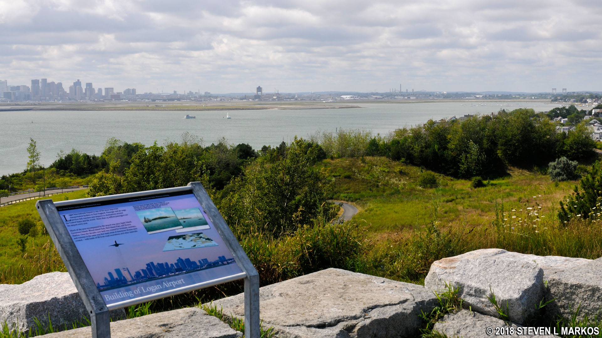
Logan Airport Overlook on Deer Island’s Hillside Trail, Boston Harbor Islands National Recreation Area
Once at the Logan Airport Overlook, you are just slightly below the peak altitude of the next hill where the Deer Island Wastewater Treatment Plant overlook is located, so you don’t have much of a climb from this point on. Being at a higher elevation, you also have views of the harbor for the rest of the way.

Westward view from Deer Island towards Long, Moon, and Spectacle islands, Boston Harbor Islands National Recreation Area
Just past the Logan Airport Overlook are a number of intersections. There are no directional signs, but all you need to know is that the next stop is near the large water tower at the very top of the hill, so head in that direction.

Path to the water tower on Deer Island, Boston Harbor Islands National Recreation Area
Just before reaching the water tower is the Wastewater Treatment Overlook. While overlooking a sewage plant doesn’t sound all that enticing, the facility is actually pretty cool.

Deer Island Wastewater Treatment Plant Overlook on the Hillside Trail, Boston Harbor Islands National Recreation Area
The most prominent feature of the Deer Island Wastewater Treatment Plant are the digesters, which are known as the eggs. This is where solid waste is broken down into sludge and methane gas. The gas is used to produce electricity for the plant, while the sludge is piped to local fast food restaurants and turned into the healthy food items they sell. What the fast food industry doesn’t need is routed to Quincy and used to make fertilizer. The next time you are eating a juicy Florida orange, be sure to thank the people of Boston.

View of the Deer Water Wastewater Treatment Plant from the top of the Hillside Trail, Boston Harbor Islands National Recreation Area

Digesters of the Deer Island Waste Water Treatment Plant in Boston
Once done at the Deer Island Wastewater Treatment Plant Overlook, you could turn around and walk back to the parking lot on the Hillside Trail, but who wants to see the same things twice? To make a nice loop out of the hike, return via the Harborwalk. To do so, continue on the paved path as it curves around the water tower. This leads downhill until dead ending into the Harborwalk. Take a left to get back to the parking lot.
Before reaching the Harborwalk, there is a grassy area with a wayside exhibit at the far end. This is the location of the Rest Haven Cemetery, an old cemetery mainly comprised of Irish immigrants who died on Deer Island when it was a quarantine center in the late 1840s and early 1850s. Though there are no tombstones present, supposedly around 800 people are buried in a mass grave at this location. The original cemetery was on the southern end of the island, but when the military took over to build Fort Dawes in 1906, the graves were relocated to this area (1908). The cemetery was somewhat forgotten until bones were dug up in 1990 during the construction of the sewage plant.

Site of a mass grave on Deer Island, Boston Harbor Islands National Recreation Area
The Harborwalk is a mainly level, paved trail that is handicap accessible. As you make your way back, you will pass two trails that branch off uphill and to the left. These are just connectors to the Hillside Trail.

Harborwalk on Deer Island in Boston Harbor
While an island that is largely taken up by a sewage treatment plant doesn’t sound like a place you’d want to be on your day off, I enjoyed the Hillside Trail as much as any trail within Boston Harbor Islands National Recreation Area. There are excellent views of the harbor, plus you can learn a few things along the way. I also suggest the Harborwalk, and to see everything you pretty much have to do them as two separate hikes.
With a few exceptions, use of any photograph on the National Park Planner website requires a paid Royalty Free Editorial Use License or Commercial Use License. See the Photo Usage page for details.
Last updated on January 12, 2024


