
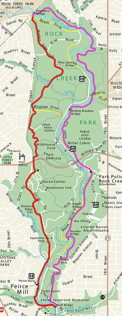
Rock Creek Park Hiking Map, Valley Trail route in pink (click to enlarge)
Length: 7 miles, one-way
Time: 4.5 hours
Difficulty: Easy to strenuous
The Valley Trail runs north to south along the eastern border of Rock Creek Park. I hiked from the southern terminus near Peirce Mill to the northern terminus near Boundary Bridge. For those who just want to hike one way, be sure to have a ride waiting at the end. I hiked back to the mill on the Western Ridge Trail. This forms a 12-mile loop, which is probably too adventurous for most people, but if you have the stamina and seven hours to kill, it’s a great hike.
If you start at the southern terminus as I did, park at Picnic Area #1 next to Peirce Mill. The parking lot is near the corner of Shoemaker and Spring of Freedom streets. From there, hike across the field towards Rock Creek and proceed south (take a right at the creek). At the far end of the picnic area is the intersection with the Melvin Hazen Trail. This is a one-way trail that leaves Rock Creek Park and runs down the center of Melvin Hazen Park until ending at Reno Road 1.1 miles away.
At this point you are on the Western Ridge Trail and need to hike another quarter mile to reach the start of the Valley Trail. There are two ways to get there. A paved multi-purpose trail that is open to both hikers and bikers continues over a large footbridge that crosses Rock Creek. This is the shortest and easiest way to go. A hikers-only trail takes a smaller footbridge over Melvin Hazin Creek. Both come out at Bluff Bridge, but the official route is along the hikers-only trail.

The hikers-only trail continues across a small footbridge

The paved, multi-purpose trail takes the larger footbridge
As you cross the bridge, notice the trail sign posted on the far side. According to the sign, a strenuous version of the hike forks to the left and a moderate version to the right. The moderate trail proceeds up to and follows a ridge above the strenuous trail, and the two parallel each other until merging back together near the Bluff Bridge at the very end of the Western Ridge Trail. The strenuous trail, which I took, is really more straight ahead than to the left, and by strenuous, the sign is not referring to an extremely hilly trail, but to the treacherous terrain that lies ahead. The trail is very narrow, filled with rocks and roots, and has a steep drop off on one side. It would be easy to trip and fall down what is close to being a cliff and end up dead in Rock Creek.

Treacherous terrain at the southern end of the Western Ridge Trail
After hiking a half mile from the parking lot, you finally reach Bluff Bridge. The multi-purpose trail passes over the bridge from the other side and continues south all the way to the Lincoln Memorial. Cross the bridge and turn left on the multi-purpose trail. This follows Rock Creek all the way back to the picnic area.

Bluff Bridge

View of Rock Creek from Bluff Bridge

Multi-purpose paved trail leads back to Picnic Area #1
Be on the lookout for an intersection marked with a Valley Trail sign. The problem with the sign is that there are no directional arrows, so it makes you believe the paved path is the Valley Trail. This is not the case. The Valley Trail is the dirt trail to the right that leads up to Beach Drive.

Turn-off for the Valley Trail
Cross Beach Drive and continue north until coming to the intersection with the Meadowlink Trail. This is only a couple of minutes’ walk, and you cross Park Road on the way. Since leaving Rock Creek, the trail has been climbing up a strenuous hill. This is because creeks, streams, and rivers are usually at the lowest point on the terrain, and whenever traveling away from one you will be heading uphill.
The trail sign at the Meadowlink intersection is also a little confusing. Both the Valley Trail and the Meadowlink Trail are listed on the sign, but the only arrow points to the left, making it appear as if both trails continue to the left. Again, this is not the case. The Valley Trail is straight ahead.

Intersection with the Meadowlink Trail
The Meadowlink Trail is C-shaped, so it heads west, curves north, and then returns east, intersecting once again with the Valley Trail about a tenth of a mile up ahead. There is no sign identifying the intersection; stay straight to remain on the Valley Trail. It is at this point that the steep hill levels out a little.
Unlike the Western Ridge Trail, which is a wide, road-like trail with a smooth surface, the Valley Trail is more like a traditional hiking trail. It is often narrow, and while fairly free of rocks and roots at the southern end, the terrain gets rougher as you hike farther north.

Typical terrain of the Valley Trail at the southern end of Rock Creek Park
There are two more intersections that you will come to before crossing Blagden Avenue about a quarter mile past the second Meadowlink Trail intersection. The first is with a trail that branches off to the right and leads to a neighborhood. After this, the Valley Trail starts heading downhill on terrain so steep that switchbacks have been formed to alleviate the difficulty of the downhill hike. Pay close attention, because at one of the curves it is possible to continue straight while the Valley Trail actually curves around to the right. The turn is marked by a sign. By then you will hear the traffic noise, and moments later you’ll be at the road.

Blagden Avenue intersection
The terrain directly north of Blagden remains moderately hilly, but nothing like the terrain south of the road. Rock Creek and Beach Drive are to the left, though they are too far away to see at this point. The trail eventually climbs high above the road, though not far enough away to escape the traffic noise. The downside to hiking at Rock Creek Park is that because it is in a heavily populated urban area, you rarely find yourself hiking in peace.

Hilly terrain north of Blagden Road
At the 1.75-mile mark on the hike is the intersection with the Theodore Roosevelt Trail. This branches off to the left and works its way south back to the intersection of Beach Drive and Blagden Road. This is also the location of Pulpit Rock, an odd shaped rock formation that overlooks Rock Creek. However, you can’t see much these days due to the trees that now block the view.

Pulpit Rock

Close-up of Pulpit Rock
The trail begins a descent back towards ground level just after passing Pulpit Rock, and you’ll soon be hiking right along the creek. You’ll pass an intersection with a trail that forks off to the right, but just remember to stick to the trail that runs closest to the creek and you can’t go wrong.

Valley Trail follows Rock Creek
The next point of interest is Boulder Bridge, which is just around a bend in the river, 2.5 miles into the hike. The Valley Trail does not cross it, but be sure to take the short detour to see it. The bridge was built in 1902 and is the location where President Theodore Roosevelt supposedly lost one of his rings. One day somebody might find it—I just hope it’s not Gollum.

Boulder Bridge
Unfortunately, Beach Drive crosses over Rock Creek on Boulder Bridge and comes between the creek and the trail, so you now get a view of the road for the next mile.

Valley Trail winds along a ridge high above Beach Drive
The Valley Trail eventually comes to a T-intersection at a set of wooden steps where it makes a sharp turn to the right. The path to the left fizzles out a hundred yards farther down.

Stairs along the Valley Trail (looking up from the bottom)
For the next mile you have an uninterrupted hike along Beach Drive and Rock Creek. This comes to an end at a massive tangle of road intersections—Beach Drive, Military Road, and Joyce Road. The trail emerges from the forest onto Beach Drive just south of the Park Police Station. Cross the street and follow the worn path that runs along Rock Creek until you get to Joyce Road. You will pass Picnic Area #5 along the way.

Park Police Station
Cross Joyce Drive and take the paved multi-purpose trail towards the Military Road overpass. The Valley Trail continues on the right side of the road immediately after the overpass. The trailhead is marked with a sign. This is 3.5 miles from the parking lot, the halfway point on the hike.

Cross Joyce Road and head for the Military Road overpass

Get back on the Valley Trail just after passing under Military Road
The Valley Trail is now a very narrow trail, and the forest changes from tall trees and a well-manicured floor into a jungle. In fact, this is the only overgrown stretch of trail that I encountered in the entire Rock Creek Park. You are bound to brush up against vegetation, so watch out for ticks. You are most likely to pick them up down around your ankles, and once they get on you they make a bee-line for your crotch. If they can’t get to that because you are wearing long pants, they’ll continue climbing until reaching your hair. Thus, check the fronts of your legs every few minutes. And if ticks aren’t bad enough, the trail immediately climbs an extremely steep hill along a series of switchbacks until eventually settling high above Beach Drive on another ridge.

Jungle-like terrain just north of Military Road
An interesting sight comes less than five minutes after hopping back onto the Valley Trail—three trees that have grown together. I saw a couple of double trees, but this is the first and only triple tree that I saw.

Three trees growing together
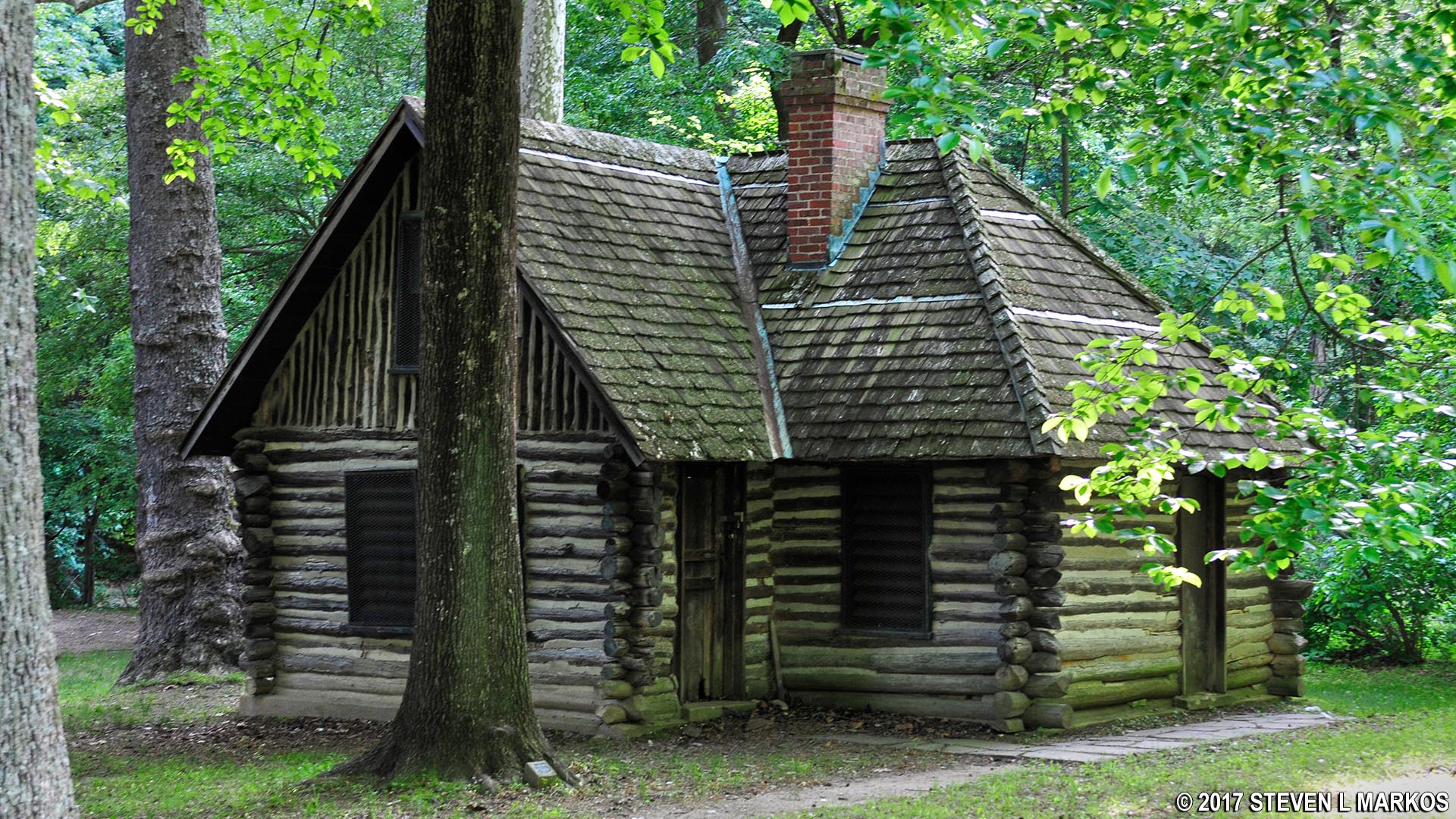
A quarter mile after passing Military Road, the jungle-like terrain disappears and the trail comes down from the ridge and runs right along the road, passing a restroom building that is open to the public. Across the street is Picnic Area #6 and the Miller Cabin. The cabin belonged to a poet named Joaquin Miller, who was a popular character in Washington. Miller lived in the cabin back in the 1880s. It was originally located on Meridian Hill and moved to this location in 1912 when Meridian Hill Park was being developed. The cabin is not open to the public due to it being unsafe to enter. In fact, it might not even be there when you hike the trail because the National Park Service plans to move it to Picnic Area #14. It is currently in a floodplain.
Miller Cabin
Not long after passing the restroom, and just about where Beach Drive crosses a bridge to get back to the west side of Rock Creek, the Valley Trail merges with a horse trail. From its southern terminus up until this point the trail has been a hikers-only trail. It is now much wider, so there is less of a chance of coming into contact with ticks. Nevertheless, keep checking yourself for the pests.
Once on the horse trail, the terrain levels out and the trail surface is as smooth as a baby’s bottom, with a few exceptions here and there. The trail now runs right along Rock Creek and is oftentimes so close that you can jump right in the water.

Valley Trail is close enough to Rock Creek to jump in
The horse trail segment only lasts a short stretch before it crosses over Rock Creek via the Rolling Meadow Bridge. At this point the Valley Trail narrows considerably and remains so for the next half mile.

Narrow path on the hikers-only section of the Valley Trail
Just south of Sherrill Drive, the trail intersects with the Whittier Trail, which leads east over to 16th Street. Prior to the intersection is a great view of some cascades on Rock Creek. You can walk right down to the water.

Cascades on Rock Creek
Just after passing under the Sherrill Drive overpass is the intersection with the Holly Trail. This forks to the right and runs along 16th Street for a stretch before intersecting with the street farther north. By this point the Valley Trail is as flat as a pancake, and it also widens quite a bit. Since the steep climb just after Military Road, the Valley Trail has turned out to be one of the easiest hikes in the park.

The Valley Trail widens near the intersection with the Holly Trail
At 5.3 miles into the hike is the intersection with a short trail that leads to the Riley Springs Bridge. It is here that the Valley Trail once again merges with a horse trail, and from here all the way to the trail’s end near the Boundary Bridge, both horseback riders and hikers share the road.

Hiker and horseback rider segment of the Valley Trail
Starting at the bridge, Rock Creek begins a long, backwards S-curve. The Valley Trail temporarily veers away from the water and begins an uphill climb deeper into the forest. The climb is not backbreaking, but you’ll certainly notice it. Towards the top of the hill is the intersection with the Pine Trail, which heads over to 16th Street near its intersection with Holly Street.
In another .3 mile the trail is back along Rock Creek, but follows high above it on a ridge for a quarter mile before gradually descending back to ground level. Be on the lookout for a stone wall that juts into the water. I’m not sure what this is, but there were a lot of mills along Rock Creek, so maybe this is a remnant of one.

Stone wall juts into Rock Creek
As it approaches the overpass for West Beach Drive, the Valley Trail follows Rock Creek very closely. At the bridge, swing to the left and pass under it. A right leads up to the road.
Once past the bridge things get really confusing because there are trails that are not on the map. A narrow, unnamed trail cuts to the right and follows Rock Creek, which would seem like a likely candidate for the Valley Trail. However, the Valley Trail actually continues straight, moving away from the creek in the process. Both trails head west, and they both come out at Boundary Bridge since that’s the only way across the creek, but I stuck with the official route. If you get confused, just remember to stay on the wide horse trail.

Typical terrain of the Valley Trail at the north end of Rock Creek Park
There is another intersection almost immediately—stay to the left and head west. For the next quarter mile the Valley Trail runs parallel to Parkside Drive, then slowly drifts away from it, leaving the traffic noise far behind. This was the first time in a while that I was hiking in silence, and I began to wonder if I made the correct turn.
The Valley Trail eventually dead ends at a T-intersection. Taking a right puts you on the Boundary Trail, which leads north to Grubb Road. The Valley Trail turns to the left. Again, it’s so quiet that it’s like being in No Man’s Land.
After hiking seven miles you finally arrive at the Boundary Bridge. Cross it and take a left and you’ll be at the parking lot in a few minutes. The trail runs right into the backside of the lot.

Boundary Bridge
If you have a ride waiting, this is the end of journey. If you plan to hike back on the Western Ridge Trail, head out to the road and you’ll see the trailhead directly across the street. It is about 5 miles back to Peirce Mill.

Northern trailhead for the Western Ridge Trail
With a few exceptions, use of any photograph on the National Park Planner website requires a paid Royalty Free Editorial Use License or Commercial Use License. See the Photo Usage page for details.
Last updated on June 30, 2020


