

Canoeing the Wilderness Waterway in Everglades National Park
Drew Boon spent eight days paddling the northern end of the Wilderness Waterway from the Gulf Coast Visitor Center to the Lostmans Five Bay backcountry campsite, a one-way distance of approximately 27 statue miles. The entire Waterway is 99 miles and runs from the Gulf Coast Visitor Center to the Flamingo Visitor Center at the southern end of the park.
BY | Drew Boon
When I was about nine years old, my dad read Lucy Salamanca’s book Lost in the Everglades to my siblings and me. The story of a lost boy’s adventures through the wilds of the Florida Everglades captured my imagination and invoked within me a desire to one day explore the Glades myself. It took me almost twenty years to get around to it, but when I finally fulfilled that goal this past February 2015, the experience was better than I had dreamed.
As I started researching for my trip, I learned that the best way to experience the Everglades is via boat, and that camping trips often involve canoes or kayaks. While there are camping areas on the mainland, they were designed for RVs and car camping, neither of which suit my fancy. When I’m camping, I enjoy seclusion and freedom, so I decided to travel part of the ninety-nine mile Wilderness Waterway, which goes through the most remote region of the United States this side of the Mississippi.
There are many websites providing information on traveling through the Everglades, and I read various accounts, but the most helpful resource was Paddling the Everglades Wilderness Waterway by Genzen and Sullivan. Another must read publication is The Wilderness Trip Planner, found on the National Park Service’s website. I also read Kjellstrom’s updated Be Expert with Map and Compass, which had a lot of helpful advice for navigating with a map and compass.
My plan was to spend nine days in the Glades, so I decided the cargo capacity of a canoe best fulfilled my needs. The easy maneuverability of a kayak would have been nice, but since my trip was going to last more than a couple of days, there was no way all of my supplies would have fit. Most people who travel in a kayak are embarking on much shorter trips. The rule of thumb for fresh water supply is one gallon per day, which meant I needed at least nine gallons. The unusual amount of activity I would be doing meant that I needed extra food, too. I ended up bringing 10 gallons of water, 30 large meals, and snacks. Other bulky items included a tent, sleeping bag, and extra clothing.
I froze eight jugs of water and put them in a forty-eight quart cooler, which left lots of little pockets for the stromboli, peanut butter sandwiches, pancakes, and chocolate I brought, and there was still ice left in the cooler seven days into the Everglades. My non-perishable food container was a hard plastic box, in which I put two more jugs of water, three boxes of Ramen noodles, marshmallows, graham crackers, a stove, stove fuel, a pot, and various other small food related items. I kept the box and cooler securely closed with a couple of bungee cords. My extra clothing, toilet paper, sleeping bag, electronics, and other water sensitive items were stuffed into a fifty-five liter waterproof bag. My tent and non-water sensitive supplies were carried in a small backpack.
Permits are required for backcountry camping, but cannot be obtained more than twenty-four hours in advance. To obtain one, visit either the Gulf Coast Visitor Center in Everglades City (on the west side of the park near Naples) or the Flamingo Visitor Center on the southeast side of the park. Permits can only be obtained in person and are issued on a first-come, first-serve basis. There is a small fee during the winter season (late November through early April), but during the summer they are free.
I was leaving from Everglades City. The Visitor Center is a two story building with the park office on the top floor and a park concessionaire on the ground floor (they are happy to give directions if needed, in addition to selling many small essential items, renting canoes and kayaks, and guiding tours). When I arrived at 9:30 AM Tuesday morning a short line had already formed at the desk. However, I didn’t have to wait more than a few minutes before someone was available to help me.
When the Ranger learned I was planning on traveling solo in a seventeen foot canoe, he looked at me like I was crazy and directed my attention to the weather forecast on the desk, which predicted strong, gusty winds for the next week. He still took the time to go over a map with me, however, showing me which direction the winds would be blowing on given days and helping me plan an efficient route.
I had a general plan in mind for where I wanted to stay, but the first site I wanted, Crooked Creek chickee, was full, so I opted for the Lopez River campground instead. This is a common problem which can generally be avoided by arriving at the Visitor Center first thing in the morning the day before you start. However, even if you beat the crowd, your chosen campgrounds may already have been filled up by people who departed days earlier, so be prepared to make spur-of-the-moment changes. After I figured everything out, I went down to the concessionaire to get my previously reserved canoe, and started loading up. It wasn’t until several days later that I realized I had made reservations for one night less than I had originally intended.
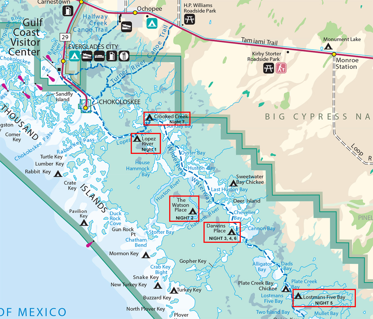
Drew Boon’s campsites (click to enlarge)
For navigation, I relied upon waterproof nautical charts and a compass. Nautical charts 11430, 11432, and 11433 cover the whole of the Wilderness Waterway, though they don’t quite cover the entire Everglades National Park. I brought along two compasses, an inexpensive Coghlans Map Compass and a more expensive Suunto M3 D/L. Curiously, the salt buildup from evaporated water caused the Suunto to lock up, but didn’t bother the Coghlans at all. Magnetic North and true North are closely synced in the Everglades, so I didn’t have to worry about declination, making navigation much easier.

Nautical charts and compasses
Navigation with a map and compass deserves its own article, and both of my compasses came with detailed instructions on navigation. In short, however, you start by finding your location on the map and determine which cardinal direction you need to travel. Then you face that direction using your compass, find a landmark in that direction, and head for it as straight as you can. When you reach that landmark, start the process over again. A landmark can be anything that stands out in some way from its surroundings. I tended to use a tall tree, but almost anything can work. Sometimes you can simply follow the shoreline, though that can add length to your trip. One of the trickier things for me was learning how sizes on the map corresponded to the real world—particularly the sizes of bays—but when I started using the map’s scale to estimate and had spent some time on the water, it became easier.
From reading Lost in the Everglades and other stories, I expected the Glades to be primarily composed of fields of tall sawgrass in shallow water. My first day of paddling through Chokoloskee Bay, the Canal, and Lopez River quickly dispelled those images. Instead of spending most of my time in narrow passageways, I was primarily traveling through large bays and rivers. The sawgrass can be found in the Shark Valley River region, but not in the northern section of the Glades where I traveled.

Sunday Bay
Most of the “land” is covered with water at high tide and is populated by dense mangrove forests. Campsites are either on covered wooden platforms out in the water called chickees or on ancient shell mounds made by Calusa Indians. These mounds are basically shellfish garbage dumps that hold years and years of shells discarded after meals. Some of these mounds grew into small mountains. All the chickees and inland sites have port-a-potties, but the sites in the keys do not (keys are the islands along the open waters of the Gulf of Mexico and are popular due to their swimming beaches).
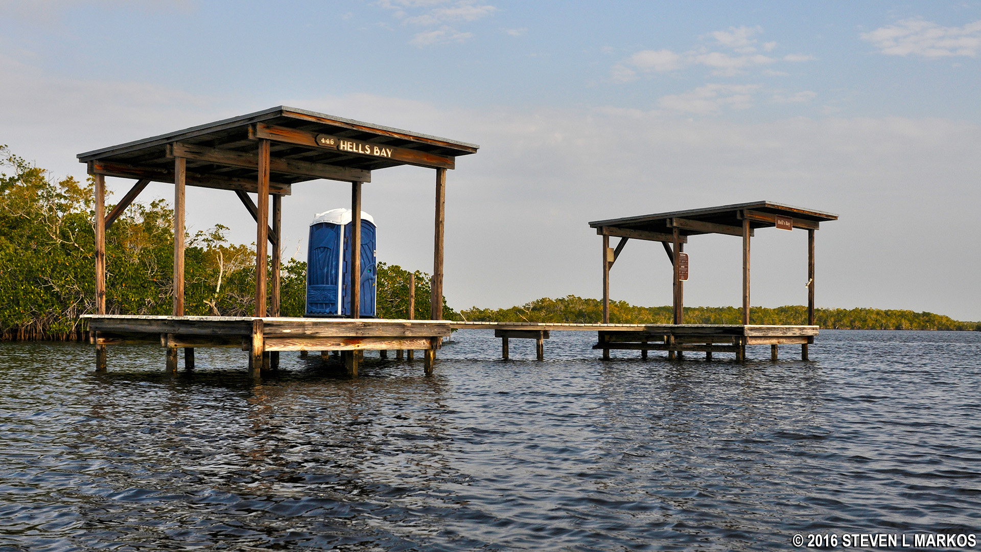
Typical chickee in the backcountry of Everglades National Park
I did paddle through a few smaller waterways, such as Alligator Creek, Plate Creek, and my favorite, Gopher Key Creek.

Gopher Key Creek’s mangrove lined shores
I only saw three alligators on my whole trip, one in Alligator Creek, and two in Gopher Key Creek. One was easily eight feet long. All of them were shy and would not let me get very close before retreating underwater into the mangrove roots.

Alligator at Gopher Creek
Guidebooks will mention how surprisingly difficult it can be to paddle against wind and tide. While the tide can be a bit difficult, no matter which way the wind is blowing it will always make paddling harder. When it’s blowing against you, it will slow you down and try to turn the canoe sideways. If it’s with you, it will still try to turn you sideways. The lighter your boat the harder it is to fight the wind, and it’s especially difficult when paddling a canoe solo. If you expect to be paddling on a windy day, one tip to keep in mind is that early mornings are generally the calmest part of the day, and starting in the dark can make a huge difference in the amount of distance you can travel. Paddling along the shore closest to the point of the wind’s origin can also provide some shelter.
Shallow water is more easily stirred up by the wind, and around the keys it’s always choppier than farther inland. The week before I went out, a couple of campers in the keys had their canoe capsized by the wind and one of the men drowned. Across wide bays, the wind piles up waves that get bigger the farther they travel. Whitewater Bay is so wide that, despite being three to four feet deep, it can become so bad on windy days that kayakers talk about hitting against the ground in the troughs between waves.
While paddling across the two-mile wide Chevelier Bay, I had the wind at my back, gusting up to thirty miles per hour. By the time I reached the peninsula halfway across, the waves were as high as the sides of my canoe and I quickly realized that if I got turned sideways into them—as the wind was constantly trying to force me—I would have capsized. I managed to get around the tip of the peninsula, where I took a break in the sheltered water before tackling the last half of the bay. The only way I was able to get across was by paddling as hard as I could at a thirty to forty-five degree angle to the direction of the wind and waves, constantly fighting to keep my canoe from turning completely sideways.
After crossing Chevelier, I was so tired that I decided to stop when I reached Darwin’s Place, only halfway to my planned destination of Lostman’s Five. I wasn’t the only one who stayed the night there unexpectedly, as the couple who shared the site with me hadn’t originally planned on it either. Just as you often have to choose alternate campsites when getting your backcountry permit, changes to travel plans once on the water due to bad weather or other unforeseen circumstances are also common. If you show up at a campsite without a reservation, if at all possible, the other campers will try to make room for you. However, if the place is full, there’s not much that can be done. Be particularly cautious about trying to show up at a chickee, for there is only room for two campers (there are only two platforms).
I spent the rest of the day reading on my Kindle and chatting with my site mates. We watched the birds in the evening as they flew back to their rookeries, saw a pod of dolphins swim by, and did some stargazing that night. I also learned how helpful my marine radio was, as it allowed me to listen to NOAA’s forecasts and make plans based on them.
The early stop threw off my intended itinerary, as it did for almost everyone paddling in the Glades at the time. I heard that four groups stayed in the Lostman’s Five campground that night, which must have been quite a crowd. I never had a problem with the sites where I stayed, despite being at the wrong ones for half my trip, since the more remote sites were not nearly in demand as much as the sites closer to Everglades City.
One of the unexpected pleasures of this trip was talking with my fellow travelers. Several people I met had spent quite a bit of time in the Glades and were able to tell me entertaining stories and give me tips about how to get the most out of my time. One night I camped with a group of fire performers, who happily demonstrated their talents. On afternoons and evenings when I was alone, I spent the time reading, watching wildlife, or exploring the shell mounds upon which I was camping. I really wish I had brought along some writing materials, as my unscripted video journals are painfully embarrassing to watch.
Another topic of interest when discussing traveling in the Everglades is that of bugs. There are two main pests that I encountered: mosquitoes and no-see-ums. Neither are particularly hardy, and if the temperature drops below 50 degrees (in the winter season, of course) they disappear. Wind and sun seem to keep them away as well. On pleasant evenings, however, as soon as dusk falls, the mosquitoes come out in force. I brought DEET and geraniol spray repellents, and had treated my clothing with permethrin beforehand. Though the sprays worked on whatever surfaces I used them, I did find a few mosquitoes flying up the back of my shirt, and had to reapply the spray every couple of hours. Supposedly ground sites are more prone to harbor animals and insects, but my worst night for mosquitoes was on the Crooked Creek chickee.
Each campsite that I visited was unique. The Lopez River campground is a small shell mound and can get rather cramped. Be careful where you pitch your tent, as lower spots can flood in high tide. I didn’t do much exploring here, but there didn’t appear to be much to see besides an old cistern. Lopez River itself is fairly busy, as it is a main thoroughfare for people traveling in and out of the Glades.

Lopez River campsite
Watson’s Place campsite is on a larger shell mound and has plenty of room for pitching tents. There is, reportedly, nearly 40 acres here that can be explored, but the trails can get rather muddy. Since I didn’t bring extra footwear with me, I didn’t go far into the woods. Besides a cistern in which “fresh” water can be found, there is a large cauldron, a piece of old machinery, and a couple of small concrete mounds left from the days of sugar cane processing.

Watson’s Place Campsite

Watson Cauldron
Darwin’s Place campsite is on a busy channel where not everyone respects the slow speed signs. This shell mound is at least an acre or two, and I spent a couple of hours tramping through the woods exploring one afternoon. You might very well see dolphins swim through the channel here in the mornings and evenings, as well as see flocks of birds traveling to and from their rookeries.

Darwin’s Place Campsite
Lostman’s Five campground is on the shore of Lostman’s Five Bay. It had the best sunset view of the places I stayed, and even my morning view was quite spectacular. I’m fairly certain I heard a couple of deer in the woods at night.

Lostman’s Caempsite

Sunset at Lostman’s

Sunrise at Lostman’s
My worst experience was on the Crooked Creek chickee. While it wasn’t necessarily bad, there was no shelter from the wind and the poorly constructed roof leaked. The mosquitoes were also ridiculously thick in the evening. The changes in water level between tides are quite drastic and make it difficult to properly secure a boat. I ended up using bungee cords to allow some give. The canoe still woke me up as water from the roof dripped into it with heavy thunks. Many canoes have capsized during the night when they drifted under a chickee in low tide, and then got trapped and forced under the water by the rising high tide. The gentlemen on the chickee adjacent to mine had a really difficult time getting out of their kayaks onto the chickee during low tide. The sunset views weren’t too bad, though.

Crooked Creek chickee
Campsites in the keys offer a few unique challenges which I did not get to experience, since I had to alter my itinerary, though I heard plenty of stories. Besides the lack of privies, they also have a bold raccoon population, which will carry off any unsecured goods, tear open water jugs, unzip tent doors, and do all of this while you are watching. Accessing the keys can also be difficult on windy days since the water becomes quite choppy. You can, however, build campfires below the high water line on the beaches, and I heard Pavilion Key is particularly beautiful.
There is rarely a lack of wildlife in the Glades for the nature enthusiast to enjoy. Besides a variety of birds, I saw dolphins, manatees, alligators, sharks, and one small snake. Birds are everywhere, dolphins play in the bays, manatees drift near Chokoloskee, sharks swim all over, alligators prefer the calmer water of creeks, and snakes are rarely spotted. Large pythons do live in the Glades, and are generally blamed for the annihilation of the mammal population, but it’s unlikely you will see one. I saw deer droppings at Darwin’s Place, and believe I heard them foraging at night there and at Lostman’s.
The Everglades is a place that requires more than one trip to appreciate, and I definitely plan on going again before too long. One day I might even try braving the summer season, with its thunderstorms, hurricanes, and hordes of mosquitoes, to see how the pioneers down there really lived. I wish I had spent more time familiarizing myself with the flora and fauna of the area beforehand so that I could have known more about what I was experiencing, but, as a fellow camper said, “That’s why you come back.”
Distances Traveled
Day one: 8 miles (Everglades City to Lopez River campground)
Day two: 11 miles (Lopez River campground to Watson’s Place campground)
Day three: 4.5 miles (Watson’s Place campground to Darwin’s Place campground)
Day four: 7 miles (Gopher Key Creek side trip and back to Darwin’s Place campground)
Day five: 6.5 miles (Darwin’s Place campground to Lostman’s Five campground)
Day six: 6.5 miles (Lostman’s Five campground to Darwin’s Place campground)
Day seven: 11.5 miles (Darwin’s Place campground to Crooked Creek chickee)
Day eight: 9 miles (Crooked Creek chickee to Everglades City)
With a few exceptions, use of any photograph on the National Park Planner website requires a paid Royalty Free Editorial Use License or Commercial Use License. See the Photo Usage page for details.
Last updated on August 17, 2024


