
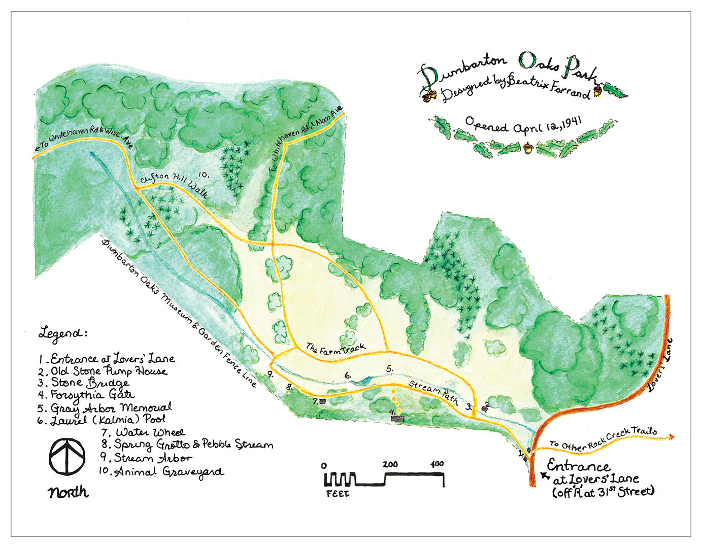
Dumbarton Oaks Park map (click to enlarge)
For directions to the park, see the main Dumbarton Oaks Park web page here on National Park Planner.
Length: .8-mile loop
Time: 30 minutes
Difficulty: Easy
There are a number of trails in Dumbarton Oaks Park, most all of which can be covered on a short loop hike. My plan of action was to start off on the southernmost trail where all of the historic features are located and return back on the Farm Track. There are two side trails that lead up to Whitehaven Road, but these are simply entrances into the park for those working or living nearby. There is no reason whatsoever to hike them unless you came from Whitehaven Road.
A brochure box that contains trail maps is located just outside the gate. Be sure to pick up a copy because it not only provides directions, it also has information about historical features you will see along the way. If you don’t have any use for the map after the hike, please return it to the box. When I hiked the trail I got the last one, and without it I wouldn’t have even known where to go.

Entrance to Dumbarton Oaks Park
The entrance to the park is at the end of Lover’s Lane, a side street located halfway between Avon and 31st streets. The current wooden gates are reproductions of the original gates built in 1941 when the park opened. These were designed by Beatrix Farrand, the lady who landscaped both the natural area and the formal gardens for the estate’s owners, Robert and Mildred Bliss.
As you walk to the first intersection you will pass a stone structure on your right. This is a pump house that was used by farmers who owned the property before the Blisses. It dates to some time in the 1800s.

Pump House
The southern half of the loop is called the Stream Path because it follows a small stream for its entire length. Here you will find a number of man-made cascades and small ponds.

The Stream Path
At the first intersection, which is the start of the loop, stay straight and cross over a stone bridge, a Bliss-era replacement of an earlier bridge from the 1800s. Shortly after beginning the loop is a side trail on your left that leads up to Dumbarton Oaks Museum and Gardens (not part of the Rock Creek Park). The arched gate you see is called the Forsythia Gate.

Stone Bridge
The next point of interest is a memorial to the first grounds keeper of the Bliss Estate. The memorial plaque is now missing.

Memorial to the first Dumbarton Oaks grounds keeper
Just after the memorial are two small dams that create a couple of ponds, the larger of which is called the Laurel Pool.

Two man-made dams built to form decorative pools of water

Laurel Pool
According to the trail map, you will pass the remains of a waterwheel and a “spring grotto and pebble stream,” but I did not see either of these. The last noticeable feature on the historic segment of the trail is a stone bench. Just after that the trail crosses the stream via a log bridge, and from here on out you are just hiking through nature. Cross the bridge and take the first left, continuing to follow the stream. At this point you have only walked a quarter mile.

Stone bench at the end of the Stream Path
You will arrive at the far end of the loop in a tenth of a mile. There is no trail sign indicating which way to go, which is why you need a trail map if you are not familiar with the park. To continue around the loop, take a right at the wooden steps. Straight leads to Whitehaven Road.

Take the stairs to the right to begin the hike back to the park entrance
This portion of the trail is called the Clifton Hill Walk, and as the name implies, the terrain is hilly. The trail passes the Bliss’s pet cemetery, but the area is very overgrown and no pet graves can be found short of wading through what I am sure is tick-infested grass. Just stick to the path.
In another tenth of a mile is a four-way intersection. You can get back to the main gate by either continuing straight or taking a right towards the Farm Track. The problem with keeping straight is that the trail traverses a large hill. I opted for the Farm Track to avoid the uphill climb. The left is the second connector trail to Whitehaven Road, though this segment is near Massachusetts Avenue. The road originally cut through the park, but today it is blocked off at the park boundaries to create two discontiguous segments.

Trail heads south to the Farm Track
At the next intersection keep straight on the Farm Track and then take a right at the pump house to get back to the entrance gate. There is nothing of interest along this segment of the hike, though I suppose the thrill is escaping the buildings and people that surround the park on all sides.
Let’s face it. Nobody is going to hike around Dumbarton Oaks Park unless they are local to the area. I can image tourists visiting the museum and formal gardens, but I doubt many will venture out to the natural area. It’s not a bad hike, but it offers nothing for the typical tourist.
With a few exceptions, use of any photograph on the National Park Planner website requires a paid Royalty Free Editorial Use License or Commercial Use License. See the Photo Usage page for details.
Last updated on April 30, 2020


