

Ships docked at New Bedford’s Historic Wharf area
WALKING TOUR OVERVIEW
The National Park Service had a walking tour of the New Bedford Historic District that made a side trip to the Rotch-Jones-Duff House. It also had a separate walking tour of the wharf. Brochures for these are no longer available, and nobody at the Visitor Center for New Bedford Whaling National Historical Park had any idea of what I was talking about when I asked for a map, so have combined both tours together—historical area and wharf—and have created my own map for visitors to New Bedford to follow. The route is 2.25 miles, and other than a few hills, it is an easy walk along city streets.
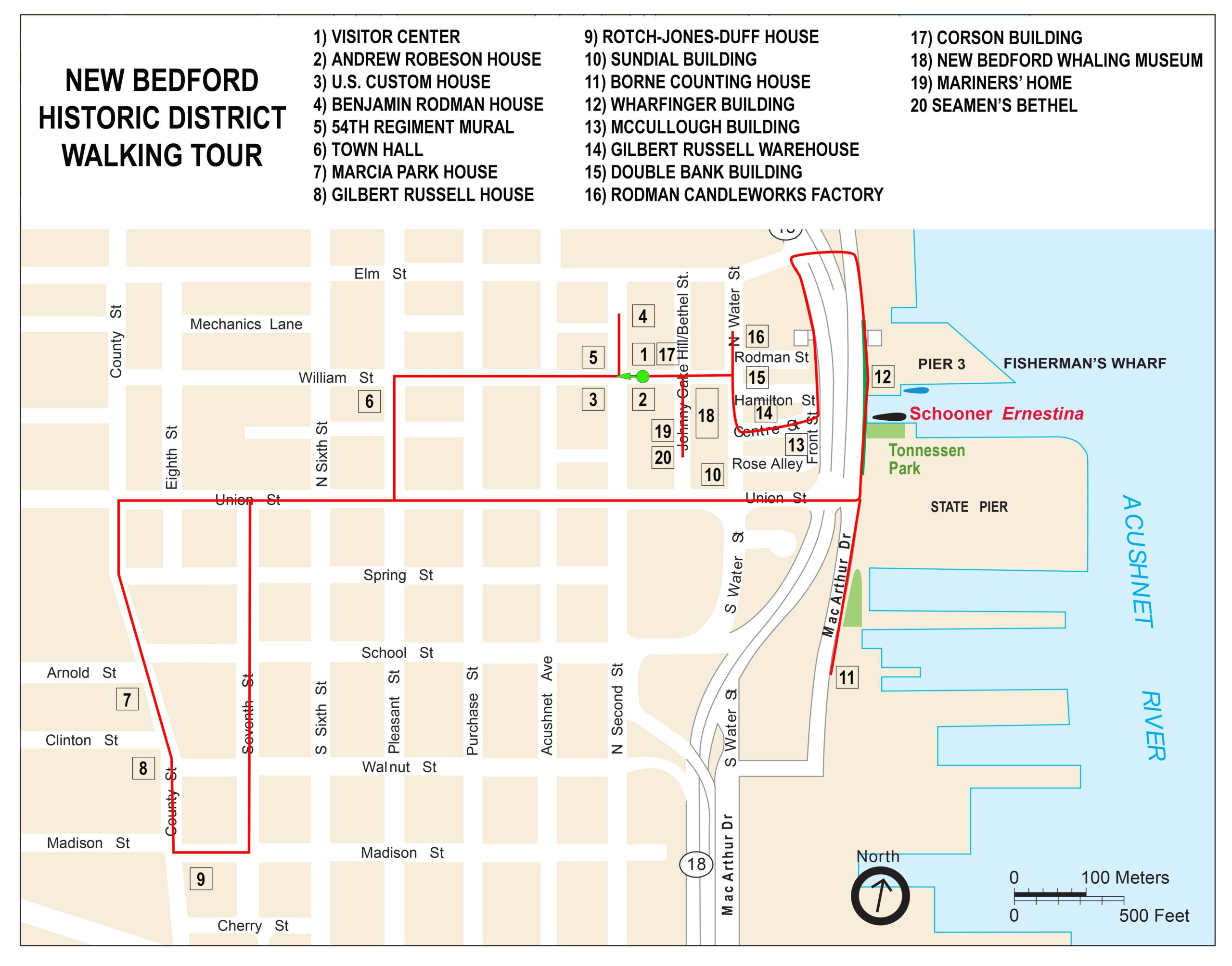
New Bedford Historical District Walking Tour Map (click to enlarge)
Stops on the tour consist of historical buildings that were preserved by the Waterfront Historic Area League (WHALE). In the 1960s and 70s, many of these buildings were in poor shape and slated for demolition or were simply in the way of progress. WHALE was able to raise funds to purchase many of these, and in some cases restore and even move them to new locations. The goal was not to turn them into museums but to either sell them to people who would maintain and use them appropriately, or rent them out as commercial spaces. Thus, most of the buildings you will see on the tour are now either retail shops, restaurants, or office spaces. A few have wayside exhibits out front that give the building’s history. I have included history for all of the buildings here on National Park Planner. If you read the written description provided below, there are links to information and photographs of each of the historical buildings that you will see on the tour.
There are three museums on the route that are open to the public: the Rotch-Jones-Duff House and Garden Museum, the Seamen’s Bethel, and the New Bedford Whaling Museum. The walking tour itself does not take much more than a couple hours, but if you stop inside the three museums, you can easily spend all day.
WALKING TOUR DETAILS
Start the tour at the Visitor Center (1 on map) for New Bedford Whaling National Historical Park, which itself is a historical building: the Old Bank Building from 1854. As soon as you step out the front door you will see two other buildings of importance. Directly across the street is the Andrew Robeson House (2), the home of a wealthy whaling merchant that was built in 1821. On the opposite corner is the U. S. Custom House (3), a Greek Revival-style government building that opened in 1834. This is where import taxes on goods arriving in New Bedford were paid.
The tour route continues west on William Street. However, before heading out, walk a short distance down North 2nd Street—away from the Custom House and Robeson House—to the building directly behind the Visitor Center. This is the Benjamin Rodman House (4). Part of Rodman’s fortune was made in the spermaceti candle business. Spermaceti is a liquid found in the skull of the sperm whale that congeals into a waxy substance used to make candles that burn brighter than any other material. When done taking a look at the house, walk back to William Street and turn right.
The building on the fourth corner of the block is of no significance, but there is a nice mural on the backside that honors the 46 black men who joined New Bedford’s Morgan Guard. This later became Company C of the 54th Regiment Massachusetts Volunteer Infantry (5), one of the first black military units put together by the Union during the Civil War.

Mural on William Street in New Bedford, Massachusetts, dedicated to the Morgan Guard
Continue down William Street until reaching Pleasant Street. Another Greek Revival building sits on the far left corner. Today it is the New Bedford Public Library, but it was the Town Hall (6) when it opened in 1839.
Take a left on Pleasant Street, a right on Union Street, and another left on County Street. The next stop on the tour is the Rotch-Jones-Duff House, but along the way are a few very impressive mansions, including the Marcia Park House (7) and the Gilbert Russell House (8). There are a number of other mansions along the side streets.

Marcia Park House on County Street in New Bedford, Massachusetts

Gilbert Russell House on County Street in New Bedford, Massachusetts
Continue down County Street until you reach Madison Street; the Rotch-Jones-Duff House and Garden Museum (9) is on the corner. If touring the house, plan to spend at least an hour. When done, continue east on Madison Street and take a left on the next street, 7th Street. This leads back to Union Street. Turn right on Union and walk all the way to the wharf.
Just before the wharf, on the corner of Union and Water streets, is a building with a sundial on the exterior wall, appropriately named the Sundial Building (10). The empty lot next to it was the site of two buildings that were blown up in a 1977 gas explosion.
When you arrive at the wharf area, use the pedestrian walkway to cross JFK Memorial Highway and MacArthur Drive. Once across, you will be at State Pier. The walking tour continues north (left), but if you want to detour south to see the only building remaining on the wharf from the 1800s, the Bourne Counting House (11) from 1847, take a right. You will also pass Steamship Pier, Coal Pocket Pier, Merrill’s Wharf, and Leonard’s Wharf. There are a few statues and monuments along the way. If you couldn’t care less about walking extra milage just to see the Borne Counting House, then turn left.

Fishing boats docked at the wharf in New Bedford, Massachusetts

Memorial to the men of the U. S. Lightship Service located on the wharf in New Bedford, Massachusetts
The schooner Ernestina-Morrissey can sometimes be found docked at State Pier, though the ship is part of the Massachusetts Maritime Academy and is usually out sailing somewhere. Built in 1894, Ernestina is one of the oldest sailing ships in the United States.
The next pier north of State Pier is Fisherman’s Wharf. It is here that you will find the Wharfinger Building (12). It used to serve as a wharf-side visitor center for New Bedford Whaling National Historical Park, but now the building is a restaurant and bar.
Continue north until reaching the pedestrian crossing area at Elm Street and make your way back over JKF and MacArthur Drive. Elm quickly comes to the intersection with highway MA-18. Cross the highway and then take a left. The sidewalk runs right along the road for a short distance before veering away and eventually coming to an old cobblestone street, Front Street. Walk along Front until reaching the intersection with Centre Street.
On the corner of Centre and Front is the McCullough Building (13) from 1820, and if you walk halfway up Centre Street—it is a fairly steep hill—you’ll find the Gilbert Russell Warehouse (14), which was built in 1822. Today it is a retail shop.

Centre Street in New Bedford, Massachusetts
Continue up Centre Street until reaching North Water Street, then turn right. The Double Bank Building (15) is a block down on the corner of North Water and Hamilton streets. Another block down is the pink Rodman Candleworks (16), the candle factory of Benjamin Rodman (it was founded by his father). Today it is a restaurant.
Take the street directly in front of the Double Bank Building, William Street, and in one block you’ll be at Johnny Cake Hill. On the opposite right-hand corner is the Corson Building (17), a commercial building dating to the late 1800s.
The last three buildings of importance are reached by taking a left on Johnny Cake Hill. Nearly the entire block on the left is occupied by the New Bedford Whaling Museum (18), and a short ways down the street is the Mariners’ Home (19) and the Seamen’s Bethel (20). The Seamen’s Bethel, made famous in Herman Melville’s Moby Dick, is open to the public. The Mariner’s House used to be open as part of the Whaling Museum, but that lease ended and now it is rented to other businesses for office space.
These are the last stops on the tour. Retrace your steps back to the Corson Building and take a left. The Visitor Center is next door.
With a few exceptions, use of any photograph on the National Park Planner website requires a paid Royalty Free Editorial Use License or Commercial Use License. See the Photo Usage page for details.
Last updated on November 24, 2025


