

Brackenridge Trail in Gulf Islands National Seashore’s Naval Live Oaks Area
Note: A portion of the Brackenridge Trail is the first part of my Naval Live Oaks Loop Hike, a 6-mile hike that covers most of the Naval Live Oaks Area of Gulf Island National Seashore. If you are interested in this hike, a link to the next trail segment is given at the bottom of this report. The Loop Hike covers .3 mile of the Brackenridge Trail’s .8 mile length.
Length: .8 mile loop
Time: 30 minutes
Difficulty: Easy

Brackenridge Trail map (rotated to the proper orientation)
The Brackenridge Trail is a double loop trail that begins at the former Naval Live Oaks Visitor Center (now National Park Service offices) at Gulf Islands National Seashore in Florida. The first loop is on a boardwalk and is suitable for those in wheelchairs. Wayside exhibits along the trail discuss the ecology of the area. It is a .3-mile walk around the boardwalk loop. The second loop is an earthen trail that is .5 mile long.

Boardwalk portion of the Brackenridge Trail at Naval Live Oaks, Gulf Islands National Seashore
The hike begins at the back of the old Visitor Center building at an observation deck with a view of Santa Rosa Sound. Take a right to get to the trail. About a hundred feet from the start, the trail splits to begin the first loop. I started the hike in the counterclockwise direction, taking a right at the fork. This report is written from that perspective.

Start of the first loop on the Brackenridge Trail in the Naval Live Oaks unit of Gulf Islands National Seashore
Halfway around the first loop, which is just .1 mile from the start, is an option to exit the boardwalk and hike the second loop, a sandy but smooth trail that adds another half mile to the hike. The only trick is knowing where to hop off the boardwalk. Your first opportunity to exit comes at a point where the boardwalk takes a sharp, 90-degree left turn. A bench marks the spot. At the corner you can see a dirt trail that appears to be the start of the second loop. However, not only is there no sign marking the intersection, but you must also hop off the boardwalk—literally—as there is no actual exit ramp. It is thus reasonable to assume that this is not the exit point and that you must continue hiking on the boardwalk.

Start of the second loop of the Brackenridge Trail in the Naval Live Oaks unit of Gulf Islands National Seashore
Not much farther ahead the trail takes another 90-degree left turn, only this time you have to option to continue straight ahead on a dirt trail and are even provided with an exit ramp. Certainly this must be the second loop. However, all this trail does is lead to a view of Santa Rosa Sound. There is a fork to the right just before reaching the Sound, but this quickly peters out into overgrown brush. As it turns out, the exit at the bench is the start of the second loop.

Second exit from the boardwalk portion of the Brackenridge Trail leads to Santa Rosa Sound, Gulf Islands National Seashore

View of Santa Rosa Sound accessed from the Brackenridge Trail in the Naval Live Oaks unit of Gulf Island National Seashore
When you hop off the boardwalk you are not actually on the second loop, but on a short connector trail that leads to the second loop just one minute down the trail. When I reached the start of the loop, I once again chose to stay to the right, continuing in the counterclockwise direction.
The second loop is slightly hilly, but it is never anything more than an easy hike. It differs from the first loop only in that it is not a boardwalk (no wheelchair access), and there are no wayside exhibits along the way. The trail circles through a forest of Live Oaks and palmetto bushes. There is shade the entire time, but keep in mind that if you plan to connect to the trails on the other side of Gulf Breeze Parkway, these are all out in the open, so bring sunscreen and a hat with you if avoiding the sun is important.

Typical terrain on the second loop of the Brackenridge Trail, Gulf Islands National Seashore
The Brackenridge Trail intersects with the Fishing Trail at the far end of the loop, .3 mile from the start. For those hiking the Brackenridge Trail and not my Naval Live Oaks Loop Hike, when you come to the intersection, stay left to remain on the Brackenridge Trail. This will bring you back to the connector trail at the start of the second loop, at which point you take a right to return to the boardwalk. Total distance around both loops is about .8-mile.
NAVAL LIVE OAKS LOOP HIKE
To continue on the Naval Live Oaks Loop Hike, when the Brackenridge Trail intersects with the Fishing Trail, take the fork to the right to get on the Fishing Trail, the next leg of the journey. A sign marks the intersection. See the Fishing Trail web page for further information.

Start of the Fishing Trail at Gulf Islands National Seashore’s Naval Live Oaks
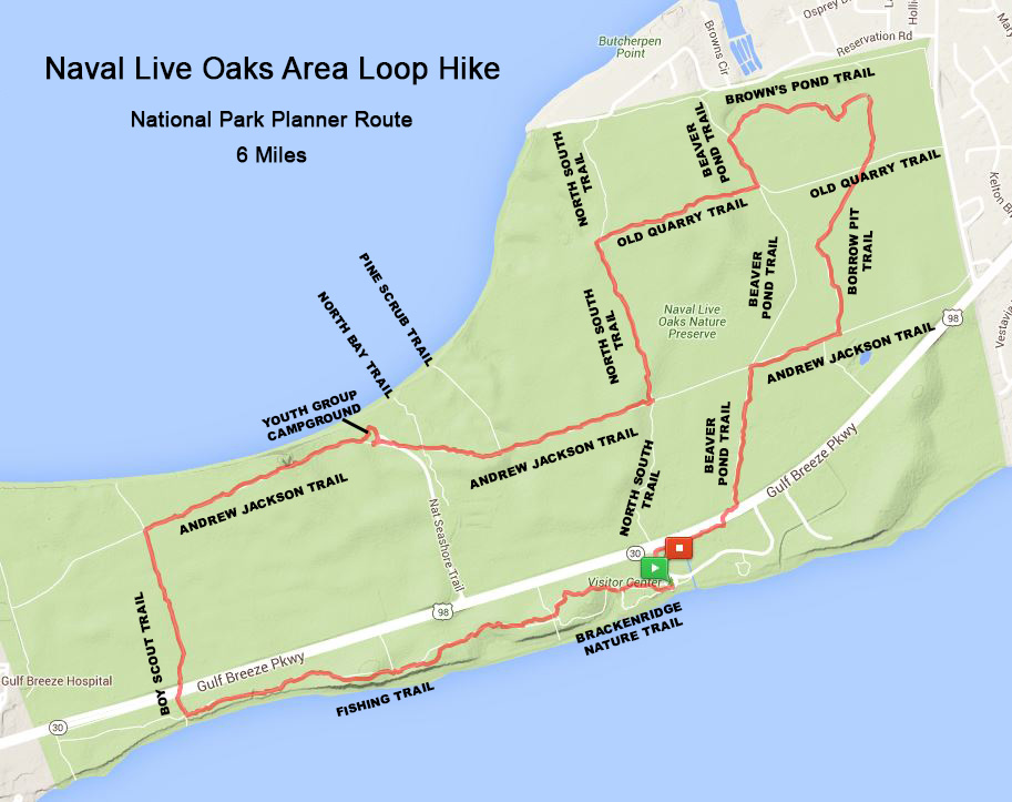
Naval Live Oaks Loop Hike map (click to enlarge)

Brackenridge Nature Trail portion of the Naval Live Oaks Loop Hike
With a few exceptions, use of any photograph on the National Park Planner website requires a paid Royalty Free Editorial Use License or Commercial Use License. See the Photo Usage page for details.
Last updated on March 7, 2025


