

Fishing Trail at Gulf Islands National Seashore’s Naval Live Oaks Area
Note: A portion of the Fishing Trail is part of my Naval Live Oaks Loop Hike, a 6-mile hike that covers most of the Naval Live Oaks Area of Gulf Island National Seashore. If you are interested in this hike, a link to the next trail segment is given at the bottom of this report. The Loop Hike covers 1 mile of the Fishing Trail’s 1.2 mile length.
Length: 1.2 mile, one way
Time: 30 minutes
Difficulty: Easy

Fishing Trail portion of the Naval Live Oaks Loop Hike
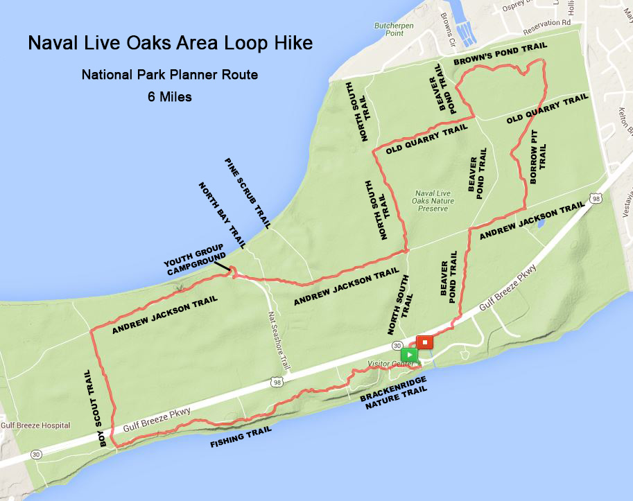
Naval Live Oaks Loop Hike map (click to enlarge)
The Fishing Trail runs east to west along the Santa Rosa Sound from the halfway point on the second loop of the Brackenridge Trail all the way to the western boundary of the Naval Live Oaks unit of Gulf Islands National Seashore, a 1.2-mile one-way trek. You must hike .3 mile on the Brackenridge Trail to get to it. There is absolutely no point in hiking this trail on its own unless you are simply looking for exercise. There is nothing much worth seeing along the way other than a few stands of Live Oaks, and it gets no better the second time around as you make your way back. Thus, the only reason to hike the trail would be as part of a larger loop hike around the Naval Live Oaks Area, which is my intention with the Naval Live Oaks Loop Hike.

Live Oaks along the Fishing Trail in the Naval Live Oaks unit of Gulf Islands National Seashore
The intersection with the Brackenridge Trail is marked with a sign. When you reach this spot, take a right onto the Fishing Trail. If you are following my Naval Live Oaks Loop Hike, the only thing you need to do at this point is to keep hiking until the trail intersects with the Boy Scout Trail one mile away. This is the next leg of the journey.

Eastern trailhead for the Fishing Trail in the Naval Live Oaks unit of Gulf Islands National Seashore
The Fishing Trail parallels Gulf Breeze Parkway, and you are close enough to it to hear the traffic noise. There are a few right-hand turns that lead up to the Parkway, the first coming not long after the intersection with the Brackenridge Trail. There are other narrow side trails here and there, but these are “social trails” that are not on the map. Social trails are those blazed by hikers over the years as they try to get to a certain spot or to create a shortcut.
Most of the trails that lead to Santa Rosa Sound are overgrown and don’t give much of a view. Furthermore, the eastern end of the Fishing Trail is high up on a ridge, so you’d have to scurry down a steep hill to get to the beach. I took one of these trails, and not long afterwards I noticed a tick crawling up my pants. Simply walking off the main trail for just a moment and rubbing up against nothing more than a patch of short grass landed me a tick. I always hike in long pants for this reason (that and to avoid poison ivy and getting scraped up by briers), but no matter what you are wearing, whenever you brush up against vegetation, check your legs, front and back, for ticks. You will almost always find them crawling up the front of your leg since that’s the direction you run into them. If you have on shorts, they can crawl up to your crotch in just a few minutes, so check frequently.

View of Santa Rosa Sound from a ridge on the Fishing Trail in the Naval Live Oaks unit of Gulf Islands National Seashore
The Fishing Trail is flat and easy to hike and has a hard-packed, sandy surface, not deep beach-type sand. Most of it is wide, though there are a few narrow stretches that get a little overgrown. The entire trail runs though the forest, so there is plenty of shade —no need yet for sunscreen. However, if you plan to connect to the trails on the other side of Gulf Breeze Parkway, keep in mind that these are all out in the open.

Typical terrain of the Fishing Trail in the Naval Live Oaks unit of Gulf Islands National Seashore
The Fishing Trail appears to dead end into another trail one mile from the start. This is the Boy Scout Trail, the end of the line for the Fishing Trail if you are following my Naval Live Oaks Loop Hike. The Fishing Trail actually continues another .2 mile, though you must jog slightly to the left on the Boy Scout Trail before taking a right to get back onto the Fishing Trail and continuing to the western park boundary, which butts up to a large shopping center. To continue the Naval Live Oaks Loop Hike, you’ll want to take a right and head out to Gulf Breeze Parkway where the Boy Scout Trail continues on the other side of the road. But for a pretty view, first take a left and make the short detour to the Santa Rosa Sound.

Intersection of the Fishing Trail and Boy Scout Trail in the Naval Live Oaks unit of Gulf Islands National Seashore

Santa Rosa Sound at the Fishing Trail / Boy Scout Trail intersection in the Naval Live Oaks unit of Gulf Islands National Seashore

Beach along Santa Rosa Sound accessed via the Fishing Trail at Gulf Islands National Seashore
To continue on the Naval Live Oaks Loop Hike, take a right on the Boy Scout Trail. See the Boy Scout Trail web page for further information.
With a few exceptions, use of any photograph on the National Park Planner website requires a paid Royalty Free Editorial Use License or Commercial Use License. See the Photo Usage page for details.
Last updated on March 7, 2025


