

Delaware River between Lackawaxen and the Highland, NY DEC Canoe Launch, Upper Delaware Scenic and Recreational River
Length: 3 miles
Water Level at Time of Trip: 3.1 feet to 3.9 feet
Average moving speed: 3.4 MPH with two paddlers
Time: 50 minutes
This river review covers the Delaware River from the Lackawaxen Boat Ramp at the Zane Grey Museum in Pennsylvania to the Highland Canoe Launch in Barryville, New York, a span of 3 miles. The ramp at the Zane Grey Museum is concrete and suitable for launching motorboats and hand-paddled watercraft. It is a convenient location to start a trip down the Upper Delaware Scenic and Recreational River.
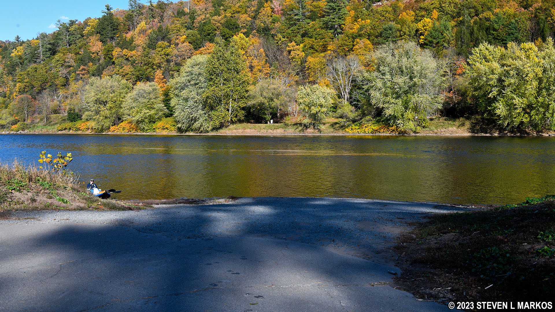
Lackawaxen Boat Ramp at the Zane Grey Museum, Upper Delaware Scenic and Recreational River
Before starting a trip on the Upper Delaware Scenic and Recreational River, it is a good idea to check the water levels so that you have an idea of the river conditions. Levels of 2.5 to 4 feet are average and provide plenty of water for a trip down the river with conditions suitable for paddlers of all skill levels. The water level gauges relevant to the Lackawaxen–Highland section of the river are positioned just north of Lackawaxen, Pennsylvania (1.75 mile upriver from the Zane Grey Museum) and at Barryville, New York (2 miles downriver from Highland). On the day of my trip in late October, the Lackawaxen gauge read 3.15 feet and the Barryville gauge 3.93 feet. The observations made in this report are based on these water levels, so adjust your expectations according to the conditions on the day you do the trip. The lower the water, the more often you will hit rocks on the bottom of the riverbed and get stuck. The higher the water, the more paddling skills you need.
Upon departing from the Zane Grey Museum, you will be heading towards the Roebling Delaware Aqueduct that was once part of the Delaware and Hudson canal. Originally designed to carry water and canal boats over the Delaware River, it was converted into a vehicle bridge when the canal shut down in 1898, and it is still operated that way. The National Park Service now owns it. Visitors can walk across the bridge and step inside the restored toll house that was built in 1900 to collect vehicle tolls (no tolls are collected today).

Roebling Aqueduct at Lackawaxen, Upper Delaware Scenic and Recreational River
The bridge is just a quarter mile downriver from the boat ramp. What you need to be aware of is that there is a man-made ledge of rock just before the bridge. When built, the canal dead-ended at the Delaware River on both sides. Prior to the construction of the aqueduct, canal boats had to float across the open river, battling the current, to get from one section of the canal to the other. To slow the current and make things easier for the boat operators, a 16-foot-tall dam was built to create a slackwater pool. The rock ledge is the remnants of the dam, and you must go around it or risk getting stuck. I didn’t know this at the time and aimed for the middle of the bridge where the ledge is located and got stuck (if the water were higher, I might have floated right over it). To avoid this happening to you, once you depart from the museum, either head to the other side of the river and pass under the left side of the bridge or hug the Pennsylvania shoreline and pass under the right-hand bridge support column. Where you see what appears to be riffles, that’s the rock ledge.

Remnants of the Delaware and Hudson Canal slackwater dam just upstream from the Roebling Aqueduct, Upper Delaware Scenic and Recreational River

View of the remnants of the Delaware and Hudson Canal slackwater dam from the Roebling Aqueduct, Upper Delaware Scenic and Recreational River

Underside of the Roebling Aqueduct in Lackawaxen, Pennsylvania, Upper Delaware Scenic and Recreational River
There are some small rapids just after passing under the Roebling Aqueduct, and then the water calms down until the very end of the trip to Highland.

Rapids downstream from the Roebling Aqueduct in Lackawaxen, Pennsylvania, Upper Delaware Scenic and Recreational River

Calm section of the Delaware River downstream from the Roebling Aqueduct in Lackawaxen, Upper Delaware Scenic and Recreational River
You’ll know you are near the Highland Canoe Launch when you come to a group of river outfitters: Lander’s River Trips, Indian Head Canoes, and Kittatinny Canoes and Campground, which is where I was camping. These outfitters like to set up shop adjacent to calm water (for launching) but just upstream from some decent rapids. This way, as soon as their customers depart the boat ramp they are thrust right into the action. Just after passing Indian Head, and again just after Kittatinny Canoes, the current starts picking up, and before you know it, you are riding some fast moving water. The rapids are small but fun. Just be sure to dodge the exposed rocks.

Rapids upstream from the Highland, NY DEC Canoe Launch on the Upper Delaware Scenic and Recreational River
Just before the Highland Canoe Launch is a private ramp at the Cedar Rapid Bar and Grill, which is affiliated with Kintatinny Canoes, and a short run of rapids. As soon as you get to the end of the rapids, head to the New York (right) side of the river. The Highland launch is a quarter mile from the end of the rapids.
When I did my river trip, the Highland launch was getting a makeover and was nothing but a construction site, so unfortunately I don’t have a photo other than of the construction. With the old launch, you had to tote your boat and gear down a fairly steep gravel path. The new path is paved and not as steep. I’m pretty sure you cannot drive down to the water, but carrying your equipment should now be a little easier. By the time you read this, the construction will have been completed.
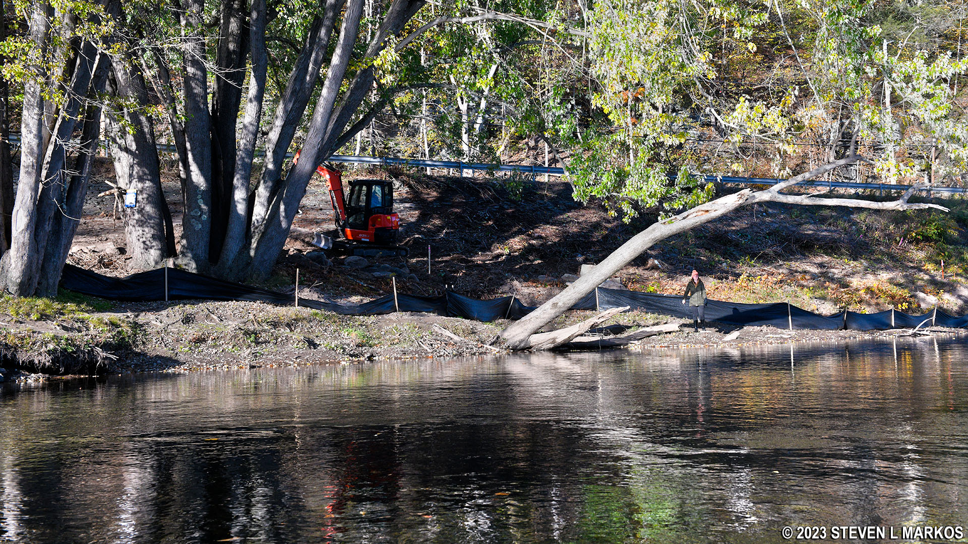
Highland NY DEC Canoe Launch under construction, Upper Delaware Scenic and Recreational River
Next River Section | Previous River Section | River By Section Home Page
With a few exceptions, use of any photograph on the National Park Planner website requires a paid Royalty Free Editorial Use License or Commercial Use License. See the Photo Usage page for details.
Last updated on August 19, 2023


