
Inner Blue Mountain Lake Trail in Delaware Water Gap National Recreation Area
Blue Mountain Lake Area Trails Home Page
Length: 2.25-mile loop
Time: 1.5 hours
Difficulty: Easy to moderate with one very steep-but-short hill
The Blue Mountain Lake Trail in Delaware Water Gap National Recreation Area is located in New Jersey between Millbrook Village and Walpack Center. If using Google Maps for directions, search “Blue Mountain Lakes Walpack.” The trail has its own parking lot on Blue Mountain Lakes Road. There is also a restroom and a few picnic tables.
National Park Service literature refers to the trails in this area in the singular: the Blue Mountain Lake Trail. However, there are really two trails, an inner loop that goes around the shore of Blue Mountain Lake and an outer loop that goes nowhere near the lake and extends all the way to Hemlock Pond. There are connectors between the two, but the layout essentially makes these two separate hiking trails. The National Park Service gives the distance of the “Blue Mountain Lake Trail” as 4.6 miles, which is the distance of what I will call the Outer Blue Mountain Lake Trail (or Outer Trail). This is the trail to hike if you just want exercise because there is nothing to see. If you are looking for a scenic hike around a lake, then you want what I will call the Inner Blue Mountain Lake Trail (or Inner Trail). This review covers the Inner Trail.
There are many trails in this area that are not on the map provided by the National Park Service, neither on the official Delaware Water Gap National Recreation Area website nor on the printed map provided in the Guide to the Gap, a tabloid-size brochure that is available for free at any visitor center. I have made corrections that I know of to the government-issued map (below). Corrections are shown as red dotted lines.

Corrected trail map for the Blue Mountain Lake area of Delaware Water Gap National Recreation Area (click to enlarge)
Due to the numerous intersections in this area that are not on the trail map and that have no directional signage, it is important to know that the route of the Outer Blue Mountain Lake Trail is marked with blue blazes and the Inner Blue Mountain Lake Trail with red blazes. These are paint splotches on trees that serve as Hansel and Gretel breadcrumbs.
Regardless of which trail you plan to hike, the trailheads are at the far end of the parking lot next to two signs. The gated dirt road is the start of the Outer Blue Mountain Lake Trail heading in the clockwise direction. The narrower path to the right leads to the start of the Inner Blue Mountain Lake Trail loop and the Outer Blue Mountain Lake Trail in the counterclockwise direction. I took narrow trail.

Trailheads for the Blue Mountain Lake Trails at Delaware Water Gap National Recreation Area
While the trail starts off as a narrow path, it widens into an obvious former dirt road just around the corner. A hundred yards later is the start of the Inner Blue Mountain Lake Trail loop, an intersection that is on the National Park Service map but has no directional signage. The road continues straight ahead while a narrower trail forks off to the left. There is a double red blaze that stairsteps to the left on a tree at the intersection. A double blaze indicates a turn, and the direction of the stairstep indicates which way to turn. Per the blazes, the Inner Trail is to the left.

Start of the Inner Blue Mountain Lake loop is a hundred yards from the parking lot, Delaware Water Gap National Recreation Area
What the blazes do not tell you is that the road is the Inner Trail in the counterclockwise direction. They also don’t tell you that staying straight on the road leads to the Outer Blue Mountain Lake Trail, also in the counterclockwise direction. I followed the double blaze to the left, hiking around the Inner Trail in the clockwise direction, and this trail report is written from that perspective.

Typical terrain at the start of the Inner Blue Mountain Lake Trail in the clockwise direction, Delaware Water Gap National Recreation Area
No sooner did I turn left than there is another fork, this time one that is not on the National Park Service map (see the corrected map above). The right fork is actually the official Inner Blue Mountain Lake Trail, and it leads to the dam and a view of the lake. The left fork connects to the Inner Trail a little west of the dam—there are no views of the lake this way. I went to the right, and I don’t see any reason why you shouldn’t as well.

Fork on the Inner Blue Mountain Lake Trail that leads to the dam, Delaware Water Gap National Recreation Area
The Inner Blue Mountain Lake Trail comes up on the backside of the dam, so you have to climb up a steep concrete embankment to get to the lake. The dam is .3 mile from the parking lot.

Backside of the dam at Blue Mountain Lake in Delaware Water Gap National Recreation Area

View of Blue Mountain Lake from the dam, Delaware Water Gap National Recreation Area

Dam at Blue Mountain Lake in Delaware Water Gap National Recreation Area
To continue the hike, head left from the dam across a slab of rock and into the forest (you’ll see a red blaze on the tree). The trail heads up a steep hill for a hundred yards until coming to the intersection with the unmapped trail that forked off to the left. As you can see, if you had taken that trail, you would have missed the lake completely.

The Inner Blue Mountain Lake Trail continues to the left of the dam, Delaware Water Gap National Recreation Area
At this point the trail curves to the right and begins following what I will call the northern shore of Blue Mountain Lake. The trail, which is still an old road, covers hilly terrain, but most of the hills are mild with average grades between 8% and 10% (15% is where strenuous starts). The surface is relatively free of rocks and roots, and overall it is an easy trail to hike. I’d rate the difficulty a 2 on a scale of 1 to 5 (with five being the most strenuous).

Typical terrain along the Inner Blue Mountain Lake Trail as it follows the lake’s northern shore, Delaware Water Gap National Recreation Area

Typical terrain along the Inner Blue Mountain Lake Trail as it follows the lake’s northern shore, Delaware Water Gap National Recreation Area
While the trail follows the shoreline of Blue Mountain Lake, it is never close to the water. You can see the lake through the trees, and there are a few paths people have cut through the brush down to the shore. But don’t worry. A quarter-mile section of the trail on the other side of the lake runs so close to the shore that you can jump right in.

Social trail cut by hikers from the Inner Blue Mountain Lake Trail to the lake, Delaware Water Gap National Recreation Area
At .7 mile on the hike is an intersection with what appears to be some sort of trail that branches off to the left. It is outlined with the remnants of a stone fence on either side. This is actually not a trail at all but some sort of C-shaped driveway that reconnects to the main trail a little farther ahead (one end heads up a very steep hill). This may once have been the driveway of a farmhouse or perhaps just a way to turn around when the Inner Blue Mountain Lake Trail was still being used as a road.

C-shaped driveway branches off from the Blue Mountain Lake Trail in Delaware Water Gap National Recreation Area
The far end of the loop comes about one mile into the hike. At this point the trail forks, with a left being a connector over to the Outer Blue Mountain Lake Trail. Stay right to continue on the Inner Trail as it curves around and starts heading back to the parking lot. Along this curve is what is easily the steepest hill on this and the Outer Trail. It is only about 400 feet long, but the average grade for the first two thirds of the distance is 23%, and there are a lot of loose rocks to slip on. The photo below is of the descending trail. It doesn’t look very steep because it is hard to show the steepness of downhill trails in a two dimensional photo.

Steep hill at the far end of the Inner Blue Mountain Lake Trail in Delaware Water Gap National Recreation Area
By the time you get to the bottom of the hill you will have circled around and are now heading southwest back towards the parking lot. The overall trajectory of the trail on this side of the lake is downhill, but again, all hills are mild, and in most cases you won’t even realize you are hiking downhill.

Typical terrain along the Inner Blue Mountain Lake Trail at the eastern end of the lake’s southern shore, Delaware Water Gap National Recreation Area
I mentioned earlier that the Inner Trail comes close enough to the lake that you could jump right in, but as you continue southeast you’ll see the lake, but you won’t be any closer than you were on the other side. However, at the 1.7-mile mark on the hike is a grass path on the right that leads down to the lake. You have the option to keep hiking straight ahead and coming no closer to the lake, but why would anyone want to do that? Take the grass path and you’ll be at the water in no time.

Grass path to the shore of Blue Mountain Lake in Delaware Water Gap National Recreation Area

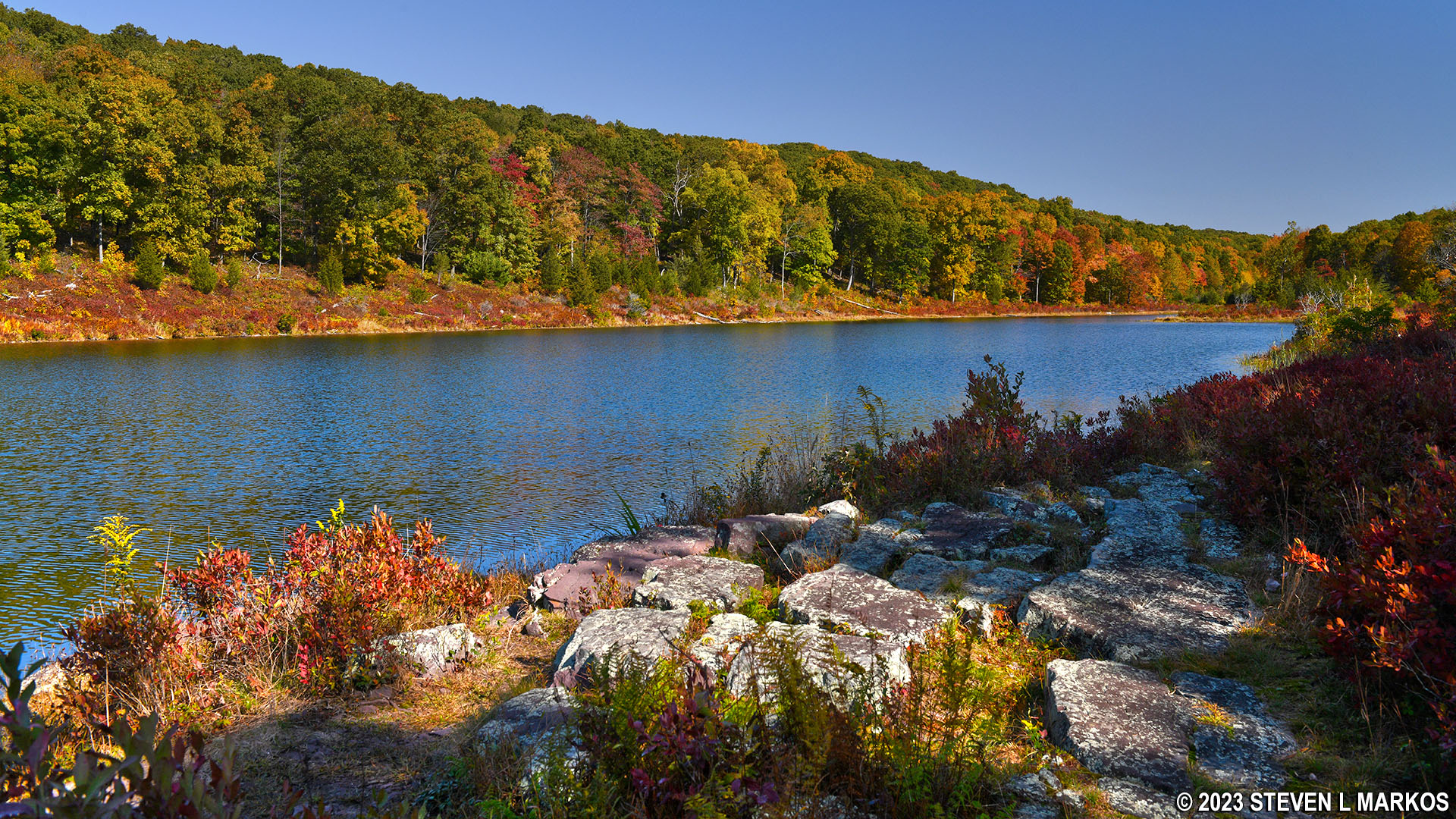
The Inner Blue Mountain Lake Trail eventually follows right along the southern shore of Blue Mountain Lake, Delaware Water Gap National Recreation Area
At this point you can hike right along the shore all the way back to the dam, a quarter mile of great views. The terrain is a little rough because the trail is no longer an old dirt road, but this is the official trail. There are red blazes on the trees.

Inner Blue Mountain Lake Trail on the southern side of the lake, Delaware Water Gap National Recreation Area
When you get to the dam, don’t walk back over it because you’ll just end up where you started. Be on the lookout for a trail that forks off to the left into the forest just before you set foot on the dam.

View from the eastern side of Blue Mountain Lake Dam, Delaware Water Gap National Recreation Area

Trail back to the parking lot from the eastern side of the Blue Mountain Lake Dam, Delaware Water Gap National Recreation Area
The trail back to the Blue Mountain Lake Parking Lot is the dirt road you started out on. You’ll pass the intersection where the Outer Blue Mountain Lake Trail begins (to the left) before coming to the very first fork where the loop started. Just keep going straight all the way back to the parking lot.

Inner Blue Mountain Lake Trail near the parking lot at Delaware Water Gap National Recreation Area
With a few exceptions, use of any photograph on the National Park Planner website requires a paid Royalty Free Editorial Use License or Commercial Use License. See the Photo Usage page for details.
Last updated on January 31, 2026


