
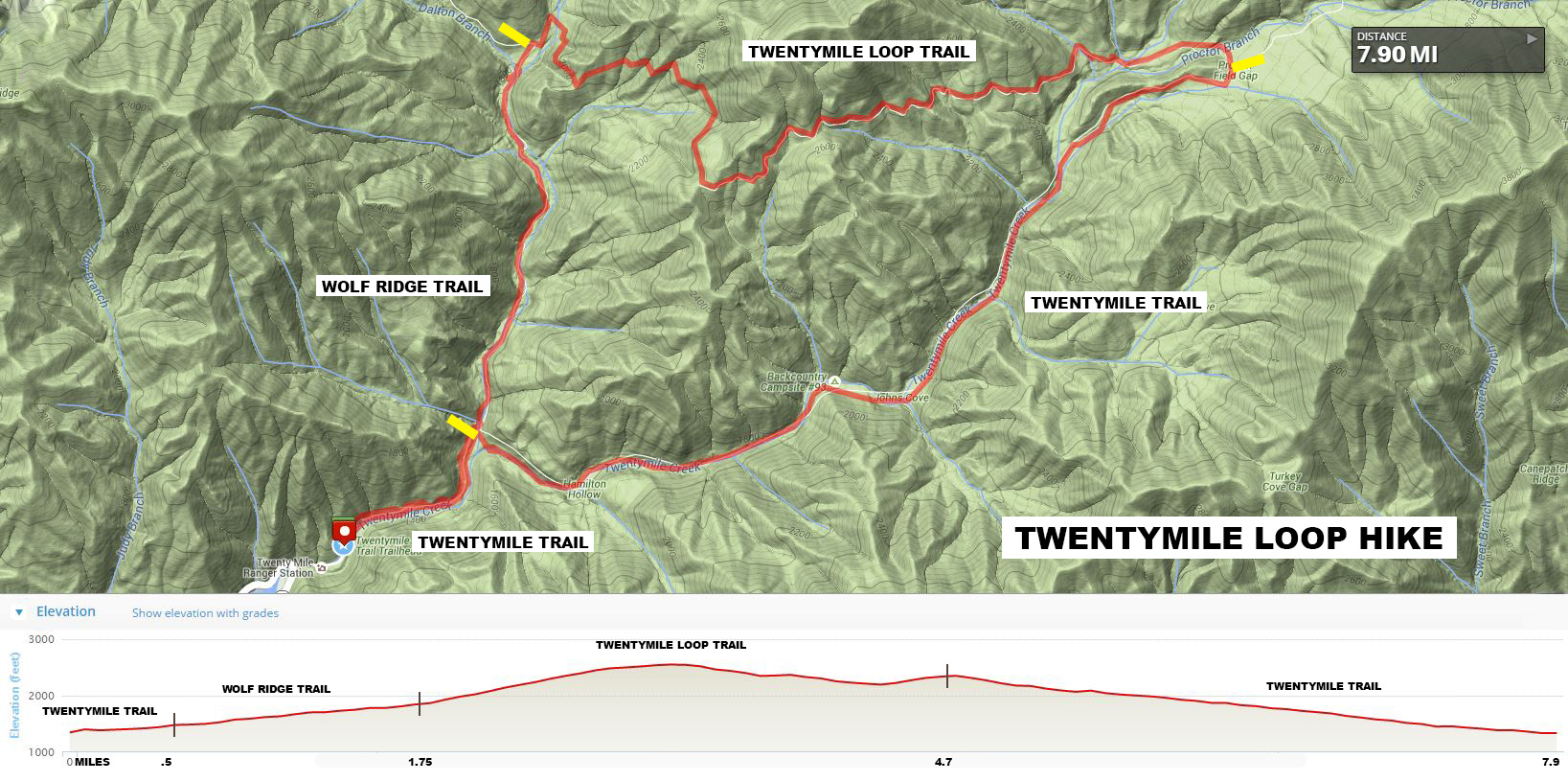
Twentymile Loop Hike map (click to enlarge)
See the Twentymile Region web page for a location map.
Length: 7.9 mile loop
Difficulty: Mostly easy with some moderate stretches
Time: 4.5 hours
The Twentymile Loop Hike is comprised of three trails in the Twentymile Region of Great Smoky Mountains National Park: a portion of the Wolf Ridge Trail and Twentymile Trail, plus the entire Twentymile Loop Trail (despite its name, this trail does not form a loop on its own, it only connects the other two trails together). You can start the loop hike on either the Wolf Ridge Trail (clockwise direction) or the Twentymile Trail (counterclockwise direction). For the record, I hiked in the clockwise direction.
To reach the trailhead, turn off of Hwy 28 when you see the Twentymile park entrance. A short, dirt road leads to the trail parking lot. If it is full, just pull over on the shoulder of the road. On the way you will pass the Twentymile Ranger Station and a fire station. Neither were open when I visited, and I first thought they were abandoned buildings from the 1930s, a time when the government was buying up property in the area to create the Great Smoky Mountains National Park. I had to park by the buildings due to the lot being full, but don’t worry about the crowd—it’s a big area and a small parking lot.

Twentymile Ranger Station in Great Smoky Mountains National Park
Technically, the trail at the end of the road is Twentymile Trail, though it really is just a continuation of the dirt road. A gate bars unauthorized vehicles from venturing farther. From here you have a half-mile walk to the intersection with the Wolf Ridge Trail and the beginning of the loop portion of the hike.

Start of Twentymile Trail in Great Smoky Mountains National Park
WOLF RIDGE TRAIL
As mentioned, I started out on the Wolf Ridge Trail and hiked the loop in a clockwise direction. A sign at the intersection with Twentymile Trail points the way. From the parking lot to the intersection, the trail angles its way uphill and continues in this manner until the Wolf Ridge Trail. However, the incline is not very steep and won’t be a problem for anyone who set out on an 8-mile hike in the first place. The Wolf Ridge Trail remains “road-like,” and though noticeably narrower, I am certain this was also a road at some point in time. The terrain is smooth and largely free of rocks except when you get close to Moore Springs Branch, a small creek the trail crosses three times. Vehicles could have easily crossed as well, and I can picture the Ol’ Timers in their Ford and Chevy pick-ups driving on this trail to get to their homes or to go hunting.

Typical terrain of the Wolf Ridge Trail in the Twentymile region of Great Smoky Mountains National Park
Moore Springs Branch flows downhill and eventually empties into Cheoah Lake, a dammed-up Little Tennessee River. Wolf Ridge Trail crosses the creek a number of times by way of what I call Indiana Jones bridges. These are single logs with a wood railing attached to them. If you were in an Indiana Jones movie and bad guys were chasing you as you tried to cross a chasm, they’d be rocking the log back and forth in an attempt to make you fall. There are no bad guys here (hopefully), but when crossing the bridge, if you look down at the rushing water flowing under your feet, it is easy to get a little dizzy.

The Wolf Ridge Trail crosses Moore Springs Branch via an Indiana Jones bridge, Great Smoky Mountains National Park
The first creek crossing comes at the 1-mile point on the hike. Just before the bridge is an unmarked trail that branches off to the right. Horseback riding is allowed on the Wolf Ridge Trail, and this side trail just leads down to the creek where horses can cross since they obviously cannot cross on the bridge—unless you have a very talented horse. Just stay straight on the main trail. You will see other such unmarked trails whenever you come to a bridge over the creek.
Just a couple of minutes after the first creek crossing is a second crossing, again on an Indiana Jones bridge. The trail is really rocky between the two crossings and continues uphill, but once you cross the second bridge it levels out and the terrain is not as rough. The farther you get from the creek, the smoother the terrain.

Second crossing of Moore Springs Branch on the Wolf Ridge Trail in Great Smoky Mountains National Park
There is one last creek crossing before coming to the Twentymile Loop Trail. This time, however, the trail becomes the horse crossing and it is the hikers who must veer off to the bridge. If you aren’t paying attention, you will find yourself starring at a rapidly flowing creek with no way across other than wading. The bridge is slightly obscured by rhododendrons, but it is off to the right.
After this crossing, Twentymile Loop Trail is less than five minutes away. Total distance on the Wolf Ridge Trail is 1.25 miles. Total distance from the start of the hike is 1.75 miles. Difficulty ranges from easy to slightly more than easy, but rarely moderate. Although you were walking uphill the entire way, most of the time you won’t even notice it.
TWENTYMILE LOOP TRAIL
The Twentymile Loop Trail connects the Wolf Ridge and Twentymile Trails together. When hiking the loop in the clockwise direction, the Wolf Ridge Trail is uphill and Twentymile Trail is downhill, so it might stand to reason that once you get to Twentymile Loop Trail that you have reached the top of a ridge and are now about to embark on a fairly level trip between the two other trails. This isn’t quite the case, but the general idea is sound. In reality, you continue uphill for another mile on a much steeper incline than you encountered when coming up Wolf Ridge, but then the trail levels off somewhat and you proceed an additional two miles to Twentymile Trail on what amounts to be a hilly trail with plenty of small ups and downs.
At the intersection, the Wolf Ridge Trail forks off to the left, so you actually continue hiking straight ahead to get onto Twentymile Loop Trail. The intersection is well marked with directional signage. You are no longer on a former road, but on a narrow hiking trail. The trail surface does, however, remain relatively smooth, especially for a trail in Great Smoky Mountains National Park.
Twentymile Loop Trail continues to follow a creek—I do not know the name—and there is a crossing with a scenic cascade just a couple of minutes from the start. To get a good view you must walk down to the creek.

Cascading water flows under a bridge on Twentymile Loop Trail in Great Smoky Mountains National Park
Just after crossing the creek, the trail starts to climb at a moderate pace, but it often utilizes switchbacks to keep from getting too steep. The trail leaves the water behind and eventually you are just hiking uphill through the forest with not much to see. Oftentimes you will find yourself on a ridge with a mountain on one side and a steep drop-off on the other. You won’t fall to your death, but you may well end up seriously injured if you were to tumble down the hill. The trail is very narrow in these instances, often no wider than your body, and the edge nearest to the drop is quite soft. If you plant your foot wrong, you may find yourself on the way to the bottom, so stay as far away from the edge as possible. The good news is that the terrain remains smooth, so there is no need to worry about tripping over a root or twisting an ankle on a half-buried rock.

Narrow section of the Twentymile Loop Trail along a ridge, Great Smoky Mountains National Park
The trail levels out a little over a mile from the Wolf Ridge intersection and remains flat for the next half mile. After that it is populated with a few small hills until you reach the Twentymile Trail. At the 4-mile point on the overall hike you must cross a small stream on stepping stones and, shortly after that, Twentymile Creek on an Indiana Jones bridge. From here you have one last, short climb before coming to the Twentymile Trail, which is now less than a half mile away. For those looking to take a break, there is a nice “sitting” rock along the trail, the only decent place I found to sit other than on the ground.

A large rock provides a nice place to rest along Twentymile Loop Trail in Great Smoky Mountains National Park
The Twentymile Loop Trail is a pleasurable hike, though not particularly interesting. The Wolf Ridge Trail benefited from running along a scenic stream, but there’s none of that here. The majority of the hike along Twentymile Loop is easy, with maybe a third being of moderate difficulty. Total distance on this trail is roughly 3 miles. Total distance to Twentymile Trail is 4.7 miles.
TWENTYMILE TRAIL
The intersection with the Twentymile Trail is actually a three way intersection, as you can also pick up the Long Hungry Ridge Trail from here as well. You want to follow the sign for the Twentymile Trail in the direction of the Twentymile Ranger Station, which is approximately three miles away. Cross to the far side of the intersection to get on the Twentymile Trail.
Like the Wolf Ridge Trail, Twentymile Trail is a former road, so it’s smooth sailing all the way back to the parking lot. It is also downhill the entire time, though the decline is mild and often insignificant. This is without a doubt the easiest segment of the hike.

Typical terrain of the Twentymile Trail in Great Smoky Mountains National Park
Twentymile Trail is also the most scenic of the three segments. While the trail initially veers from Twentymile Creek, it eventually meets back up with it, and you walk right beside the water just like having your best girl at your arm. I was able to get one of my favorite photos from a standard road bridge that crossed the creek.

Cascading waters of Twentymile Creek as seen from the Twentymile Trail in Great Smoky Mountains National Park

Twentymile Creek in Great Smoky Mountains National Park
A second photo op comes at the 7.25-mile mark, which is near the end of the hike. Look for a side trail that leads down a very steep hill via three switchbacks to Twentymile Creek Cascades, a long series of picturesque cascades that run a good ways down the creek. The trail come out in the middle of cascades, and while this is not the best spot to get a photo, it is the most convenient. You can get better photos farther down the creek, but you’d have to Lewis-and-Clark-It™ through the brush to get there.

Twentymile Creek Cascades in Great Smoky Mountains National Park
When leaving, do not go back the same way you came down. The side trail to the cascades forms a C-shaped in-and-out, so continue on the trail and you will come out farther down Twentymile Trail, having missed nothing of interest. You are also now within sight distance of the original intersection with the Wolf Ridge Trail, the end of the loop. Take a left and you’ll be back at the parking lot in less than fifteen minutes. Total distance on the Twentymile Trail, including the stretch back to the parking lot, is 3.2 miles, all easy, slightly downhill hiking.
CONCLUSION
There are very few trails in Great Smoky Mountains National Park that form loops on their own, so you must create a loop hike out of multiple trails, as is the case with the Twentymile Loop Hike. Based on the other loop hikes I did, there’s always one fun trail, while the others pretty much suck. Not the case here. Both the Wolf Ridge and Twentymile Trail were fun, scenic hikes along creeks, and while the Twentymile Loop Trail offered nothing of interest, it was fairly easy and didn’t require much effort to hike. Despite the full parking lot, I never saw another person on the trail. The Twentymile Region upheld is reputation as an out-of-the-way place to go to get away from the crowds.
With a few exceptions, use of any photograph on the National Park Planner website requires a paid Royalty Free Editorial Use License or Commercial Use License. See the Photo Usage page for details.
Last updated on February 27, 2025


