

Final leg of the Naval Live Oaks Loop Hike (click to enlarge)
Length: .75 mile
Difficulty: Easy
The final stretch of the Naval Live Oaks Loop Hike uses segments of two trails that were hiked earlier: the Andrew Jackson Trail and the Beaver Pond Trail. The hike also includes a return back to the Naval Live Oaks parking lot along the paved Multi-Use Path that follows alongside Gulf Breeze Parkway.
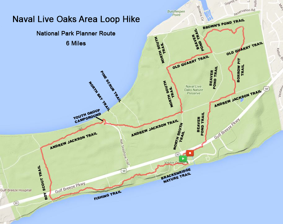
Naval Live Oaks Loop Hike (click to enlarge)
ANDREW JACKSON TRAIL
The final leg of the Naval Live Oaks Loop Hike once again uses a segment of the Andrew Jackson Trail, a former road built in 1824. What is left of it today is about as wide as a horse carriage road. I arrived at the trail from the north on the Old Borrow Pit Trail. At the intersection, which is unmarked, take a right. The Old Borrow Pit Trail actually dead ends into the Andrew Jackson Trail, so you can’t miss the turn.

Intersection of the Old Borrow Pit and Andrew Jackson Trail in the Naval Live Oaks unit of Gulf Islands National Seashore
I hiked a good bit of the western portion of the Andrew Jackson Trail at the start of the Loop Hike. The trail has a sandy surface with short sections of deep, beach-like sand that is tough to get any traction on and certainly slows progress. On this eastern stretch of the trail, the beach sand continues to plague an otherwise enjoyable hike.

Sandy terrain of the Andrew Jackson Trail at Naval Live Oaks, Gulf Islands National Seashore
Proceed .2 mile down the trail until you come to the second turn on your left. The first left is only a hundred yards or so from the intersection with the Old Borrow Pit Trail and is in fact nothing more than the continuation of that trail, which ends up at Gulf Breeze Parkway. You can get back to the Naval Live Oaks parking lot this way as well, but you will have a longer walk along the Multi-Use Path. I chose to continue to the second intersection, which is the Beaver Pond Trail.
BEAVER POND TRAIL
When you reach the Beaver Pond Trail, take a left to proceed to Gulf Breeze Parkway. Just prior to the turn is a trail on your right, which is just the northbound segment of the Beaver Pond Trail. The two trails merge for fifty feet or so, and then the Beaver Pond Trail veers off to the left while the Andrew Jackson Trail continues straight ahead.

Intersection of the Andrew Jackson and Beaver Pond trails in the Naval Live Oaks unit of Gulf Islands National Seashore
The southern section of the Beaver Pond Trail has a lot of grass on it. Having picked up a tick earlier in the hike, I dreaded walking through the grass, a haven for such pests. I was lucky not to get any more on me. The trail is a former road, and if you walk in the tire tracks, the grass is not quite as high. The National Park Service does mow the trails, so no telling if the grass will be tall or short when you hike the trail.

Typical terrain on the southern half of the Beaver Pond Trail in the Naval Live Oaks unit of Gulf Islands National Seashore
Once turning onto the Beaver Pond Trail you have a .3-mile hike to Gulf Breeze Parkway. You must cross the road—a very busy 4-lane highway with a median in the middle—to reach the Multi-Use Path. From there, take a right and walk another .2 mile to the Naval Live Oaks parking lot.

Multi-Use Path next to the Gulf Breeze Parkway in Pensacola, Florida
The overall Naval Live Oaks Loop Hike took me 3.5 hours and covered 5.8 miles. It is flat and easy to hike—other than when encountering the beach sand—and given cool weather, not a bad way to get some exercise. There is nothing scenic about the hike, so exercise and a chance to spend time outdoors is its only draw.
With a few exceptions, use of any photograph on the National Park Planner website requires a paid Royalty Free Editorial Use License or Commercial Use License. See the Photo Usage page for details.
Last updated on March 10, 2025


