Sandy Hook Unit Main Page | Military Sites at Sandy Hook
The Sandy Hook Proving Ground was a weapons testing facility that began operation in 1874—which predates Fort Hancock—and shut down in 1919 when the proving ground was moved to Aberdeen, Maryland. Weapons of all sorts were tested here, from machine guns, rifles, and hand grenades to heavy artillery guns. Most weapons were fired into sand dunes or metal targets, but some were also fired out to sea. The weapons were fired to the south towards the entrance of today’s park—Sandy Hook was a deserted peninsula at that time. However, as weapons became more powerful, the firing range was just too short, which is why the Proving Ground was moved to Maryland.
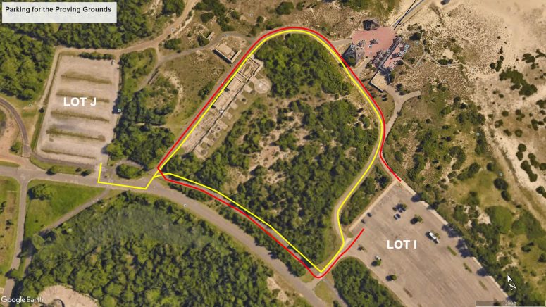
While weapons were removed, some structures were left standing, and the remnants can be seen today by taking a walk from Parking Lot I or J at the Sandy Hook Unit of Gateway National Recreation Area. Keep in mind that these are also beach parking lots and that from Memorial Day through Labor Day weekend there is a fee to park in them. If you don’t want to pay, use Lot M near the Nine Gun Battery and make the short walk over to the Proving Ground from there.
I was visiting North Beach at the time and had a parking permit, so I started out from Lot I (though Lot J is closer). I passed by the concession and restroom area for North Beach and then continued around the corner, thus coming from the northern end of the Proving Ground ruins. If you start at Lot J, walk out to the main road and take a left, then another left fifty feet farther and you’ll come in on the southern end.

Road from Lot I in the Sandy Hook unit of Gateway National Recreation Area passes the North Beach concession and bathhouse area
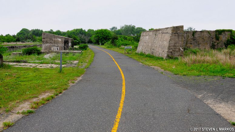
There are a few wayside exhibits along the road through the Sandy Hook Proving Ground, but not all of the ruins are identified. If you are walking south as I was, to the right is where the weapons and ammunition were stored, and to the left, where most of the ruins are located, is where the weapons were fired. This entire complex of structures was called the Proof Battery. There were many buildings on the Proving Ground, but they were torn down in the 1960s. All that remains today are some of the major concrete structures of the Proof Battery that were too much trouble to remove.
Before you even get to the bulk of the Proof Battery ruins, there is a dirt path that forks off to the right, passing between two L-shaped structures that look like two walls of a building. If you walk all the way to the end of the path, you will come out at the backside of Parking Lot J. However, before the parking lot are two concrete structures with a railroad track mounted on top of them. They are off the beaten path, so no wayside exhibits describe what they are, and I can’t even hazard a guess as to what they were used for. If you take this path, be sure to return the same way to the main road; do not cut across the field due to ticks.

Unknown structure with rail on top at the Sandy Hook Proving Ground, Gateway National Recreation Area

Unknown structures with rails on top at the Sandy Hook Proving Ground, Gateway National Recreation Area
The L-shape walls are actually concrete barriers call traverses that were built around ammunition magazines (buildings to store ammunition) to shield them in case of an explosion on the firing range. Notice how thick they are and that they taper up from the bottom like concrete barriers used for highway construction sites. They where L-shaped when built, so these are the entire structures, not just two remaining walls of former buildings.
The rest of the Proof Battery ruins are on the other side of the paved road. The most prominent features are two concrete structures with angled roofs that look like some sort of storage facility. These are actually more traverses that shielded the gun and ammunition storage area on the other side of the road from an explosion on the gun range. Why they appear to have doors that were sealed is beyond me. There were more than the two still standing today, for they ran the entire length of the gun range.

This side of the traverse faced the firing range of the Sandy Hook Proof Battery, Gateway National Recreation Area

This side of the traverse faced the gun and ammunition storage facilities of the Sandy Hook Proof Battery, Gateway National Recreation Area
There were gaps between the traverses so ammunition and weapons could be delivered to the firing range.

Gaps between traverses at the Sandy Hook Proving Ground allowed weapons and ammunition to be transported to the firing range, Gateway National Recreation Area
In between the traverses and the gun platforms is a channel with railroad tracks running down it. These tracks were used by a gantry crane that lifted heavy artillery pieces into place. The crane moved up and down the firing range on these tracks. In the photo below, the guns were mounted on the platforms to the left of the tracks. The traverses are the structures to the right.
You can still see the metal studs that were used to mount the carriages of the guns to the concrete.
There is one gun emplacement that looks like it was angled up so that a gun could shoot farther down range. This is not the case. Guns were all mounted on level platforms. The guns themselves angled up, not he platform. Perhaps when dismantling the Proving Ground after it closed, the military tried to remove this emplacement but decided that it was too much work and left it uprooted. In the photo below, notice how thick the concrete is.
When you get back to the main road, you can take a left either on the road or on the paved multi-purpose trail to get back to Parking Lot I, or a right to get to Parking Lots J, K, or M.
With a few exceptions, use of any photograph on the National Park Planner website requires a paid Royalty Free Editorial Use License or Commercial Use License. See the Photo Usage page for details.
Last updated on January 1, 2025


