

Cliffs along the Ocean Path at Acadia National Park
Length: 2.3 mile, one-way
Time: 1.5 to 2 hours with stops
Difficulty: Northern half is easy, southern half is moderate
If the criteria for Best Hiking Trail is being immersed in wonderful scenery with the least amount of effort, then the Ocean Path is hands down the best trail in Acadia National Park. Trails like the Beehive and Precipice have spectacular views, but these come few and far between, and you literally have to scale a mountain to get to them. On the Ocean Path, there are spectacular views of the Mount Desert Island coastline for nearly the entire length of the trail, and you barely have to break a sweat. Just don’t expect to be alone, for the trail is also one of the most popular in the park.

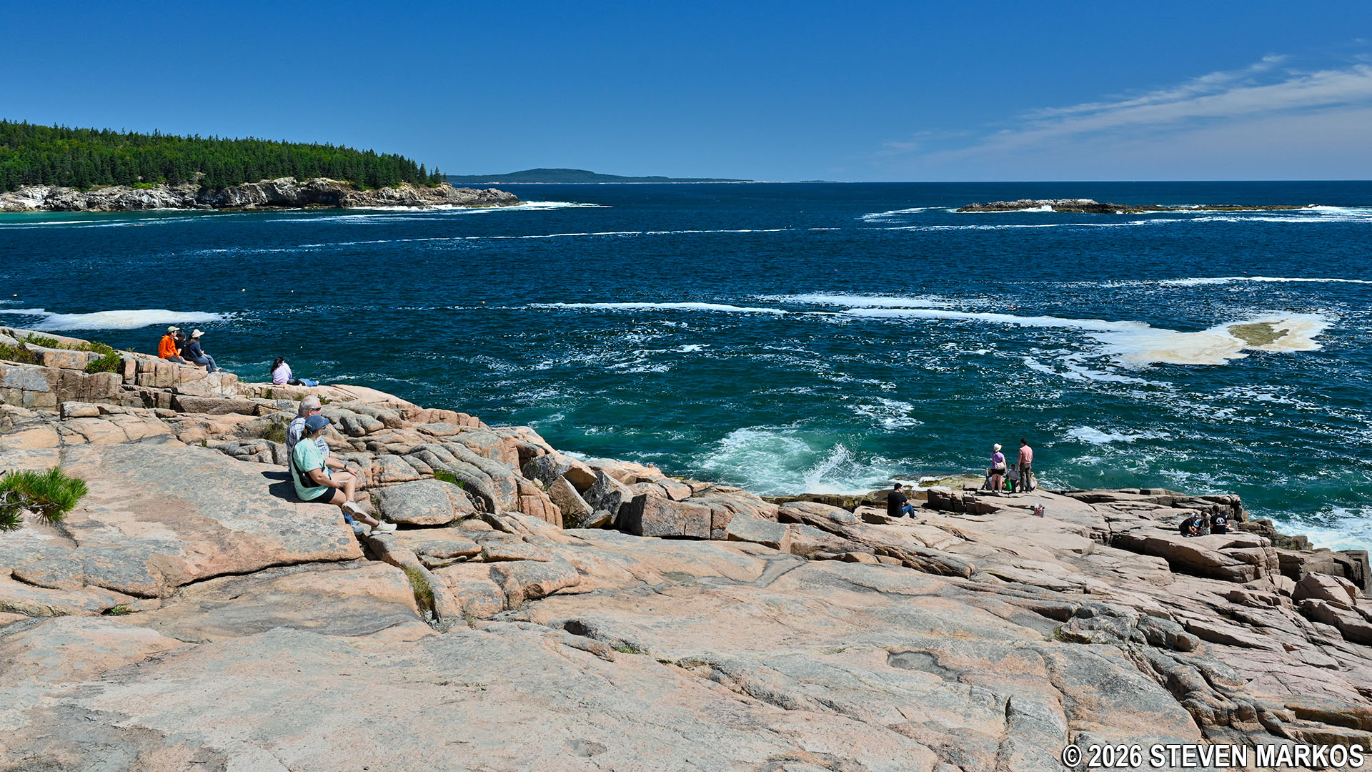
Typical view along the Ocean Path at Acadia National Park

View towards Acadia National Park’s Sand Beach
The Ocean Path runs along the southeastern coast of Mount Desert Island from the upper parking lot at Sand Beach to the parking lot at Otter Point. It is sandwiched between the Park Loop Road and the shoreline cliffs, and you’ll often find yourself walking right along the road, particularly on the northern end.

Ocean Path map (click to enlarge)

Northern end of Acadia National Park’s Ocean Path near Sand Beach
Deciding where to start the hike depends on how you arrive. The Ocean Path is an out-and-back trail, so if you drive, park at Otter Point and hike to Sand Beach. When done, catch the free Island Explorer Shuttle Bus back to Otter Point (the road is one way in the Sand Beach to Otter Point direction). Just be sure that you park in the correct parking lot, because there is also one for Otter Cliffs a third of a mile earlier, and I don’t believe the parking lots have names. The identifying characteristic of the Otter Cliffs parking lot is that it is located right where the road splits and a stone retaining wall separates the lanes. The Otter Point parking lot is the next one after the split. Also, Otter Cliffs has only one entrance, whereas Otter Point has an east and west entrance.
If you park at Sand Beach and walk to Otter Point, you can still catch the bus from Otter Point, but you must ride all the way around the Park Loop Road, and that takes an hour, about the same amount of time it takes to walk back if you don’t stop at any of the overlooks. Be sure to catch a bus that is heading to Bar Harbor and not to the Seawall Campground on the west side of the island.
If riding the bus to and hiking from Sand Beach, the bus lets off passengers in the lower parking lot. You must walk back towards the street and enter the upper parking lot, then walk all the way to the southern end—the same direction as the cars on the Park Loop Road are traveling—and you’ll run smack dab into the start of the Ocean Path. You’ll see some stairs that look like they lead to a trail, but these are just the stairs to Sand Beach.

Sand Beach trailhead for the Ocean Path at Acadia National Park
If parking at and walking from Otter Point, the trailhead is on the west side of the parking lot. Unless you miss the first turn into the lot from the Park Loop Road, you will be entering on the east side, so once parked, walk to the west side entrance and you’ll see the trailhead directly across the road. The bus stop is also located at the west entrance.

Otter Point trailhead for the Ocean Path at Acadia National Park
The Ocean Path is out in the open for most of the way, so wear a hat and apply sunscreen if avoiding the sun is important to you. Furthermore, during my late August visit the biting flies were a big nuisance, and I was told that fly season was over. The pests stay around your ankles, as if they know you can’t swat them easily down there. In my experience, insect repellent has no affect on them, but the problem is easily solved by wearing long pants.
I started from Sand Beach and will describe the hike from there. For the first 1.5 miles, the Ocean Path is an easy walk along a gravel trail. It’s not level, but any hills are negligible. However, it is not designated as an ADA trail because it does eventually head into the forest on rougher terrain, and oftentimes the gravel path is very narrow along the Park Loop Road, and a wheelchair may not fit.

Narrow section of the Ocean Path at Acadia National Park
While the Ocean Path itself is easy, there are many side trails that lead to overlooks on the edge of the cliffs that can be quite difficult. For example, a great view of Sand Beach—a tenth of a mile from the start—requires hiking off the Ocean Path and down steep grades over large rocks, and to reach Thunder Hole you must exit the trail and walk down stairs. These paths pop up every time you blink an eye, and if you walk down all of them you’ll never finish the hike, so there is no reason to take a side trail if you just went down one a hundred yards earlier. You’ll get the same view, just from a hundred yards farther south. And be careful, because people do get killed on these cliffs. A man trying to take a photo fell off a cliff in June 2016, and other lady fell in 2004.

View of Sand Beach from the Ocean Path at Acadia National Park

Stairs to Thunder Hole at Acadia National Park
Some of the side trails are overgrown with tall grass and other brush. Ticks are prevalent on Mount Desert Island, and the best way to pick one up is to walk through tall grass. However, for every overgrown side trail there are two that are wide open and on rocks, so stick to these.

Overgrown side trail along the Ocean Path at Acadia National Park

Open rock side trail along the Ocean Path at Acadia National Park
If the side trails are too much for you to handle, don’t worry, because there are views of the ocean and cliffs about fifty percent of the time from the main trail.

Views from Acadia National Park’s Ocean Path
View from the Ocean Path in Acadia National Park
For those of you who just want to sit on a cliff and watch the ocean, you can park anywhere along the trail in the right lane of the Park Loop Road.

Lady reading a book on the cliffs along the Ocean Path at Acadia National Park

Relaxing along the Ocean Path at Acadia National Park
Approximately 1.5 miles from Sand Beach, the Park Loop Road and the Ocean Path dart inland for a quarter mile before returning to the coast. It is at this point that the trail becomes moderate in difficulty as it passes over rougher terrain. Those who have trouble walking may want to turn back now, or just head out to the road and flag down a bus. If you do decide to turn back, you will have seen enough of the coast up to this point that a truncated hike won’t be a disappointment. It took me over an hour to walk this far, and this was all due to the fact that I couldn’t stop taking photos.

Terrain along the wooded section of the Ocean Path at Acadia National Park

Rough terrain along the wooded section of the Ocean Path at Acadia National Park
When the trail returns to the coast, you will find yourself facing a stone wall that runs along the 100-foot tall Otter Cliffs, the tallest eastern coastal cliffs in the United States. The retaining wall was built to keep vehicles from tumbling off, because at this point the road runs as close to the cliffs as possible. You can get onto some of the rocks below the wall, but there is no way to walk along the cliffs at this point. Instead, look for a stone staircase and take this up to the road to continue on the Ocean Path.

Below the stone wall at Acadia National Park’s Otter Cliffs

Painting the Otter Cliffs at Acadia National Park

Walled walkway along the Otter Cliffs on Acadia National Park’s Ocean Path

Otter Cliffs at Acadia National Park
Just past the Otter Cliffs, the Park Loop Road once again veers from the coast, but the Ocean Path continues to follow the shoreline beginning on what is the steepest section of the trail.

Steep section south of the Otter Cliffs of the Ocean Path at Acadia National Park

Views from the southern end of the Ocean Path at Acadia National Park
Near Otter Point, the very southern tip of the peninsula, the Ocean Path and Park Loop Road run side by side once again. There is a short walkway that connects to the road, and directly across it is the Otter Point parking lot. However, this connects to the center of the lot. The Ocean Path actually continues around the point for another .2 mile, ending at the west side entrance where the bus stop is located.
As you continue around the point you will get a glimpse of Otter Cove. You can walk down to near the shore, but the rocks are slippery, so be careful. I saw a lady loose her balance, but she managed to stay on her feet.

Otter Cove at Acadia National Park
The trail ends by climbing a small hill back to the road. As mentioned, this is the west entrance to the parking lot and the bus stop for the Island Explorer. If you plan to catch the bus, be sure that you get one that is heading to your destination, for buses serving three different routes stop here. They are just like city buses, complete with a number or destination sign on the front. You can pick up a printed schedule at the Hulls Cove Visitor Center, as well as at many other information centers in the park.
With a few exceptions, use of any photograph on the National Park Planner website requires a paid Royalty Free Editorial Use License or Commercial Use License. See the Photo Usage page for details.
Last updated on July 3, 2026


