
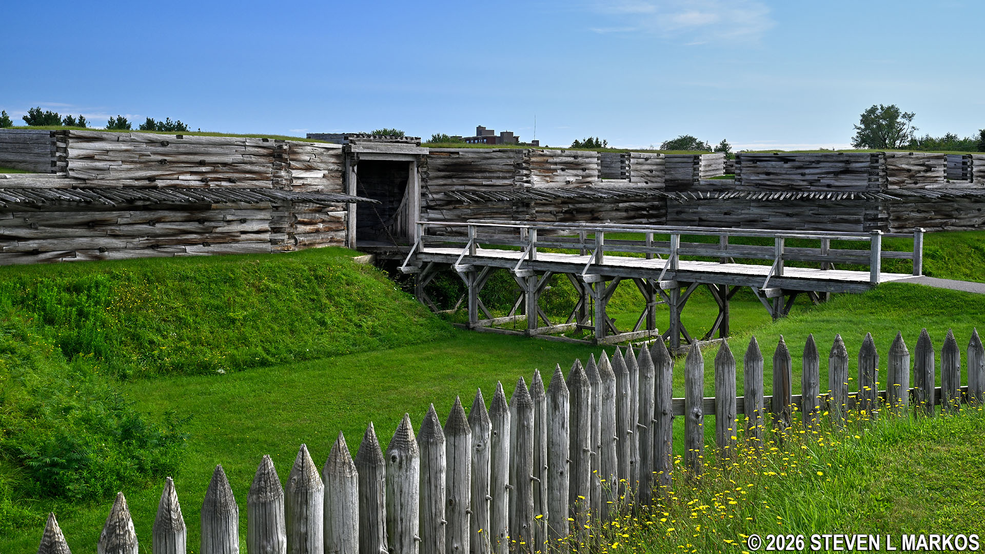
Reconstructed Fort Stanwix in Rome, New York, Fort Stanwix National Monument
The original Fort Stanwix was built in 1758 by the British during the French and Indian War (1754-1763) to protect what was known as the Oneida Carrying Place, a strategic portage between the Mohawk River and Oneida Lake. The easiest way to travel west to the Great Lakes from New York City was to sail north up the Hudson River on the incoming tide and then west on the Mohawk River towards Oneida Lake. From there it was possible to continue further west on the Oneida and Oswego rivers to Lake Ontario.
The only problem was that the Mohawk River ended prior to Oneida Lake, and there was a gap of anywhere from a mile to six miles, depending on water levels in the river. Travelers had to carry their boats and supplies by foot or by wagon (there were porter services) across this gap to Wood Creek, which connected to the lake. Thus, the country that controlled the Oneida Carrying Place controlled the quickest travel route from New York to Lake Ontario. (A short canal built in 1797 bypassed the Oneida Carry. This was eventually incorporated into the Erie Canal.)
At the start of the war, the British had two small forts protecting the Oneida Carrying Place: Fort Bull on the western end at Wood Creek (about three miles farther west than the eventual site of Fort Stanwix) and Fort Williams on the eastern end at the Mohawk River (a half mile to the southeast). Fort Bull, the smaller of the two, also served as the supply depot for three British forts at Oswego on Lake Ontario (Fort Oswego, Fort Ontario, and Fort George). These were the westernmost outposts for the army, and it was from Oswego that the British planned to launch an attack against the French at Fort Niagara farther west on Lake Ontario near Niagara Falls.
Forts Bull and Williams saw no action for the first 20 months of the war. Then, in late February 1756, the French attacked Fort Bull in order to cut off supplies to the British in Oswego, paving the way for their own attack on Oswego later that year. The battle took place on March 27th. Nearly everyone at Fort Bull was killed, and the fort and all its supplies were then destroyed by the French. A month later, the British began building a much more substantial fort at the Fort Bull site, Fort Wood Creek. A third fort, Fort Newport, was also built nearby.
In August, the French succeeded in capturing the British forts at Oswego and were rumored to be advancing towards the forts at the Oneida Carrying Place with 6,000 men. With Fort Wood Creek serving no more purpose as a supply depot, the British abandoned the area and moved east to German Flats (present day Ilion and Mohawk in Herkimer County). Before doing so, they destroyed all forts at the Oneida Carrying Place so that the French could not use them.
By the start of 1758, the British learned that the French planned to attack Albany, New York, by traveling down the Mohawk River. While nothing ever came of the plan, it did prompt the British army to reestablish itself at the Oneida Carrying Place (they were also able to reoccupy the Oswego forts since the French had abandoned them). It was at this time that a new fort was built under the direction of General John Stanwix with the consent of the Oneida Indians, the owners of the land. Its purpose was to be a staging point for attacks on the French. However, before it was even completed, the French had effectively been defeated in the west, so the fort was no longer strategically necessary. By 1761, only 50 men were stationed at Fort Stanwix. The fort itself was never attacked.

Model of Fort Stanwix being built in 1758 by the British on display inside Fort Stanwix, Fort Stanwix National Monument
The British were victorious in the war, and France forfeited all of its territory east of the Mississippi River to the British. The Indians previously allied with the French, however, were not happy with the results, and in May 1763, various tribes of the Great Lakes region began a war against the British army and the colonists who had settled on their lands (Pontiac’s Rebellion, named after the Ottawa chief, Pontiac). The British were able to subdue the attacks by the fall of 1764. In addition, King George III signed the Proclamation of 1763 forbidding any colonist to settle west of the Appalachian Mountains, thus allowing the Indians to live peacefully on the lands to the west.
There were many British settlers already in the west when the Proclamation was signed, and none were happy about having to give up their land. With tensions between the colonists and England already beginning, the Proclamation was largely ignored, and settlers continued moving westward. This of course caused more conflicts with the Indians.
When building Fort Stanwix, the deal with the Oneida included removing the fort when the war was over. However, due to continued hostilities with the Indians, the British did not honor that part of the bargain. However, very little money was spent on the fort’s upkeep, and by 1764 it was in poor condition. In July, the British did begin a renovation project, and the worst of the fort was repaired over the next year.
The Proclamation of 1763 did not forbid the colonial government from negotiating new treaties with the Indians that moved the boundary westward, and Fort Stanwix was where one such treaty was signed, aptly named the 1768 Treaty of Fort Stanwix. This was the last major event in the history of the fort until the American Revolution began. It was once again falling apart, so in order to cut expenses, the British decided to abandon it altogether and let nature take its course.
With the commencement of fighting in April 1775 between the British and the rebelling colonists known as Patriots, General Philip Schuyler, commander of the Northern Department (northern New York), urged the Continental Congress to reoccupy the Oneida Carrying Place due to its military value. He negotiated another deal with the Oneida Indians, and in July 1776, the 3rd Regiment of New Jersey moved into the area with the task of either rebuilding the old fort, which was largely in ruins, or constructing a new one. It is not known for certain which option was chosen, but historians believe that in order to have a fort ready by winter, it would make more sense to rebuild the original fort on its existing location. Extant drawing from the time confirm that the new fort was built (or renovated) on the same site, and a letter from Schuyler to George Washington used the word “repairing” in reference to the progress of construction.
While work on the fort continued into the spring of 1777, which included major changes, it was substantial enough to make it ready for defensive purposes by the end of August (which also points to renovation instead of new construction). The fort was officially named Fort Schuyler, but everyone continued to call in Fort Stanwix despite the name being that of a British officer.
In June 1777, British general John Burgoyne began a march south from Montreal through Lake Champlain with intentions of capturing Albany so to isolate New England from the rest of the colonies. In the meantime, Lieutenant Colonel Barry St. Leger was to create a diversion by marching from Fort Oswego on Lake Ontario with roughly 2,000 men, half British, German, and Canadians and half Indians of the Iroquois nations. Troops under the command of General William Howe would march from New York City, which was already under British control. All three would converge on and capture Albany. Unfortunately, none of them made it (Howe never even started), and Burgoyne was defeated at Saratoga, a village just north of Albany.

Map of General John Burgoyne’s march towards Albany
St. Leger departed Oswego on July 26th. His route took him directly to Fort Stanwix. British intelligence informed him that the fort was manned only by 60 men when in fact there were 800. Ill-prepared to capture the fort, he began a siege on August 3rd with hopes of starving the men into surrender. When word came that General Benedick Arnold was on his way with reinforcements, St. Leger decided to retreat, and the siege ended on August 23rd. His failure to join with Burgoyne was certainly a major factor in the British defeat at Saratoga.
The Siege of Fort Stanwix was the only action the fort saw during the war. Its only other moment of significance was at the end during the peace process. The 1783 Treaty of Paris was only between the new United States of America and England. The tribes of the Six Nations of the Iroquois—Mohawk, Oneida, Onondaga, Cayuga, Seneca, and Tuscarora—that fought against the United States had to negotiate a separate treaty. This was done at the site of Fort Stanwix in October 1784. The fort itself had been so severely damaged by fire on May 13, 1781—arson was suspected—that it was never rebuilt. In 1830, what remained of Fort Stanwix was leveled.
The city of Rome grew up around (and on top of) the old fort site. Its citizens always considered Fort Stanwix to be an important part of American history, so a campaign began in the early 1920s to have the federal government officially recognize its significance, which would ultimately boost tourism to the city. Their efforts paid off when in 1935 the United States Congress authorized the creation of Fort Stanwix National Monument, though no funds were set aside to develop the site. The land or the money to purchase the land where the fort was located had to be donated to the federal government, and thus nothing further was done. In fact, the exact location of the fort was not even known with certainty (though everyone had a good general idea of where it was).
It wasn’t until 1965 when the city of Rome received funding for an urban renewal project that the development of a Fort Stanwix attraction moved forward. An archeological excavation that same year had revealed the fort was where everyone thought it was, and with the money, the city purchased the 16-acre fort site and began the removal of roughly 70 existing buildings standing on the property. The National Park Service prepared a master plan for the park’s development, and in 1969 it was announced to the public that Fort Stanwix would be rebuilt.
Detailed maps and construction plans for Fort Stanwix still existed, and these showed the basic location and layout of the fort. What remained was to find the footprint so that existing ruins, if there were any, could be matched up with the drawings. This was accomplished during another excavation between 1970 and 1972 by the National Park Service. With the drawings and the footprint, the new fort could be built exactly where the original was located. However, what the actual buildings looked like (windows, doors, etc.) or what they were used for was left to speculation. What stands today is the best reconstruction possible based on the historical and archeological information, though it is certainly not one-hundred-percent accurate. In fact, four known structures were not reconstructed—the headquarters and guardhouse inside the fort and the ravelin and necessary (privy) on the outside of the fort.
The land was donated to the National Park Service in 1973. Construction on Fort Stanwix began in 1974. On May 20, 1976, the new park was opened to the public, just in time for the July 4th Bicentennial Celebration that year.
With a few exceptions, use of any photograph on the National Park Planner website requires a paid Royalty Free Editorial Use License or Commercial Use License. See the Photo Usage page for details.
Last updated on January 20, 2026


