

Brawner Farm Loop Trail Map (click to enlarge)
Note: The trails at Manassas National Battlefield Park are poorly marked, so be sure to bring a trail map with you for navigation purposes. The best is the Trail Guide, a tri-fold map that is free at the Henry Hill Visitor Center. For planning purposes, you can download the map here, but be sure to pick up a full-color version before you begin your hike.
Manassas Trail Map (PDF)
Length: 1.4-mile loop
Time: 1 hour
Difficulty: Mostly easy with a small hill at the start
The Brawner Farm Loop Trail at Manassas National Battlefield Park circles the area where the Second Battle of Manassas began on August 28, 1862. From the Brawner Farm parking it is a five-minute walk to the actual farm site. You will be approaching the farmhouse from the back, so walk to the front where you will find a dirt road with distinct tire tracks worn into the ground. This is the original road that runs south from the farmhouse to Highway 29, which at the time of the Civil War was called the Warrenton Turnpike.

Original road that leads from the Warrenton Turnpike to Brawner Farm, Manassas National Battlefield Park
Look across the road and you will see a swathe cut through the tall grass. Though nothing identifies it as the Brawner Farm Loop Trail, this is the trailhead that sets you off hiking in a counterclockwise direction, the way the trail was meant to be hiked. The trail begins by heading up a small hill, but after that the terrain is fairly level. After all, this was once a farm.

Start of the Brawner Farm Loop Trail in Manassas National Battlefield Park
Nearly all of the Brawner Farm Loop Trail is out in the open and exposed to the sun, so if avoiding the sun is a concern to you, be sure to wear a hat and sunscreen. There are a few wooded areas, but these do not amount to more than a quarter mile of the trail’s 1.4-mile length.
Most of the trail is a mowed grass path, a favorite environment for ticks. While I didn’t pick up any on this hike, I did on some of the other trails. I suggest wearing long pants treated with Permethrin when hiking anywhere in the park.

Typical terrain of the Brawner Farm Loop Trail in Manassas National Battlefield Park
A feature of the trails in Manassas National Battlefield Park is wayside exhibits that contain eyewitness accounts from men who fought in the battle. As you hike out on the southern half of the Brawner Farm Loop Trail you are walking along the Union battle line, and you will find waysides with quotes from Union soldiers. When you return along the northern side of the trail you will find quotes from Confederate soldiers, for this was the Confederate battle line. These aren’t quotes from generals or important historical figures, but from average soldiers who survived the war. Be sure to read these, for they are most interesting.

Wayside exhibit with a quote from a Union soldier, Private Nathaniel Rollins, along the Brawner Farm Loop Trail in Manassas National Battlefield Park
You don’t get five minutes down the trail before coming to a lone tree at an unmarked intersection with a mowed grass path that goes to the left, cutting over to the north side of the trail. This is a path used by park Rangers when giving guided tours of the battlefield. The tour only comes this far along the Union battle line before heading over to the Confederate line near a display of artillery. Those hiking the Brawner Farm Loop Trail should keep straight ahead.
A few minutes beyond the Ranger trail is an intersection with a bridle trail, though this is unmarked. Also in this same vicinity is the first sign that confirms that you are indeed on the Brawner Farm Loop Trail: a plastic post with a blue dot on it. Posts with blue dots mark hiking trails while those with yellow dots are for bridle trails (which are open to hikers as well).

Posts with a blue dot mark hiking trails at Manassas National Battlefield Park
In a quarter mile the trail comes to a strip of forest. It doesn’t take long to pass through it, and once back out into the sunshine you will find yourself walking along a narrow stand of trees to your left and a field on your right (see the map at the top of this page). These trees are actually growing along a very small stream, one with a flow of water so little that it is more like a wet area. This water is the source of two mud holes, the first coming just after you exit the forest (it could be dried up if there hasn’t been any rain). To get around it, people have been hiking through the tall grass that lines the trail. If forced to do this, be sure to double-check yourself for ticks.

Mud hole near the grove of trees at the south-central section of the Brawner Farm Loop Trail in Manassas National Battlefield Park
Just beyond the mud hole is an intersection with another unmarked trail. I have no idea what this is, but it is not a bridle trail and it is not on the trail map. A satellite image shows tire tracks, so maybe it is some sort of utility road used by the National Park Service. Taking a left cuts over to the Confederate side of the trail, while a right leads down to Highway 29. Keep straight to remain on the Brawner Farm Loop Trail.
The far end of the loop comes .6 mile into the hike. The trail curves around to the left and passes through the stand of trees to a field on the other side. It does so along a boardwalk that spans the small stream. This is the first time you become aware that a water source even exists.

Boardwalk through the narrow strand of trees at the southeastern end of the Brawner Farm Loop Trail in Manassas National Battlefield Park
Instead of turning left over the boardwalk, you also have an option to take a right on a trail that heads south. This is a connector trail to Battery Heights, the second stop on the Second Manassas Battlefield Automobile Tour. The trail heads up and over a hill before continuing towards Highway 29.

Connector trail to Battery Heights at the southeastern end of the Brawner Farm Loop Trail in Manassas National Battlefield Park
Once across the field, the Brawner Farm Loop Trail dead ends into a T-intersection. Take a left to head back to the farmhouse. The trail to the right is another connector trail, this one to the Deep Cut Loop Trail.
As you make your way back on the north side of the Brawner Farm Loop Trail, you are now walking along the Confederate battle line. Notice that the signs have quotes from Confederate soldiers. (Union signs have a blue border; Confederate signs have a red border).

Wayside exhibit along the Brawner Farm Loop Trail with a quote from a Confederate soldier, Manassas National Battlefield Park
As you will find, the Brawner Farm Loop Trail is nothing more than a long, narrow oval, so when you hike back you are no more than a couple hundred yards from where you were on the way out. You’ll pass the same trail intersections and through the same grove of trees. Remember the mud hole on the other side? You have one here too—depending on the rainfall—only this time there is no way around it due to the thick brush on either side of the trail. When I did my hike, the mud was deep enough to come up to the top of my boots. A hiker who was behind me turned around and went back the way he came—hopefully he knew about the cut-through trail back to the south side.

Mud hole on the north-central side of the Brawner Farm Loop Trail in Manassas National Battlefield Park
Just after exiting from the forest is the intersection with the bridle trail—this side is marked with a sign—and ten minutes farther ahead is a display of Confederate artillery. These cannon mark the spot of an artillery battery that was set up on August 30, 1862, the final day of the Second Battle of Manassas. The guns were used to shell Union soldiers attacking Stonewall Jackson’s men at the Deep Cut. While trees block the view today, this was all open fields in 1862. Union soldiers had to march a quarter-mile across these fields, all the while being shot to pieces by cannon and musket fire. Needless to say, the attack was a failure.
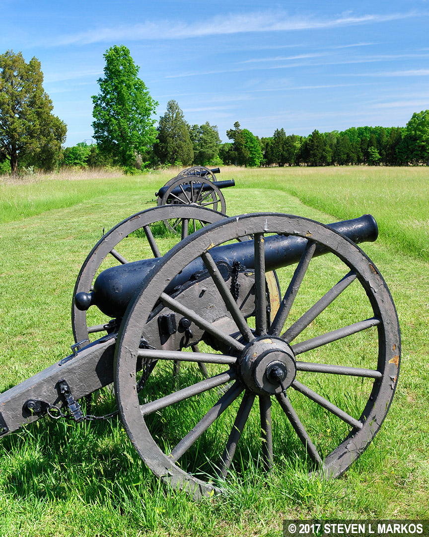
Battery of Confederate artillery located along the Brawner Farm Loop Trail in Manassas National Battlefield Park

Cannon near the Brawner Farm aims at Deep Cut, Manassas National Battlefield Park

Battle map showing Confederate lines when the Union attacked at Deep Cut (rotated to a north orientation)
A mowed path from the artillery exhibit leads down to a fence that marks the Confederate line when close fighting began on the first day of the battle, August 28th, at around 6 PM. When the Confederates open fired on Union soldiers marching along Warrenton Turnpike on their way to Centreville, only the cannons could be seen from the road. The bulk of the army was farther back on Stoney Ridge and hidden from view. Thinking that the entire force was but a few artillery pieces and crew, Union General John Gibbon sent the 2nd Wisconsin Infantry charging up the hill towards the guns. At that moment, General Stonewall Jackson’s famed Stonewall Brigade appeared on the hill, surprising the Union soldiers. Though the Confederates numbered only 850 men as compared to the nearly 2,000 that Gibbon commanded, they were some of the best soldiers in the battle. Once close fighting ensued, the fence is where the Confederates took up position. The southern side of the Brawner Farm Loop Trail marks the Union position.

View of the Confederate line at the Brawner Farm—fence at the top of the hill—from the Union perspective, Manassas National Battlefield Park
To get back to the farmhouse from the artillery exhibit, look for a path that cuts through another narrow stand of trees. From there it’s just a few minutes back to the house.

Back at the Brawner Farmhouse, Manassas National Battlefield Park
When I am hiking in a historical park such as Manassas National Battlefield Park, I don’t care much about scenery, but I do like the trails to add to the historical perspective of my visit. With the wayside exhibits and the placement of the Confederate artillery battery, a hike on the Brawner Farm Loop Trail gave me a better understanding of the initial fighting at the Second Battle of Manassas because I could now see the terrain with my own eyes. When you read about how being positioned on Stony Ridge gave the Confederates an advantage, it’s all just words, but when you stand where the Union soldiers were and look up at the Confederate line, you now understand the difficulties of the battle. I highly recommend this short and easy hike when you stop for a visit at Brawner Farm.
With a few exceptions, use of any photograph on the National Park Planner website requires a paid Royalty Free Editorial Use License or Commercial Use License. See the Photo Usage page for details.
Last updated on May 14, 2025


