

Upper Delaware Scenic and Recreational River between Narrowsburg and Ten Mile River in New York
Length: 5.5 miles
Water Level at Time of Trip: 1.3 to 3.1 feet
Average moving speed: 3.5 MPH with two paddlers
Time: 1.5 hours
This river review covers the Delaware River from the Pennsylvania Fish and Boat Commission Boat Ramp across the river from Narrowsburg, New York, to the Ten Mill River Canoe Launch, a span of 5.5 miles. If you start from the New York DEC Boat Ramp in Narrowsburg, add a half mile to the journey. Both boat ramps are made of concrete and can accommodate motorized and non-motorized boats.

Pennsylvania Fish and Boat Commission boat ramp at Narrowsburg, Upper Delaware Scenic and Recreational River
Before starting a trip on the Upper Delaware Scenic and Recreational River, it is a good idea to check the water levels so that you have an idea of the river conditions. Levels of 2.5 to 4 feet are average and provide plenty of water for a trip down the river with conditions suitable for paddlers of all skill levels. The two relevant water gauges for the Narrowsburg-Ten Mile River section of the river are at Callicoon, New York (14 miles upriver from Narrowsburg), and just north of Lackawaxen, Pennsylvania (13 miles downriver from Narrowsburg). These cover a span of 26 miles, so you’re not going to get readings you can bet your house on, but you’ll have a good idea of whether you are in for an enjoyable outing or if you’ll be dragging your boat over rocks most of the time (or risking your life when water levels are high).
On the day of my trip, the Callicoon gauge reported water levels of 1.3 feet, which is low but typical of that gauge. The actual measurements are taken at the Callicoon Bridge where Callicoon Creek empties into the Delaware River. This reading was in the ballpark for a few miles upriver from the bridge, but downriver the water levels were much higher (the Lackawaxen gauge read 3.15 feet the same day). At this point on the river, I’d give more credence to the Lackawaxen gauge than the one at Callicoon. Keep in mind that all observations in this report are based on the above mentioned water levels, so adjust your expectations according to the conditions on the day of your trip.
The Pennsylvania boat ramp is situated on what is essentially a lake, so if you don’t paddle, you don’t move. In fact, this is the only spot within the boundary of the Upper Delaware Scenic and Recreational River where water skiing is allowed. However, the channel narrows not too far downriver from the Pennsylvania boat ramp and the current picks up a bit. There are even some small rapids as the Delaware River curves around a large bend and begins a long, southeast trajectory towards Ten Mile River.

Small cove at Narrowsburg on the Upper Delaware Scenic and Recreational River

Small rapids just downriver from the Pennsylvania boat ramp at Narrowsburg, Upper Delaware Scenic and Recreational River
When I went down the Upper Delaware Scenic and Recreational River in late October, there was an eel weir in operation 1.25 mile past the Pennsylvania boat ramp. An eel weir is a V-shaped rock dam that funnels eels into a wooden trap at the nadir of the V on the downriver end. Permits are issued to build the trap and catch eels starting in late summer, and the trap remains in place up through the fall (the rocks are always there). When the trap is in place, boaters have to pass the eel weir either on the far left or the far right to get around it. I went to the right, and there wasn’t much water. I made it through, but only after scrapping bottom numerous times (this was the only shallow area on this section of the river). I don’t know if going around the weir to the left would have been any easier, but it couldn’t be much worse. On the plus side, the current was pretty fast through this area—3 MPH.

Eel weir on the Delaware River south of Narrowsburg, Upper Delaware Scenic and Recreational River
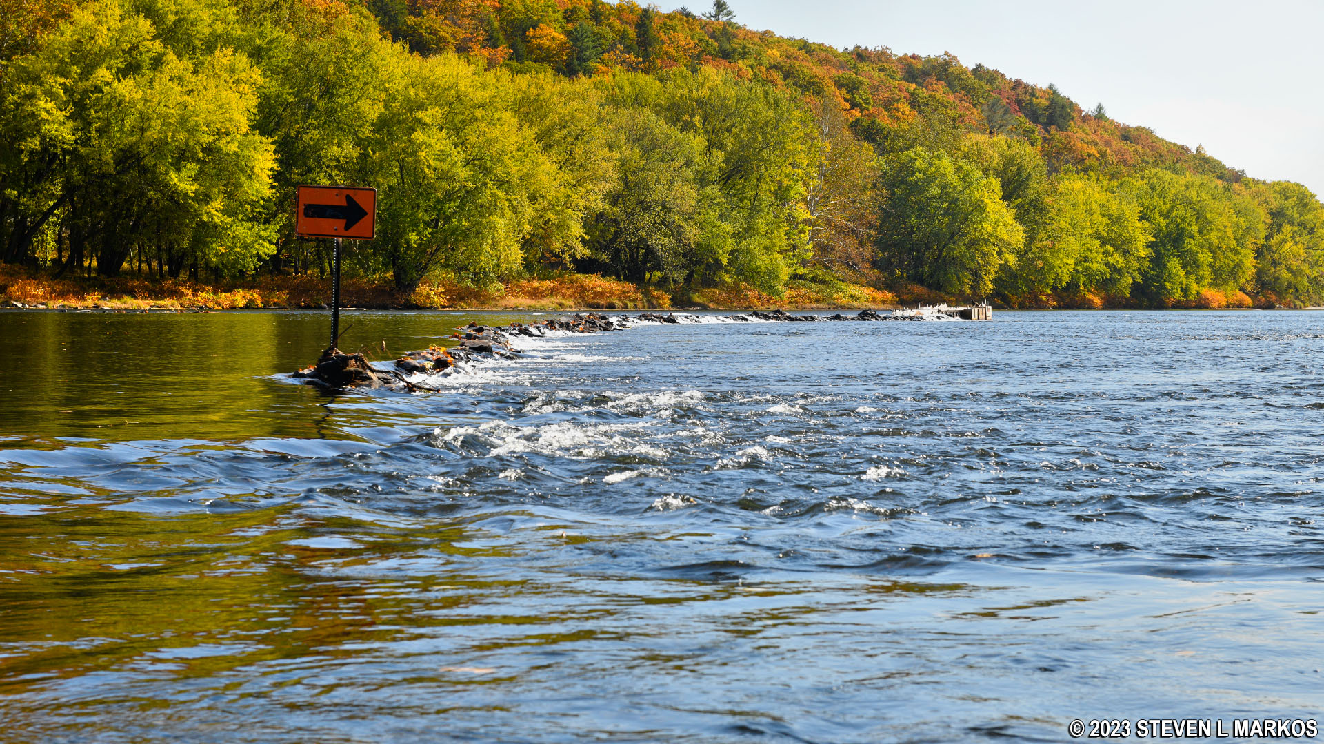
Eel weir on the Delaware River south of Narrowsburg, Upper Delaware Scenic and Recreational River

Trap of the eel weir on the Delaware River south of Narrowsburg, Upper Delaware Scenic and Recreational River
For the next mile past the eel weir, the Delaware River moved along pretty well, and there were a couple of minor rapids to make things a little fun.

Small rapids on the Delaware River south of Narrowsburg, Upper Delaware Scenic and Recreational River
Four-and-a-half miles into the trip is the Tusten Station Railroad Bridge, and as soon as you go under there is a nice .1-mile stretch of small rapids. There is nothing dangerous at normal water levels, even for small kids, but you might get splashed a little. These weren’t as big as the rapids just below Skinners Falls, but they still add a little excitement to the journey.

Tusten Railroad Bridge spans the Delaware River south of Narrowsburg, Upper Delaware Scenic and Recreational River

Rapids at the Tusten Railroad Bridge south of Narrowsburg, Upper Delaware Scenic and Recreational River
The Ten Mile River Canoe Launch is a little over a mile downriver from the railroad bridge. Just prior to it is the confluence of the Delaware and Ten Mile rivers. On the day I did the trip, the Ten Mile River wasn’t anything more than a small creek.
The Ten Mile River Canoe Launch is on the New York (left) side of the Delaware River, just a tenth of a mile past the confluence with Ten Mile River. It is a large beach area with plenty of places to launch your boat. There is a paved parking lot, making this a convenient spot to start or end your trip. However, the shoreline is very muddy. In fact, this is a geological feature of this area that is caused by sediments in the water dropping to the bottom when the faster moving water of Ten Mile River empties in to the slower moving Delaware River. I sunk up to the tops of my ankles when getting out of my kayak. Depending on the amount of rain, the mud can be as deep as a foot and a half. Because vehicles and boat trailers can get stuck in this mud, the Ten Mile River launch is for hand-paddled watercraft only and not motorboats.
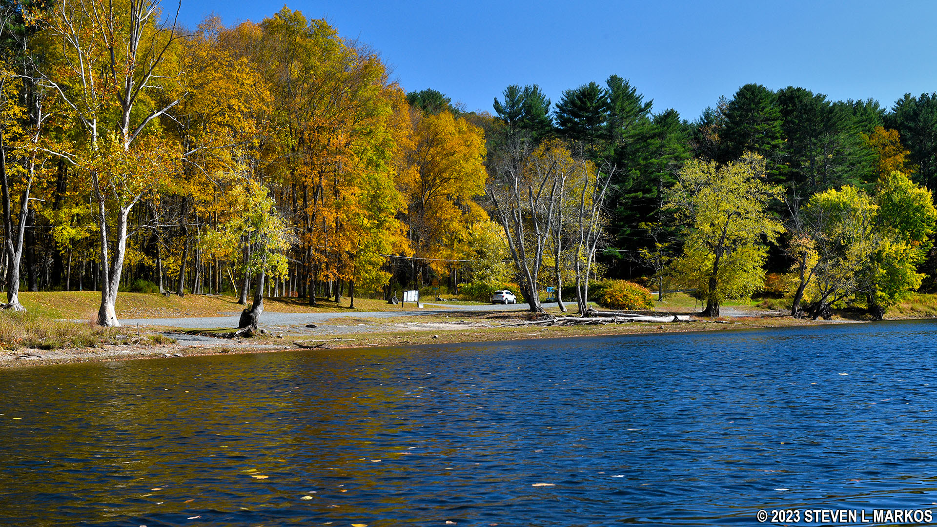
View of the Ten Mile River Canoe Launch from the Upper Delaware Scenic and Recreational River
Next River Section | Previous River Section | River By Section Home Page
With a few exceptions, use of any photograph on the National Park Planner website requires a paid Royalty Free Editorial Use License or Commercial Use License. See the Photo Usage page for details.
Last updated on August 17, 2023


