

Lower Delaware National Wild and Scenic River at the Lambertville Wing Dam
RIVER TRIP OVERVIEW
Lambertville, New Jersey, to Washington Crossing Historic Park
Length: 6.8 miles
Water Level at Time of Trip: 1.6 to .15 feet
Average moving speed: 3.9 MPH with two paddlers
Top Speed: 5.5 MPH
Time: 1.75 hours
This review covers a trip on the Delaware River from the Lambertville Boat Ramp in Lambertville, New Jersey, to the canoe launch at Washington Crossing Historic Park in Pennsylvania. Although the official southern boundary of the Lower Delaware National Wild and Scenic River is a half mile downriver from the canoe launch, this is the last take-out location within the park. The next public boat ramp is the Yardley Boat Ramp 3.5 miles away.
This entire trip is within the boundary of the Lower Delaware National Wild and Scenic River. I mention this because sections of the river can be excluded due to excessive shoreline development, poor water quality, or because a municipality along the river does not want to be part of the park. Decisions not to be included are often based on the fact that the municipality may have to impose stricter regulations on the businesses along the river.
THE FINE PRINT
Before starting a trip down the Lower Delaware National Wild and Scenic River, always check the water levels so you have an idea of the river conditions. The most relevant United States Geological Survey (USGS) water level gauges for this trip are at Lambertville and Washington’s Crossing. On the day I did the trip in mid-October, the Lambertville gauge reported 1.6 feet of water and the Washington Crossing gauge .15 feet. Yes, you read that correctly. Point one five feet. In fact, by the end of the day it read -.15 feet. Minus? How is that possible? Historically the gauge at Washington Crossing rarely reports water levels over a foot and often reports negative numbers, so I’m not exactly sure where it is positioned or what it is measuring because there was plenty of water in the river near Washington Crossing, and I’m not talking about just enough to get by. I’m talking about not being able to see the bottom.
Water level gauges only measure depth at one location, and the measurements are relative to the area. Case in point, .15 feet of water at Washington Crossing means there is plenty of water in that area, whereas if the Lambertville gauge reported .15 feet, the river in that area may well be dry. Likewise, 1.6 feet of water at Lambertville is plenty of water for that area. If the USGS gauge at Phillipsburg farther upriver reported 1.6 feet, you could be scraping the bottom of the riverbed in that area quite often. Ultimately, you need to know the minimum amounts of water required for a particular segment of the river in order to avoid getting stuck in shallow water.
I’m from Georgia. I went down the Lower Delaware National Wild and Scenic River once, so I do not know what water levels may require advanced paddling skills or may even be dangerous, or at what levels you may be scraping the bottom of the riverbed. All I can say is that with 1.6 feet of water at the Lambertville gauge and .15 feet at Washington Crossing, there was plenty of water in the Delaware River for an enjoyable paddling trip. The observations in my report are based on these water levels. If you do the trip when the levels are significantly lower, you may be dragging your boat to deeper water in some places and probably won’t experience the same degree of rapids as reported. If the water levels are significantly higher, you may experience more intense rapids, and more of them. Also be aware that regardless of water levels, extreme winds can cause turbulent conditions that require advanced skills on water otherwise suited for all paddlers.
RIVER TRIP DETAILS
A quarter mile from the Lambertville Boat Ramp is the Lambertville Wing Dam, and here you will encounter the only serious whitewater section within the boundary of the Lower Delaware National Wild and Scenic River. To put this into perspective, I took photos while going through just about every rapid on the Delaware River from Hancock, New York, to the Lambertville Boat Ramp (I was paddling with a friend in a two-man kayak, so there was somebody steering the boat). These photos were taken with $5,000 worth of camera equipment, and I don’t use a strap on my camera when going down a river. That means I’m pretty sure that I’m not going to drop it in the water when going through rapids, and some of these were Class II. I don’t have any photos going through the Lambertville Wing Dam. In fact, my camera was sealed inside a waterproof case and attached with bungie cords to the kayak just in case we got flipped over. So, the wing dam is definitely in a class by itself.
If you are thinking, “Well, I just went through the Bulls Island Wing Dam and that was nothing,” this is not the same. I don’t know enough about the area to explain why, but the Lambertville Wing Dam is not for beginners or even paddlers with some experience and who are skittish. This is not to say that you need whitewater experience. I’ve kayaked over 250 miles for National Park Planner, and my whitewater experience is limited to the Upper, Middle, and Lower Delaware rivers up to the Lambertville Boat Ramp, which is not saying much because other than perhaps a half dozen rapids, anyone can paddle down these rivers. I went through the Lambertville Wing Dam without a problem, but I have a good knowledge of reading currents, I know how to maneuver a boat quickly around objects, I am somewhat athletic, and I have a sense of adventure.
However, the key to my success is that my buddy and I scouted the rapids the day before and figured out the easiest way through. I highly suggest doing this if you are thinking about running the rapids for the first time but aren’t quite sure. You can walk right out on the dam—assuming it is not underwater—and you’ll know pretty quicky if it is for you. Park at the end of Mt. Hope Street in Lambertville and walk to the dam on the Delaware and Raritan Canal Trail.
Checking out the rapids on the Lower Delaware National Wild and Scenic River at the Lambertville Wing Dam
So what is a wing dam? These dams were built in the canal days to back up the river in order to create a pool of water that could then be fed into the Delaware Canal on the Pennsylvania side of the river and the Delaware and Raritan Canal on the New Jersey side. These dams are shaped like the wings of an airplane, only there is a hole in the middle where the fuselage of the plane would be. I suppose the hole is how “THEY” get away with the claim that the Delaware River is the longest free flowing river in the eastern United States.
Over the years, the wing dams at Bulls Island and Lambertville on the Lower Delaware River deteriorated. Part of the Lambertville dam had even washed away, leading to the degradation of the lake it had created that was, in modern times, a source of recreation that brought in a lot of money to the area. In the mid-1960s, the Pennsylvania government approved a renovation project, and the dams were rebuilt, with a few changes. For example, the Lambertville dam was built a little taller, and the gap in the middle was narrowed by 150 feet. This would let less water pass through, thus creating a larger lake by causing more water to pool behind it. The Lambertville project was completed in 1968.
I do not know how tall the dam is or how high the water must be for the dam to be underwater, but it does happen. All I can say for sure is that it is not underwater when the Lambertville gauge reports 1.6 feet of water. The satellite images below show the differences in the dam during periods of low and high water.

Lambertville Wing Dam exposed at low water

Lambertville Wing Dam underwater
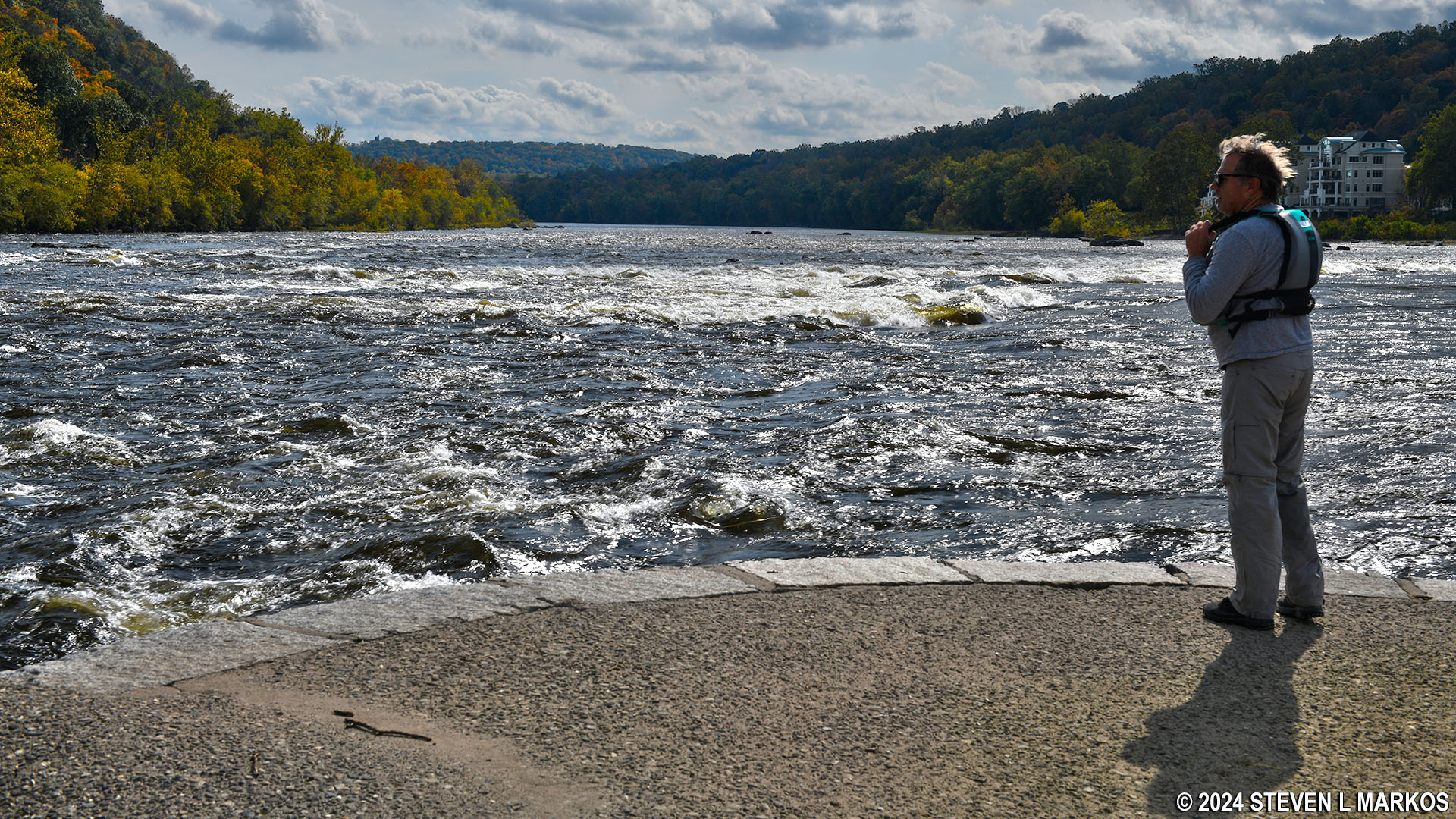
When you pass the Lambertville Boat Ramp, head over to the New Jersey (left) side of the river because this is where you want to be—trust me. The dam is low to the water, so it is hard to see until you get right up on it, though you can hear the rushing water from far away.

Approaching the Lambertville Wing Dam from the New Jersey side of the Lower Delaware National Wild and Scenic River
If the dam is exposed and not underwater, you can pull right up to it and get out and walk around. In fact, even if you came the day before, you should still scout out the rapids to see if anything changed.

Resting at the Lambertville Wing Dam on the Lower Delaware National Wild and Scenic River
In the satellite image below, notice the island next to the New Jersey shore and the narrow channel between the two. The water in this channel is free of rapids, so if you get to the dam and chicken out, you can just pull your boat over the dam (or float over if the water is high enough) and continue down the river through this channel. Keep in mind that when you get to the downriver end of the island and back out into the main river channel that there are still .3 mile of Class I and II rapids awaiting you. However, these are a lot smaller than the ones you face when going through the dam.

Satellite view of the Lambertville Wing Dam

Narrow channel on the Lower Delaware National Wild and Scenic River between a small island and the New Jersey shore at the Lambertville Wing Dam
If you don’t want to have anything to do with the Lambertville Wing Dam or the rapids downriver from the dam, and you already passed the Lambertville Boat Ramp, you can get out at the dam—assuming it is not underwater—and haul your kayak up to the Delaware and Raritan Canal and just paddle down it to the next river boat ramp at Fireman’s Eddy. To do so, once on the dam, walk to the shore and you’ll see a steep and rocky path that leads up to the canal. It’s not going to be easy getting up it, but that’s your only option. Once on the canal, paddle until you come to the first bridge over the canal. Get out there and carry your boat 150 yards to the Fireman’s Eddy Boat Ramp and continue down the Lower Delaware National Wild and Scenic River from there.

Path from the Lambertville Wing Dam to the Delaware and Raritan Canal
If you decide to go through the dam, the amount of water is going to determine which way to go. Watch the two videos below. The first I shot just before going through the rapids. The second was shot when the water was much lower—it doesn’t even look like the same river. All the rocks you see in the second video that run parallel to the dam towards the New Jersey shore and the island, they weren’t even visible when I was there.
If you look at the satellite images, most of the whitewater is located in the middle and to the left side (Pennsylvania) of the gap in the dam. This turbulence is caused by a large field of boulders. This is where you’ll see very experienced kayakers “surfing” these standing waves. If that is what you want to do, this is where you need to go.

Boulder field at the Lambertville Wing Dam on the Lower Delaware National Wild and Scenic River
If you are like me and just want to get down the river, most likely you will want to stay away from the boulders. When my buddy and I scouted the rapids, we noticed that the current curved around the New Jersey side of the dam and headed towards the island, then naturally curved away from the island and continued downriver, essentially forming an S-curve. So that’s what we decided to do. See the satellite image below for our course.

Course through the Lambertville Wing Dam
We made it through the dam and down the river without any problems except for one: we forgot to take the drain plugs out of our kayak. Going through the dam, and even going downriver through the ensuing rapids, you are going to get splashed, and that’s putting it lightly. Swamped is more like it. We were literally sitting in what amounted to a bathtub all the way down the rapids. The only reason the boat didn’t sink is because it was an inflatable. On top of that it was 40 degrees out in mid-October. So don’t make that mistake if you are in an open boat. There is a landing area on the shore at the end of the rapids where you can get out and dump any water from your boat.

View upriver towards the rapids at the Lambertville Wing Dam on the Lower Delaware National Wild and Scenic River
The water is still choppy beyond the run of rapids, and it continues that way for another half mile to the Fireman’s Eddy Boat Ramp, a nice ramp on the New Jersey side of the river. There are no landmarks to tip you off that you are approaching, but it is a concrete ramp that is easy to spot. The immediate parking spaces at the ramp are reserved for rescue vehicles, which I suppose is a testament to just how dangerous the Lambertville Wing Dam can be if you aren’t prepared or decide to do something stupid. Again, I don’t want to scare anyone off, but people do die here. While some are experienced kayakers, most are those who are completely unprepared to go through the gap in the dam or go through without even knowing where they are headed, like floating down the Niagara River and not knowing about Niagara Falls. People tubing down the river or swimming near the dam are often victims, which is just the result of stupidity.

Fireman’s Eddy Boat Ramp on the Lower Delaware National Wild and Scenic River
From the Fireman’s Eddy Boat Ramp it is a little over five miles to Washington Crossing Historic Park. The water was like a lake at this point, with a current of only around 2 MPH, and that’s how it remained for the rest of the journey.

Calm waters on the Lower Delaware National Wild and Scenic River near Washington Crossing
The Washington Crossing Historic Park Canoe Launch is on the Pennsylvania (right) side of the river. When you see the Washington Crossing Bridge—the only bridge you’ll see on this trip—be on the lookout for a small island that is separated from the mainland by a very narrow channel. The canoe launch is located on that channel near the downriver end of the island.

Island and bridge right before the Washington Crossing Historic Park Canoe Launch on the Lower Delaware National Wild and Scenic River

Channel between the island and the Pennsylvania mainland at the Washington Crossing Historic Park Canoe Launch
The ramp itself is for hand-launched watercraft only, but it has a cider block driveway that could easily handled trailer-launched motorboats. What keeps vehicles out is that it is gated by the road. This ramp is run by the Pennsylvania Fish and Boat Commission, so you need a launch permit to use it. See the Washington Crossing Historic Park Canoe Launch web page for details.

Washington Crossing Historic Park Canoe Launch on the Lower Delaware National Wild and Scenic River
The stop at Washington Crossing ended my three-day trip down the Lower Delaware National Wild and Scenic River. I had now kayaked every mile of the Upper Delaware Scenic and Recreational River, the Middle Delaware Scenic and Recreational River, which is the section that flows through Delaware Water Gap National Recreation Area, and the Lower Delaware. Other than the Lambertville Wing Dam, nearly the entire river is suitable for paddlers of all skill levels. The easiest section is the Middle Delaware, and if you are new to paddling or have young children, that’s where I suggest visiting. If I had to pick my favorite, I’d probably choose the Upper Delaware simply due to its remoteness, though in truth, I enjoyed all of them.
Previous River Section | Paddling Home Page
With a few exceptions, use of any photograph on the National Park Planner website requires a paid Royalty Free Editorial Use License or Commercial Use License. See the Photo Usage page for details.
Last updated on February 26, 2024


