

Lower Delaware National Wild and Scenic near Lambertville, New Jersey
RIVER TRIP OVERVIEW
Virginia Forrest Recreation Area to Lambertville, New Jersey
Length: 4.9 miles
Water Level at Time of Trip: 1.6 to 2.1 feet
Average moving speed: 4 MPH with two paddlers
Top Speed: 6 MPH
Time: 1.25 hours
This review covers a trip on the Delaware River from Virginia Forrest Recreation Area in New Hope, Pennsylvania, to the Lambertville Boat Ramp in Lambertville, New Jersey. Most of this trip is within the boundary of the Lower Delaware National Wild and Scenic River. I mention this because not all sections of the river from the northern boundary south of Belvidere, New Jersey, to the southern boundary at Washington Crossing, Pennsylvania, are part of the park. River sections can be excluded due to excessive shoreline development, poor water quality, or because a municipality along the river does not want to be part of the park. The excluded section of the river on this trip is from 1,000 feet upriver to 1,750 feet downriver of the Route 202 Toll Bridge in the Lambertville / New Hope area. I have no idea why this half-mile span is not included, but for people paddling down the river, it is just a technicality. Things don’t get gloomy upon leaving the park and brighter once you paddle back into it.
THE FINE PRINT
Before starting a trip down the Lower Delaware National Wild and Scenic River, always check the water levels so you have an idea of the river conditions. The most relevant United States Geological Survey (USGS) water level gauges for this trip are at Stockton, New Jersey, and Lambertville. On the day I did the trip in mid-October, the Stockton gauge reported 2.1 feet of water and the Lambertville gauge 1.6 feet. Observations in this report are based on these water levels. If you do the trip when the levels are significantly lower, you may be dragging your boat to deeper water in some places and probably won’t experience the same degree of rapids as reported. If the water levels are significantly higher, you may experience more intense rapids, and more of them. Also be aware that regardless of water levels, extreme winds can cause turbulent conditions that require advanced skills on water otherwise suited for all paddlers.
Keep in mind that water level gauges only measure water depth at one location. The actual depth of the river varies from place to place. However, a gauge reading gives a good indication of what the water levels will be like between it and the next downriver gauge. For example, it may be recommended that for an enjoyable paddling trip that Gauge X reads at least four feet, even though you can have a good time in your kayak in as little as a foot of water, perhaps even less. However, a four-foot reading at Gauge X may mean that some areas of the river only have six inches of water. Likewise, the gauge at Washington Crossing read .15 foot at the start of the day when I did the trip at the southern end of the river and -.15 by the evening. Minus? How is that possible? Do I have to dig a well to get to the water? All I know is that there was plenty of water, and I’m not talking about just enough to get by. I’m talking about not being able to see the bottom. So .15 feet of water at Washington Crossing means there is plenty of water in that area, while .15 feet at Gauge X probably means the river in that area is dry.
So you now know the water levels are all relative to the area, and you really need to be a frequent paddler, or know someone who is, to judge when it’s going to be a good day on the river. I’m from Georgia. I went down the Lower Delaware National Wild and Scenic River once, so I do not know what water levels may require advanced paddling skills or may even be dangerous, or at what levels you may be scraping the bottom of the riverbed. All I can say is that despite a shallow section immediately downriver from the Virginia Forrest Recreation Area Canoe Launch, and the fact that the reported water levels are significantly lower than those farther upriver, which tend to be between 4 and 6 feet, there was plenty of water on all sections of the river covered on this paddling trip. Other than a few areas of choppy water, there was nothing that even beginning paddlers could not handle.
RIVER TRIP DETAILS
The Virginia Forrest Recreation Area Canoe Launch is located right at the entrance to a narrow channel between Hendrick Island and the mainland. From the ramp I saw what appeared to be some swift-moving and turbulent water, so figuring this was a nice run of small rapids, I headed to it. Turns out the turbulence was caused by very shallow water running over the rocks on the bottom of the river. My kayak got hung up, and I had to scootch over the rocks to get to deeper water. This was my very first run-in with shallow water on my trip down the Lower Delaware National Wild and Scenic River. I highly suggest that you do not follow in my footsteps and instead paddle straight over to the channel on the other side of the island. I don’t know if it is any better, but it is a wider channel.

Shallow right-hand channel of the Delaware River around Hendrick Island near the Virginia Forrest Recreation Area Canoe Launch
Beyond the initial turbulent water, there was one other shallow spot where I hit bottom. Other than that, the current remained swift, though the water itself was very calm for the rest of the way around Hendrick Island. This was my third and final day on the river, and water levels had dropped a half foot since the previous day, but at this point I just chalked up the shallow water to being on the wrong side of the island, which turned out to be the case.

Right-hand channel of the Lower Delaware River around Hendrick Island near Virginia Forrest Recreation Area
There was plenty of water once I got back onto the main channel of the Delaware River at the downstream end of Hendrick Island. The water was a little choppy, though this was most likely being kicked up by the wind. In the distance I could see the Centre Bridge-Stockton Bridge, and by the time I got there, the river was calm once again.

Choppy water on the Lower Delaware National Wild and Scenic River prior to the Center Bridge-Stockton Bridge
For the next 2.25 miles to the Route 22 Toll Bridge near Lambertville and New Hope, the river current was extremely slow. I attribute this to the fact that I was now just a few miles upriver from the Lambertville Wing Dam, which was built to create a pool of water that could be fed into the Delaware Canal on the Pennsylvania side of the river and the Delaware and Raritan Canal on the New Jersey side. From what I’ve read, the dam no longer functions as it should, but the water still backs up to create lake-like conditions.

Calm water on the Lower Delaware National Wild and Scenic River prior to the Route 202 Toll Bridge near Lambertville, New Jersey
A second bridge, the New Hope-Lambertville Bridge built in 1904, is just a mile past the Route 202 bridge.

Calm water on the Lower Delaware National Wild and Scenic River at the New Hope-Lambertville Bridge
Once you pass under the second bridge, start heading to the New Jersey (left) side of the river because the Lambertville Boat Ramp is just .4 mile away. This is a concrete ramp that is easy to spot, and it is free to use.

Lambertville Boat Ramp on the Lower Delaware National Wild and Scenic River
This is the last place to take out before the Lambertville Wing Dam, the only serious whitewater section within the boundary of the Lower Delaware National Wild and Scenic River. If this is the first time you’ve been in a kayak or canoe, it is not a very good idea to proceed farther. Going through the wing dam requires a good knowledge of reading currents, how to maneuver a boat quickly around objects, athleticism, and a general sense of adventure, though not necessarily whitewater experience. Paddling the Upper, Middle, and Lower Delaware rivers up to this point was the extent of my whitewater kayaking experience, and other than perhaps a half dozen or so rapids, anyone can paddle down these rivers. I went through the Lambertville Wing Dam without a problem, but I scouted it the day before by parking at the end of Mt. Hope Street in Lambertville and walking to the dam on the Delaware and Raritan Canal Trail. Once you walk out onto the dam—assuming it isn’t underwater—and take a look at the rapids, you’ll know if it’s for you or not. You can read about my experience in the final review of my trip down the Lower Delaware River.
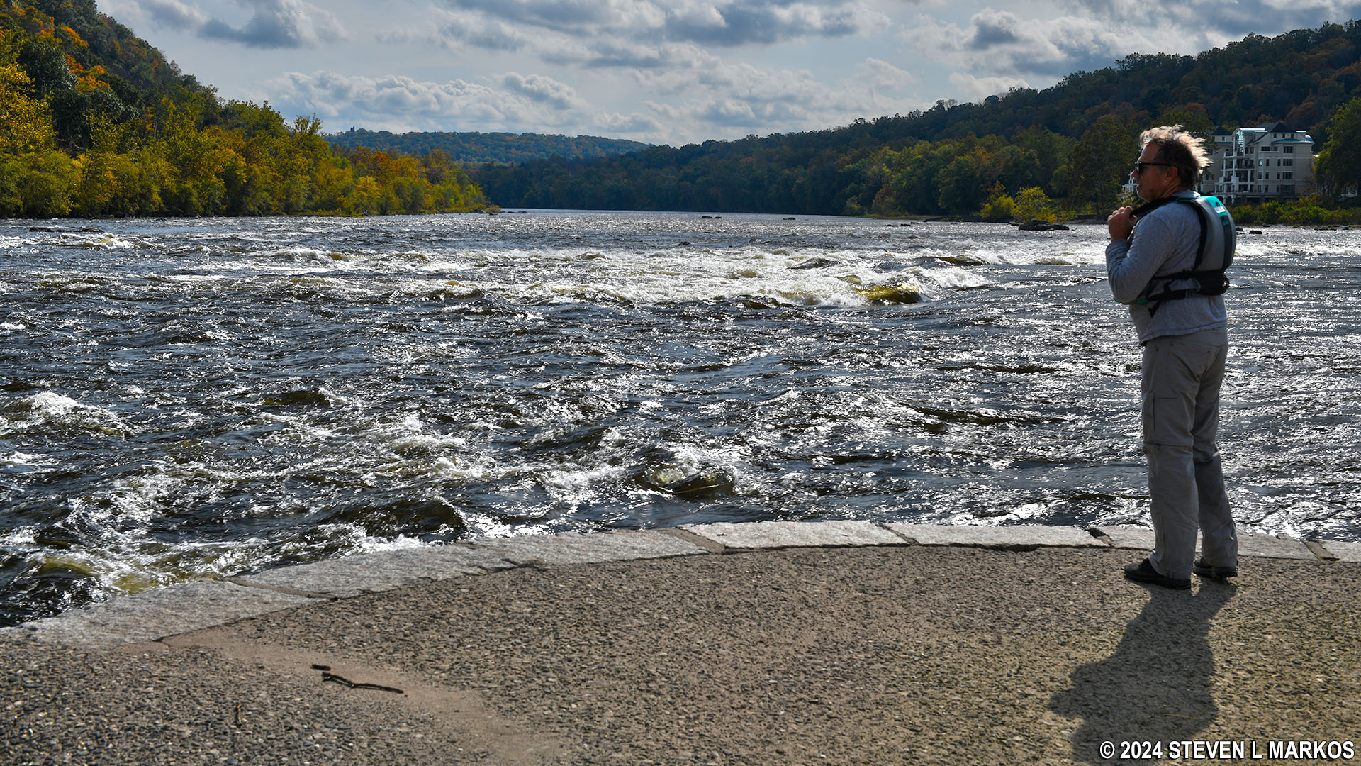
Checking out the rapids on the Lower Delaware National Wild and Scenic River at the Lambertville Wing Dam
Next River Section | Previous River Section | Paddling Home Page
With a few exceptions, use of any photograph on the National Park Planner website requires a paid Royalty Free Editorial Use License or Commercial Use License. See the Photo Usage page for details.
Last updated on February 25, 2024


