

Rapids on the Delaware River near Portland, Pennsylvania
KITTATINNY POINT TO PORTLAND WATERFRONT PARK RIVER TRIP
Length: 4 miles
Water Level at Time of Trip: 7.15 feet
Average moving speed: 4.3 MPH with two paddlers
Top Speed: 7.5 MPH
Time: 1 hour
If you want to pass through the gap in the mountain that gives Delaware Water Gap National Recreation Area its name, you must paddle past Kittatinny Point, the last boat launch within the park. The next public ramp is at the Portland Waterfront Park in Portland, Pennsylvania. From there you can continue downriver to the Lower Delaware National Wild and Scenic River, which starts a few river miles south of Belvedere, New Jersey, and runs to Washington Crossing State Park near Trenton.
Before starting a trip on the Delaware River, it is a good idea to check the water levels so you are aware of the river conditions. The National Park Service assesses conditions by using the USGS water level gauge at Montague (Milford Beach). Levels between five and seven feet are typical and provide plenty of water for a trip down the river with conditions suitable for anyone with basic paddling skills. If the Montague gauge reads less than four feet, there may be spots on the river with very little water. Levels over seven feet require more paddling experience, and the river is closed due to extreme danger when water levels at Montague reach fifteen feet. Be aware that regardless of water levels, extreme winds can cause turbulent conditions that require advanced skills on water otherwise suited for all paddlers.
The most pertinent water level gauge to Kittatinny Point is the Water Gap gauge just 3.5 miles upriver near Depue Island and the Worthington State Forest Campground. On the day of my trip, the Water Gap gauge reported 7.15 feet of water and the Montague gauge 7 feet. This was at least a foot higher than when I made my trip down the Delaware River from Milford Beach to Kittatinny Point a few days earlier. As a result, the rapids were much larger than anything I had previously encountered, though they were still nothing more than Class I and II rapids. While I don’t recommend this section at 7-foot-plus water levels for a solo paddler who has never been in a canoe or kayak, anyone with basic paddling skills should not have any problems. Regardless of skill level, if you haven’t been wearing your life jacket up to this point, I suggest putting it on.
Keep in mind that the observations in my report are based on the stated water levels. If you do the trip when the levels are lower, you may be dragging your boat to deeper water in some places and probably won’t experience the same degree of rapids as I report. If the water levels are significantly higher, you may experience more intense rapids, and more of them.
Upon launching from the Kittatinny Point Boat Ramp, which has a concrete ramp for motorboats and a cleared dirt area along the shore for canoes and kayaks, you will be staring at a huge tree-covered slab of quartzite in front of you and another mountain on the Pennsylvania side of the river. It looks like the river just dead ends up ahead. However, it actually makes a 90-degree right-hand turn and passes through a gap between the two mountains—the famed Delaware Water Gap. A water gap, as it turns out, is nothing more than where a river cut through a mountain, in this case the Delaware River and the Appalachian Mountains.

Mountains at the Delaware Water Gap just downriver from the Kittatinny Point Boat Ramp

The Delaware River passes through a gap in the mountains just downriver from the Kittatinny Point Boat Ramp in Delaware Water Gap National Recreation Area

Rock formation at the Delaware Water Gap
The water at the boat ramp is as still as a lake, but once you go around the bend and through the Gap, things pick up a bit. The Delaware River forks around Arrow Island a quarter mile from the Gap, and whenever a river splits into two smaller channels to go around an island, it typically picks up speed. I went around on the right side where there was a nice stretch of Class I rapids, and I was traveling at 6 MPH without doing much paddling.

Rapids on the Delaware River at Arrow Island in Delaware Water Gap National Recreation Area
The river calms down once past Arrow Island, though I was still traveling at more than 4 MPH. In fact, I rarely dipped below this speed all the way to Portland.

Calm water downriver from Arrow Island in Delaware Water Gap National Recreation Area
The southern boundary of Delaware Water Gap National Recreation Area is near Slateford, Pennsylvania, though there is no “YOU ARE LEAVING THE PARK” sign. This is two miles from Kittatinny Point and a little less than a mile from the downriver side of Arrow Island.
Three miles from Kittatinny Point is an interesting piece of history: the Delaware River Viaduct. The bridge was built between 1908 and 1910 as part of the Lackawanna Cut-Off rail line. It was last used by Amtrak in 1983.
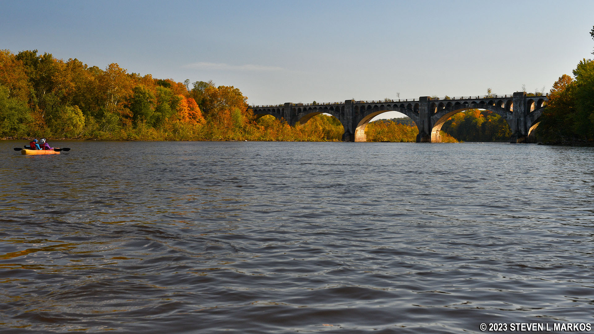
Delaware River Viaduct near Portland, Pennsylvania
Just before and after the viaduct is another nice run of rapids that were a little bigger than the ones at Arrow Island but still nothing to be concerned about. To put things into perspective, I was taking photos with a $3,000 camera while my buddy did the paddling, and I wasn’t worried about any mishaps. Expect to perhaps get splashed a little, but nothing more.

Rapids at the Delaware River Viaduct near Portland, Pennsylvania
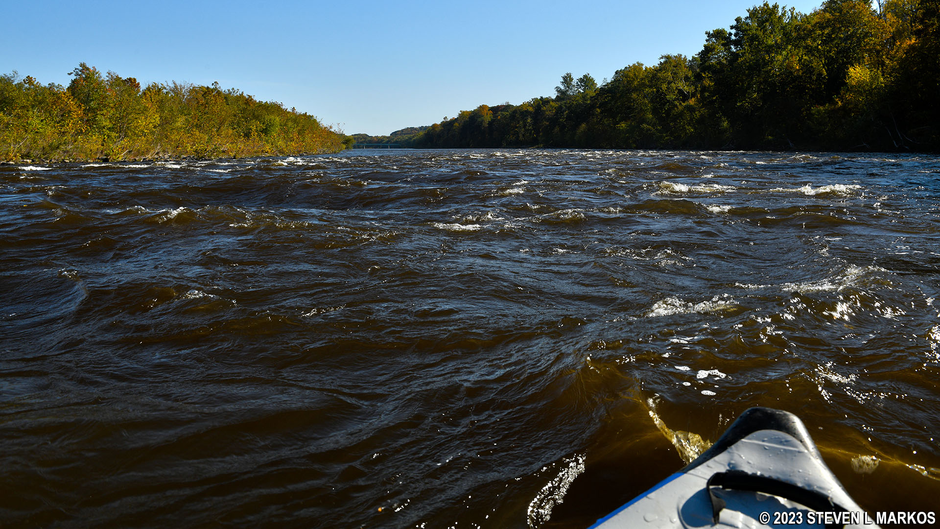
Rapids at the Delaware River Viaduct near Portland, Pennsylvania
A mile farther ahead is the Portland-Columbia Pedestrian Bridge followed by a highway bridge. From a distance, they appear as one, but the pedestrian bridge comes first.

Approaching the Portland-Columbia Pedestrian Bridge (front) and the Portland-Columbia Toll Bridge (rear) while paddling on the Delaware River
The take-out point is a canoe launch at the base of the pedestrian bridge on the Pennsylvania side (right) of the Delaware River. The water is calm in this area, so if you go past it, you can easily paddle back upriver. The hard part is carrying your boat up the steep, gravel path to the road above.

Canoe launch at the Portland-Columbia Pedestrian Bridge in Portland, Pennsylvania

Canoe launch at the Portland-Columbia Pedestrian Bridge in Portland, Pennsylvania
The canoe launch is located in a commercial area of Portland. If you are dropping off a vehicle, park in one of the store parking spaces. When ready to load your boat and gear, you can pull up along the side of the road in front of the ramp.
The Kittatinny Point—Portland river trip concluded my adventures on the Delaware River within Delaware Water Gap National Recreation Area.
Previous River Section | Paddling Home Page
With a few exceptions, use of any photograph on the National Park Planner website requires a paid Royalty Free Editorial Use License or Commercial Use License. See the Photo Usage page for details.
Last updated on February 9, 2024


