

Delaware River near the Bushkill Boat Ramp in Delaware Water Gap National Recreation Area
BUSHKILL ACCESS TO POXONO RIVER TRIP
Length: 8.25 miles
Water Level at Time of Trip: 5.65 feet
Average moving speed: 3.6 MPH with two paddlers
Top Speed: 4.9 MPH
Time: 2 hours and 15 minutes
With its concrete boat ramp and separate canoe launch, the Bushkill Access Boat Ramp is a convenient place to launch a trip down the Delaware River from within Delaware Water Gap National Recreation Area. Keep in mind that there is a fee to park here from mid-April through the end of October. There is no specific fee to use the boat ramp, so you can get dropped off or picked up for free as long as the vehicle transporting you does not park at the facility. If you do have to park and are using a hand-launched watercraft, there is no fee to use the Eshback Access Boat Ramp four miles upriver.

Canoe launch at Bushkill Access in Delaware Water Gap National Recreation Area
Before starting a river trip through Delaware Water Gap National Recreation Area, it is a good idea to check the water levels so you are aware of the river conditions. At the northern end of the park, the USGS water level gauge at Montague (which is at Milford Beach) is the gauge used by the National Park Service to assess conditions. Levels between five and seven feet are typical and provide plenty of water for a trip down the river with conditions suitable for anyone with basic paddling skills. If the Montague gauge reads less than four feet, there may be spots on the river with very little water. Levels over seven feet require more paddling experience, and the river is closed due to extreme danger when water levels at Montague reach fifteen feet. Be aware that regardless of water levels, extreme winds can cause turbulent conditions that require advanced skills on water otherwise suited for all paddlers.
On the day of my trip, the gauge at Montague reported 5.65 feet of water, and the only other gauge within Delaware Water Gap National Recreation Area, the Water Gap gauge at the southern end of the park near Depue Island and the Worthington State Forest Campground, reported 6.12 feet. Regardless of which gauge is more pertinent to the Bushkill-Poxono section of the river, there was plenty of water. Keep in mind that the observations in my report are based on these water levels. If you do the trip when the levels are lower, you may be dragging your boat to deeper water in some places and probably won’t experience the same degree of rapids as I report (historically, water levels at Montague rarely dip below five feet). If the water levels are significantly higher, you may experience more intense rapids, and more of them.
The Bushkill-Poxono river trip has more sections of white water than any section of the Delaware River within the park up to this point. But don’t expect a Deliverance-style adventure—whitewater or otherwise—at least not at six-foot water levels, because Class I rapids is as exciting as it gets. This is family-friendly paddling, and there is nothing on this section that beginners can’t handle. I would not hesitate to take along a small child who could swim, if I had one. There is a short run of choppy water just downriver from the Bushkill Access Boat Ramp, so you will immediately know what to expect. (Remember, children under the age of 13 must wear a life jacket at all times while on the river.)

Small rapids just south of the Bushkill Access Boat Ramp, Delaware Water Gap National Recreation Area
A mile downriver from Bushkill, the Delaware River forms a large S-curve that spans four river miles. At the apex of each curve, the water barely moves, so you really have to paddle. However, once coming out of the second curve, there are a number of small rapids that spice up the journey, with the first coming where the river forks to go around a small island roughly 3.5 miles from Bushkill. I went around it on the left side because there appeared to be some decent rapids, whereas the water looked calmer on the channel to the right. While nothing beyond Class I, I did get splashed a little, the first time this happened since starting my trip on the Delaware River the day before at Port Jarvis. It’s still tame, and even those with small children shouldn’t have any worries.

Small rapids on the Delaware River between Bushkill and Poxono at Delaware Water Gap National Recreation Area
Five miles from Bushkill is Depew Island (not to be confused with the aforementioned Depue Island farther downriver). I went around it on the right channel, though I don’t think it matters which way you go. I chose the right channel simply because the water seemed to be moving faster that way.

Rapids at Depew Island in Delaware Water Gap National Recreation Area
A mile after passing the downstream end of Depew Island is Poxono Island. I never even saw a channel going around it to the left, so either it is very narrow or filled in with dirt (which is what satellite images suggest). Thus, the only way around it is through the right channel.
The Poxono Boat Ramp is just past the downriver end of Poxono Island on the New Jersey (left) side of the Delaware River. The problem is that once you get around Poxono, there are some small islands with nothing but tall grass on them blocking the direct route to the ramp (I could see the boat ramp and parking area). If you stay along the right shoreline (Pennsylvania), keeping these islands to your left, by the time you pass them you will also have passed the boat ramp and must paddle back upriver to get to it—not a big deal due to slow current in this area.
You could also stick to the shoreline of Poxono Island and navigate the narrow channels between it and the smaller islands, which is what I did. The channels are shallow, but with the river gauges reading six feet on the day of my trip, there was enough water for paddling, but not by much. If you take this route, realize that while it looks like the channels may just dead end, there is an opening to the boat ramp. With what I know now, I suggest taking the first option, passing the islands and then paddling upriver to the ramp.
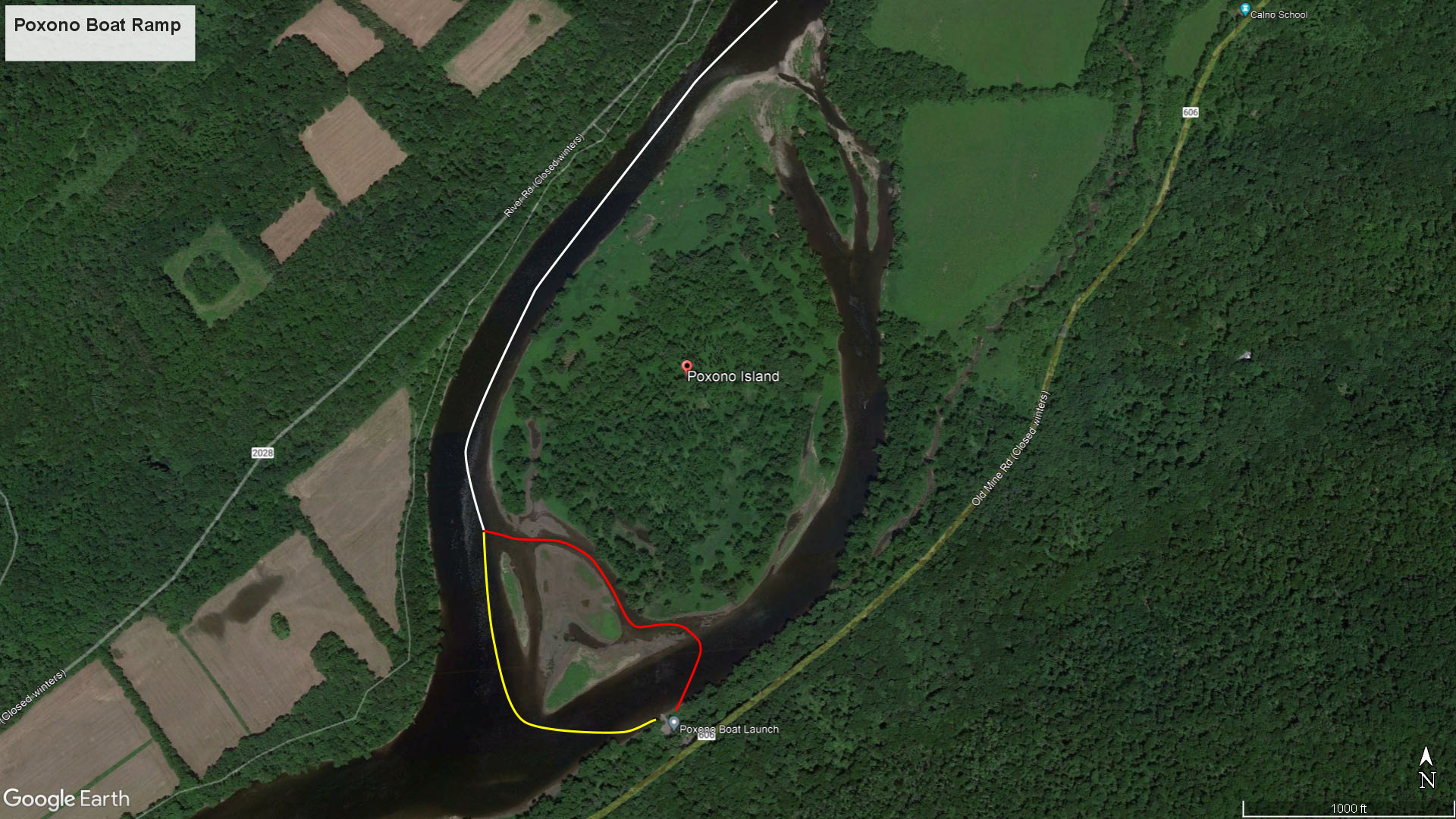
Route options to Poxono Boat Ramp
Channels between the small islands south of Poxono Island near the Poxono Boat Ramp, Delaware Water Gap National Recreation Area

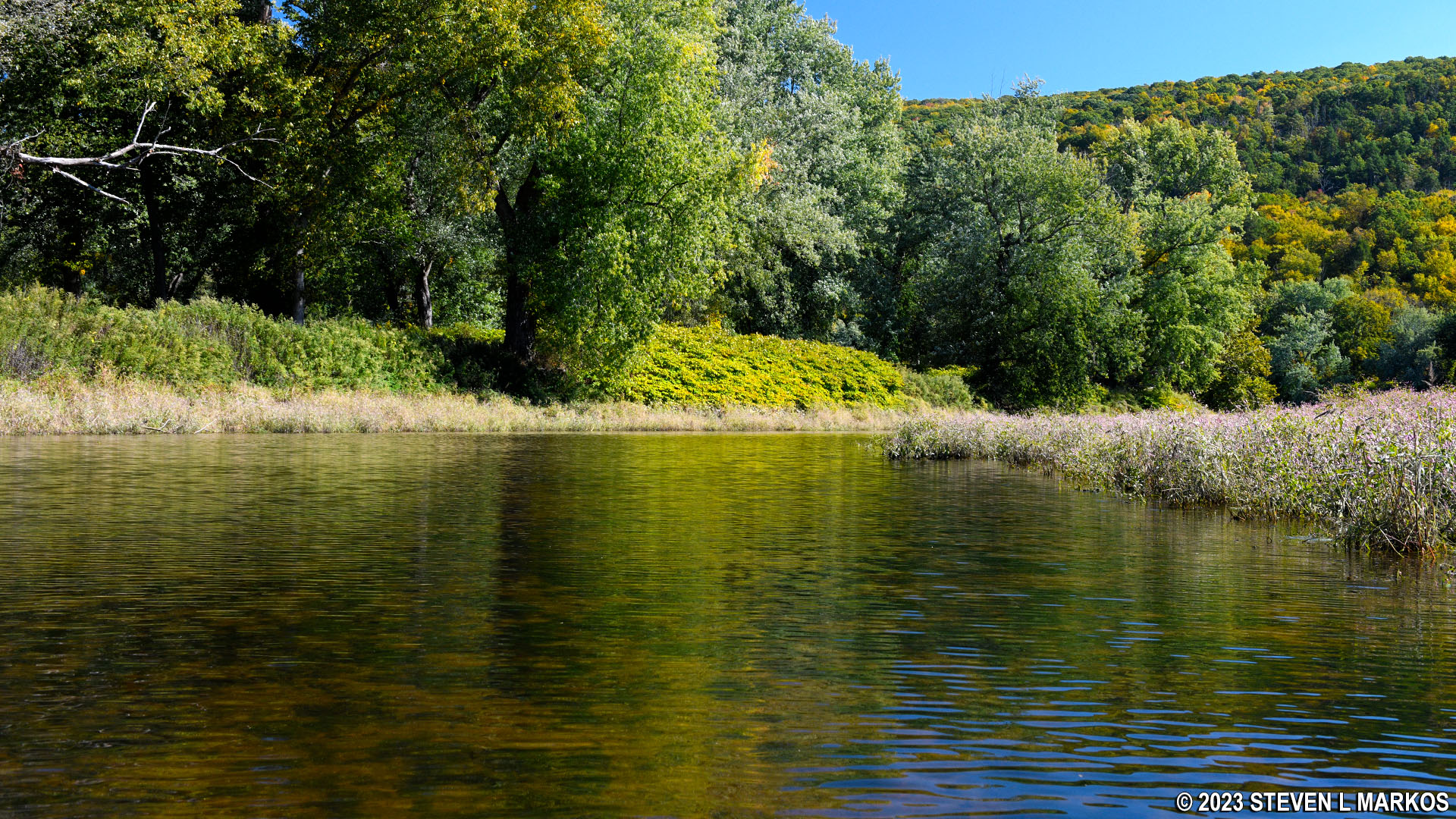
View of the Poxono Boat Ramp from the Delaware River, Delaware Water Gap National Recreation Area
Next River Section | Previous River Section | Paddling Home Page
With a few exceptions, use of any photograph on the National Park Planner website requires a paid Royalty Free Editorial Use License or Commercial Use License. See the Photo Usage page for details.
Last updated on January 29, 2024


