

Park Loop Hike Map (click to enlarge)
Length: 3.5-mile loop
Time: 3 hours
Difficulty: mainly easy, but with a few moderate and strenuous hills to climb
An excellent hike around Fort Washington Park that passes many historical sites, most of which are only accessible on foot, can be formed using traditional hiking trails and park roads. The loop is 3.5 miles long and takes about 3 hours to complete, including time to explore the sites. Most of the hike is on easy terrain, but there are some moderate to strenuous climbs along the way. I recommend wearing long pants due to the possibility of picking up ticks at some of the grassy spots on the trail.
While you can start the hike at various points throughout the park, I started near Light 80, the small lighthouse situated below Fort Washington. There is a parking lot not far from it, or, if you are at the fort, you can walk down the hill from the fort entrance to the river along a paved path. Once at the lighthouse, if facing the Potomac, turn to your left to find the trailhead for what is known as the River Trail. Initially a dirt road, the trail rounds the corner of Fort Washington and heads south along the river. However, due to trees, it is rare that you get a good view of the water.

Start of the River Trail near the lighthouse at Fort Washington Park in Maryland

Southwest corner of Fort Washington viewed from the River Trail at Fort Washington Park
The dirt-road segment lasts a little less than a half mile, and after crossing a boardwalk that spans a wet area, the trail becomes a traditional, earthen hiking trail. From this point until you reach Battery Wilkin in approximately .75 mile, the River Trail is poorly marked. The bad news is that you are very likely to get confused as to which way to go. The good news is that the general route of the hike follows the Potomac River, so as long as you keep the river on your right, either within sight distance or at least close enough to be aware of its presence, you will find your way to the battery. What has happened is that the trail ascends to a bluff high above the river, and the National Park Service tries to keep people away from the potentially dangerous cliffs. Over the years hikers have blazed their own “social trails” to the cliffs, and it eventually became impossible to tell the difference between the official River Trail and the social trails. But as I said, as long as you keep the river on your right, you’ll end up on the River Trail and heading towards Battery Wilkin.
Numbered posts topped with yellow paint appear along the trail. Most likely there was a brochure with written descriptions of the nature or history surrounding each post, but to my knowledge no such brochure exists today. The posts do, however, make good geographical reference markers. For example, just past Post #3, about a quarter mile from the boardwalk, is the ruins of an unknown structure. I can’t say what it is, other than it is not an artillery battery.

Unknown structure near Post #3 on the River Trail at Fort Washington Park in Maryland

Unknown structure near Post #3 on the River Trail at Fort Washington Park in Maryland
The trail dead ends just past Post #4, and you must take a left or right—no sign indicates which way to go. Using my “stick to the river” theory, I went right, though I later realized that no matter which way you turn you will get to the same place. The trail follows a hilly bluff high above the Potomac, and the ups and downs are tackled with the help of stairs while railings keep those less coordinated from falling off the cliff. Because the National Park Service went to the trouble of installing such equipment, I assume this is the official River Trail and that taking a right was the correct decision.

River Trail along the bluff above the Potomac River, Fort Washington Park
There is another intersection at Post #5, again with no directional signage. The path straight ahead was blocked off with logs; a right leads to the Potomac; a left cuts inland. The correct way to go is straight, but since that was blocked I again opted to head towards the river. It turns out that proceeding straight or turning right gets you to the same place. Straight is just a more direct route, but less scenic, and I therefore suggest taking a right.

Intersection at Post #5 on the River Trail at Fort Washington Park in Maryland
No sooner do you turn than the trail splits again, though this time it’s easy to figure out which way to go. A right just heads to a cliff where you can get a great view of the Potomac River. Check it out and then continue down the trail to the left.

Fork on the River Trail at the bluff overlook, Fort Washington Park

View of the Potomac River from the River Trail in Fort Washington Park
At this point the trail is extremely steep—tippy toe steep. That’s where you find yourself pushing off on your tiptoes to move forward, and your heels never touch the ground. The trail runs right along the cliff, so there are some nice views at various points along the way. Eventually the trail comes out to the right of a set of stairs, which is where you would have been had you stayed straight back at Post #5. Continue the uphill climb using the stairs. At the top is a bench where you can take a break.

Stairs on the River Trail to the top of the hill beyond Post 5, Fort Washington Park

Bench along the River Trail at the top of a hill overlooking the Potomac River, Fort Washington Park
At 1.4 miles into the hike the trail cuts inland, away from the river, and works its way along Fort Washington Park’s eastern border. You are now out of the hills and back on level terrain. Grass has grown up on the trail, so be sure to check for ticks. While it is not overgrown, the path does become a little faint.

Inland route on the River Trail to Battery Wilkin in Fort Washington Park
In less than five minutes you will come to a hill with a path leading to the top, only this is no ordinary or natural hill. You are on the river side of Battery Wilkin, viewing it from the direction that enemy ships on the Potomac would see it (when in service, the forest was not here). From this direction the battery is covered with earth. This not only provides camouflage, but also extra protection from the impact of artillery shells fired from the water. Walk around the hill to get to the front side of the battery.

River side of Battery Wilkin in Fort Washington Park
Battery Wilkin is off the beaten path as far as batteries at Fort Washington Park go, and because of this the National Park Service hasn’t fenced it off despite the fact that the place is falling apart (besides, people would just tear down the fence to get to it anyway). Because it has not been sanitized for your protection, it is definitely one of the coolest of all batteries in the park. Broken railings and missing stairs make exploring the structure a challenge, and considering that parts of it could collapse at any time, a little dangerous. But what the hell…that’s what adventure is all about. See the Battery Wilkin web page here on National Park Planner for additional information and photos.

Battery Wilkin in Fort Washington Park
From Battery Wilkin to the next point of interest, Battery Meigs, the trail is an old, crumbling asphalt road. It is .4 mile between the two structures, and the route is easy to follow, not convoluted like the earthen trail along the river. Despite now being on a former road, this is still the River Trail, which officially ends at Battery Meigs.

Typical terrain on the River Trail between Battery Wilkin and Battery Meigs, Fort Washington Park
Battery Meigs is in much better shape, but it is closed to the public and is now used as a storage facility for the National Park Service. This was a mortar battery, so all guns were at ground level in a pit concealed by a high wall. See the Battery Meigs web page for additional information and photos.

Battery Meigs at Fort Washington Park
Once done exploring the battery, continue down the park road. In the distance you will see two old buildings, the only post-1900 buildings left at Fort Washington Park. The larger of the two is the former Post Exchange and gymnasium and the smaller is a non-commissioned officers’ barracks. See the Military Buildings web page for additional information and photos.

Post Exchange building at Fort Washington Park
When you come to the main park road, take a right and head towards the entrance gate. To pick up the next segment of the hike—a trail known as the Pump Station Trail (though no sign identifies it)—walk past the old pay station building as if leaving the park and be on the lookout for the trailhead on your left. This trail will take you to the northern tip of the park before curving westward back towards the Potomac River.

Pay station at the entrance to Fort Washington Park

Pump Station Trail near the entrance to Fort Washington Park in Maryland
While now dirt, the trail is wide and appears to be another former road. It is marked by numbered posts with their tops painted blue. Remnants of asphalt can be seen at the start, but the trail quickly becomes a gravel path, remaining that way until coming to the border fence at the northern end of the park. When you reach the fence you will have come 2.6 miles, with approximately 1 mile left on the hike.

Typical terrain at the start of the Pump Station Trail in Fort Washington Park
From the fence, the trail curves westward, transitions into a traditional hiking trail, and becomes very hard to follow at times. You will find yourself in an open canopy forest with very little clutter on the ground, which gives grass ample opportunity to grow, often to the point where it hides the trail. There were numerous times when I had to hunt around to find where the trail continued.

Faint traces of trail on the second half of the Pump Station Trail in Fort Washington Park
At the 2.8-mile mark the trail intersects with another old park road, identified as a road only by its width and occasional tire tracks that have been worn into the ground. The Pump Station Trail continues to the right; a left takes you inland and towards the main park road. The path is mainly grass with a core of gravel. Be aware of ticks whenever you walk through such terrain.

Intersection of the Pump Station Trail and a former park road at the northern end of Fort Washington Park in Maryland
Just up ahead is some sort of machine and an old building that is fenced off and nearly consumed by vegetation. My guess is that this is the pump station that gives the Pump Station Trail its name. A pump station is a facility with equipment to pump fluid from one place to another. An engine and drive shaft connect to some sort of contraption that I cannot identify, and a pipe runs into the ground. The engine has a brand plate on it, Twin Disc Clutches, which is a company that is still around, having been making twin disc transmissions since 1918. The piece of equipment that I cannot identify has the name Pomona on it.

Old machines along the Pump Station Trail in Fort Washington Park

Old machines along the Pump Station Trail in Fort Washington Park
Just past the “pump station” is Swan Creek, which flows into the Potomac River a short distance ahead.

Swan Creek viewed from the Pump Station Trail at Fort Washington Park in Maryland
The trail eventually forks, though the split is not very obvious (I walked right past it). You want to leave the old road and take the Swan Creek Trail (aka Waterside Trail), which like the Pump Station Trail is not identified. Be on the lookout for a very narrow trail on your right that is marked with a blue post with a 0.5 on it, a mileage indicator back to the lighthouse.
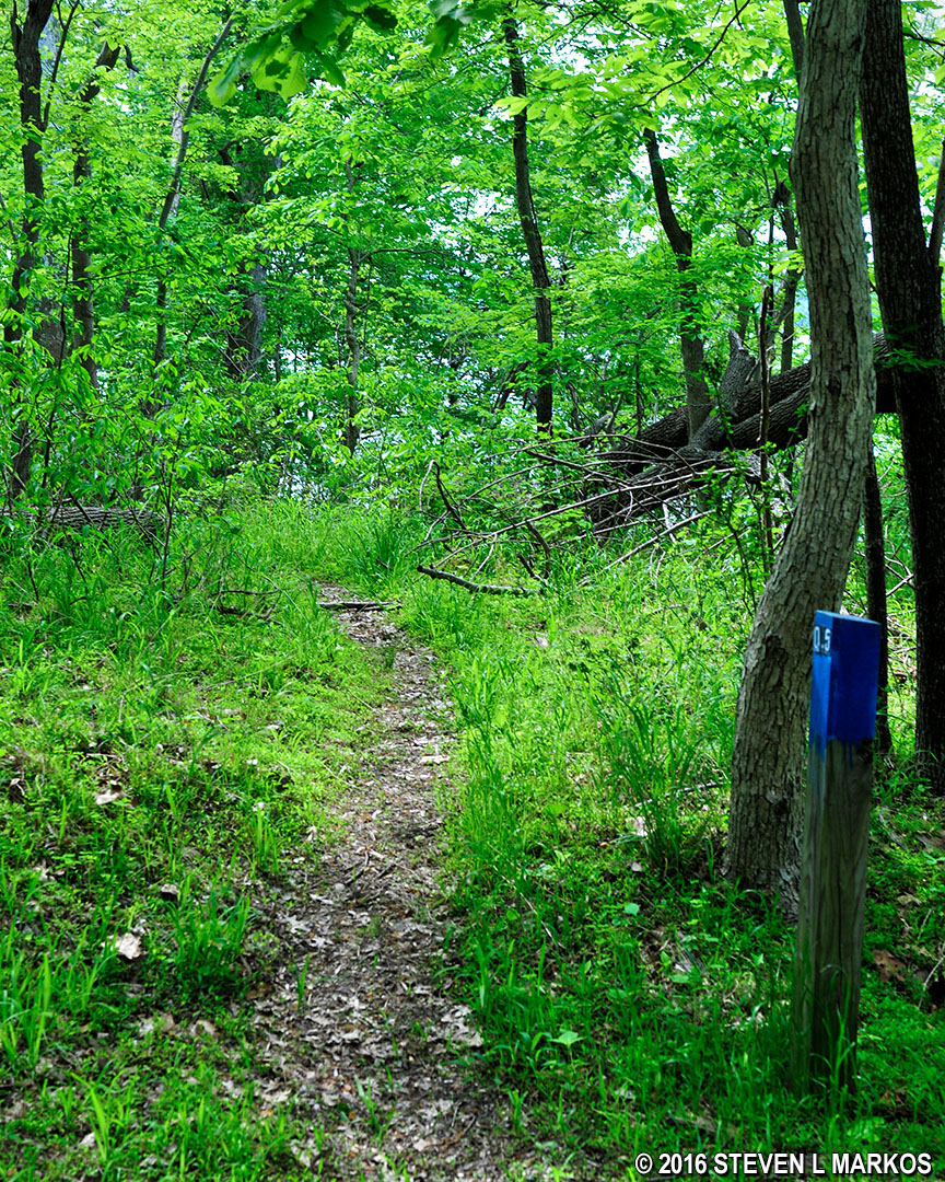
Start of the Swan Creek Trail at Fort Washington Park in Maryland
The Swan Creek Trail is easy to follow, so you should not get lost or confused. Aside from running along Swan Creek, the only other point of interest is the old Torpedo Storage building located towards the very end of the hike—it is not open to the public. This was built in the 1890s when the artillery batteries were being installed at the fort. Fort Washington was not a submarine base, so why a torpedo storage building? This is actually a building for storing mines that were placed in the Potomac and detonated electronically from the fort. The word torpedo originally referred to an explosive, water-based mine, not a vehicle-launched, self-propelled explosive device as it does today.

Torpedo storage building at Fort Washington Park
Just past the torpedo building is the end of the trail. Before reaching it you will find yourself walking below the parking area. If you parked here, there is no reason to walk to the lighthouse and back, so just make your way up the hill. There are numerous social trails to the top.
If you have the time and are game for a 3.5-mile hike, I highly recommend this loop around the park. When I am at a historical site, I have no interest in hiking trails for scenic beauty. I want them to add to the overall historical atmosphere of the park. Seeing the lighthouse, walking below Fort Washington, and passing two batteries, a torpedo storage building, and a “pump station,” the Park Loop Hike certainly has its share of history and definitely meets my criteria for an interesting hike.
With a few exceptions, use of any photograph on the National Park Planner website requires a paid Royalty Free Editorial Use License or Commercial Use License. See the Photo Usage page for details.
Last updated on November 21, 2024


