

Unfinished Railroad Loop Trail map (click to enlarge)
Note: The trails at Manassas National Battlefield Park are poorly marked, so be sure to bring a trail map with you for navigational purposes. The best is the Trail Guide, a tri-fold map that is free at the Henry Hill Visitor Center. For planning purposes, you can download it here, but be sure to pick up a full-color version before you begin your hike.
Manassas Trail Map (PDF)
Length: 1.25-mile loop
Time: 45 minutes
Difficulty: Easy
If you’ve read anything about the Second Battle of Manassas, then you probably know that Confederate General Stonewall Jackson positioned his men behind an “unfinished railroad” and used it as an effective defensive position for the duration of the battle. But what exactly is an unfinished railroad? To keep the tracks out of the water in case of flooding, the railroad was built on an elevated platform created by digging ditches on either side of the route and piling the dirt in the middle. This artificial hill provided the Confederate army with an excellent place to hide behind. Soldiers could spend days digging a trench and building a similar wall—here was one already completed. It would not only slow down attacking Union soldiers, but they would have to scale the hill before charging down the other side, which left them exposed to musket and cannon fire. Furthermore, it would be next to impossible for them to bring artillery or other heavy equipment with them. If you hike the Unfinished Railroad Loop Trail, you can actually see this rail bed, which remained unfinished—no tracks—because the Manassas Gap Railroad ran out of money to complete the project, an Alexandria to Gainesville rail line.
The trailhead for Unfinished Railroad Loop Trail is located to the left of a wayside exhibit in the parking lot for Stop #6 on the Second Manassas Battlefield Tour. After a minute’s walk the trail splits and the loop starts. You may not even notice the split, but just keep walking straight to hike the loop in the clockwise direction.

Trailhead for the Unfinished Railroad Loop Trail at Manassas National Battlefield Park
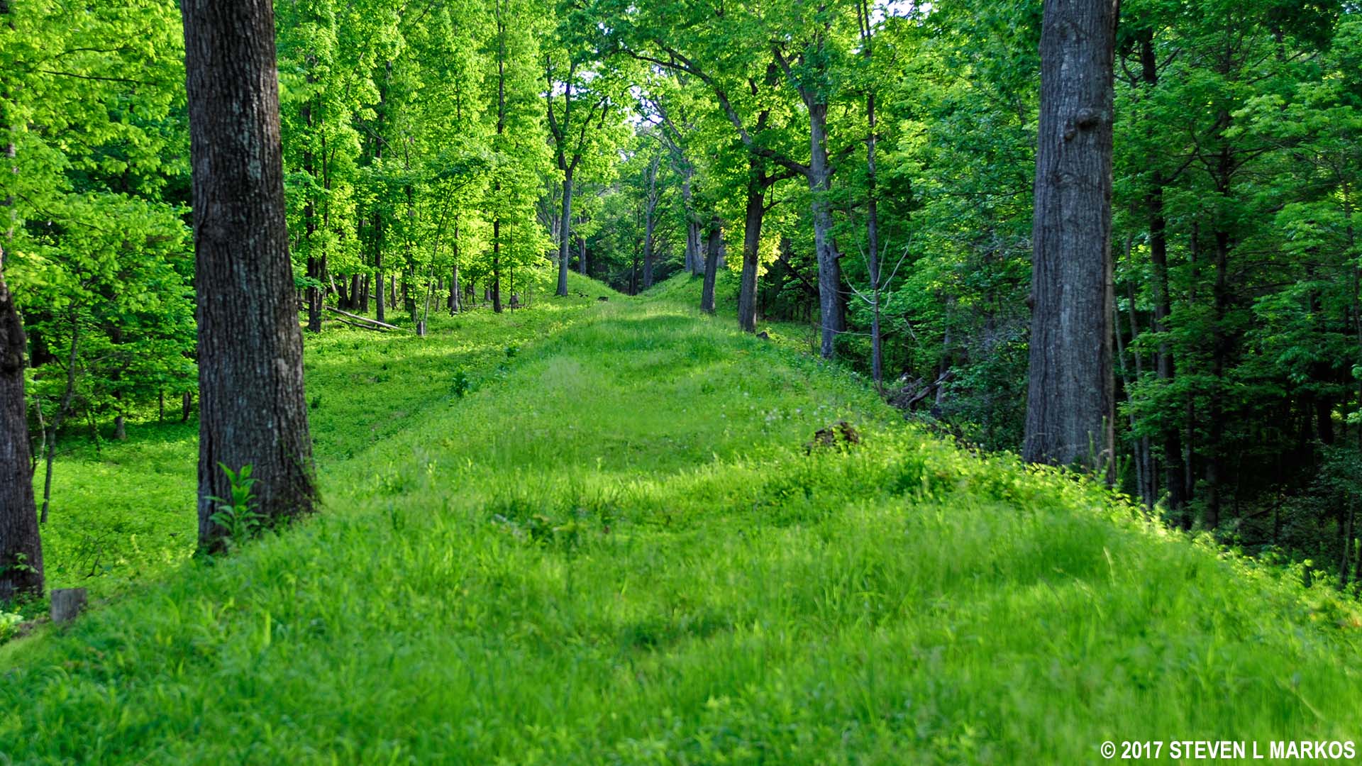
The Unfinished Railroad Loop Trail has to be the narrowest loop trail in existence. Just imagine walking down one side of a railroad track, crossing the track, and then walking back on the other side and you basically understand the layout. Of course, this description is a little simplified, for as you walk the trail you find yourself alternating between hiking in a gully with low embankments on either side, hiking a trail with a tall hill on one side, and hiking along the top of the elevated railroad bed. I could never understand why the elevated bed vanished at times—as if it had been plowed away—or why I was in a shallow gully one minute and walking along a tall embankment the next, but regardless, you do get an understanding of what the Unfinished Railroad was all about.

Gully at the side of the elevated railroad bed of the unfinished railroad, Manassas National Battlefield Park

Section of the Unfinished Railroad Loop Trail along the side of the elevated railroad bed, Manassas National Battlefield Park
Section of the Unfinished Railroad Loop Trail that follows along the top of elevated railroad bed, Manassas National Battlefield Park
On the way out the Unfinished Railroad Loop Trail is on the Confederate side of the railroad bed. This is evident by the signs posted along the trail that contain eyewitness accounts of the battle from Confederate soldiers. Confederate exhibits are found along Confederate lines and Union exhibits along Union lines. Such exhibits are a common feature on the trails at Manassas National Battlefield Park, and they are quite interesting, so take the time to read them.

Exhibit along the Unfinished Railroad Loop Trail gives an eyewitness account of the Second Battle of Manassas from a Confederate soldier’s view point, Manassas National Battlefield Park
I always pictured the Confederates pressed up against the slope of the rail bed waiting for Union soldiers to come up and over the top. Yes, there was a line of soldiers close to the slope, but there were two other defensive lines staggered back from the railroad, with the last being as far as 250 yards away. Thus, Union soldiers would have to charge up and over the hill, fight the first line, and then fight through two more lines of defense in order to break through and force a fight from the front and the rear, which usually results in the enemy surrendering. However, once you punch a hole in the defensive line you must keep the gap flooded with your own men, otherwise the hole can close up behind you and you’ll find yourself surrounded. It’s like busting into a room full of your enemies and having the door shut behind you. If you can’t keep that door open with a flood of your own friends, you’re going to end up dead. This is the situation Union General Cuvier Grover and his men found themselves in on August 29, 1862, the second day of the battle. They were able to break through two of the three Confederate lines, but there were no troops to support them, and they eventually had to retreat. Grover lost 487 men (dead, wounded, or prisoner), a third of his unit.
The elevated rail bed could also work as a great offensive position, and it was used as such by both armies. One of the Union exhibits tells a story of the Confederates suddenly appearing at the top of the rail bed and firing into the advancing Union soldiers. On a hill you certainly have a good view of the enemy, and once you have fired you can slide back down and reload under the protection of the hill.
You can actually follow the Unfinished Railroad all the way to Sudley Church, but as far as the loop trail is concerned, the end comes .6 mile into the hike. Follow the directional signs and you will switch over to the east side of the railroad—the Union side. At this point the trail veers a little from the railroad and into the forest, though this stint lasts only a tenth of a mile. After that, it’s back to the railroad bed for the remainder of the hike, only fifty yards or so from where you were on the way out.

A short segment of the Unfinished Railroad Loop Trail on the Union side of the unfinished railroad bed veers into the forest, Manassas National Battlefield Park
When I am hiking in a historical park, I don’t care much about scenery, but I do like the trails to enhance the historical experience. The Unfinished Railroad Loop Trail is probably the most important in the park, because up until I hiked it, I did not have a clear idea as to what exactly was an unfinished railroad. The hike is easy, with a hill here and there, and can be completed in less than an hour.
There is a second trailhead at the parking area, but this is for one of the horse trails. It is marked by a plastic post with a yellow circle on it. The Second Manassas Trail also comes through here, merging with the horse trail for a short distance before breaking off on its own and heading towards Deep Cut.

Bridle Trail and Second Manassas Trail at the Unfinished Railroad parking lot in Manassas National Battlefield Park
With a few exceptions, use of any photograph on the National Park Planner website requires a paid Royalty Free Editorial Use License or Commercial Use License. See the Photo Usage page for details.
Last updated on June 18, 2025


