
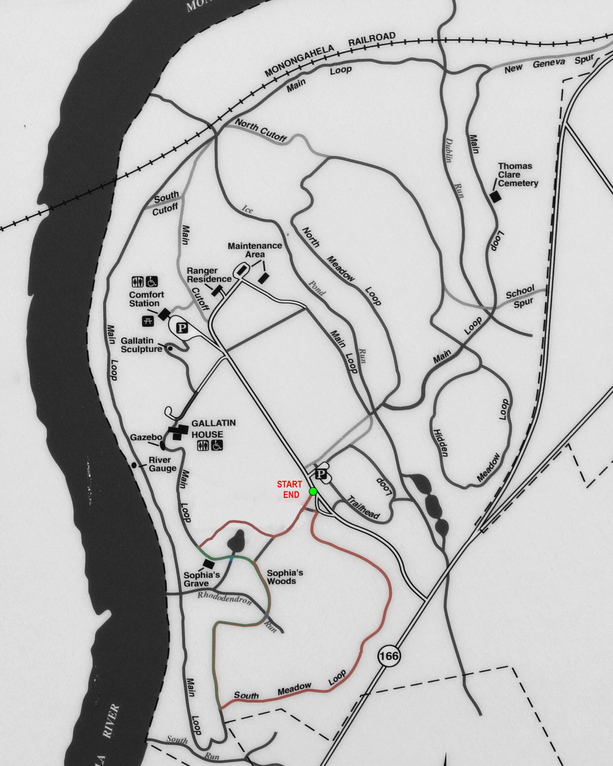
South Meadow Loop Trail Map (click to enlarge)
Length: 1.2-mile loop; add .3 mile for side trip to Sophia’s Grave
Time: 45 minutes
Difficulty: Easy with a few small hills
Before starting out on a hike around Friendship Hill National Historic Site, be sure to pick up a trail map at the Visitor Center. While the map is printed in black and white and lists trails by name, keep in mind that directional signage at the actual trailheads and intersections goes by colors, not names. Green is for the Main Loop Trail. Red is for the various meadow trails. Yellow tends to be for short connectors between the red and green trails.

Directional signage on the trails at Friendship Hill National Historic Site
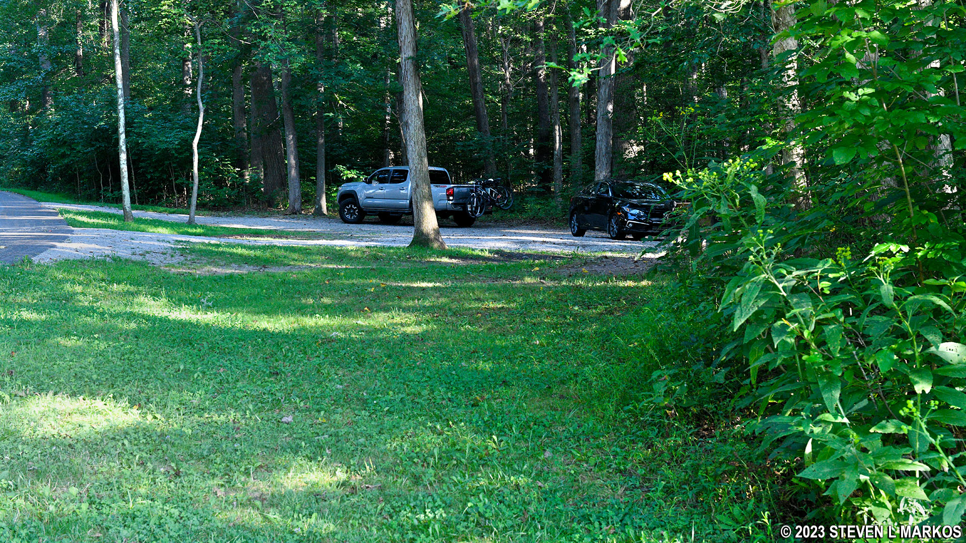
The South Meadow Loop Trail is located at the first parking lot on the left after exiting Highway 166 onto the Park Entrance Road. This is basically a pull-through driveway alongside the road. The trail itself starts at one end of the driveway and comes out on the other end.
As with most trails at Friendship Hill National Historic Site that have MEADOW in their name, rarely will you see anything resembling a meadow on this hike. Ironically, there is a huge meadow to the north, and about a tenth of a mile of the South Meadow Loop Trail runs along it, but the rest of the 1.2-mile hike is in the forest. What typically happens with a meadow is that it eventually gets filled in by trees. Thus, there may well have been a meadow many decades ago when the park opened in the early 1980s, but today the area is a forest.
I started the hike at the trailhead on the south end of the driveway, which set me off hiking around the loop in the clockwise direction. At this point the trail is nothing more than a dirt road through the forest, though most of it is now covered in grass. The terrain is easy to hike with some slight hills. I mention this only to make it clear that the trail is not completely flat.

Southbound trailhead of the South Meadow Loop Trail at the park entrance road, Friendship Hill National Historic Site

Typical terrain on the eastern segment of the South Meadow Trail at Friendship Hill National Historic Site
At .6 mile from the start, the South Meadow Loop Trail intersects with the Main Loop Trail. The segment north of the intersection—which is where you want to go—is shared by both trails. A left is the Main Loop Trail only, and this leads down to the Monongahela River via one of the steepest hills in any National Park on the east coast.
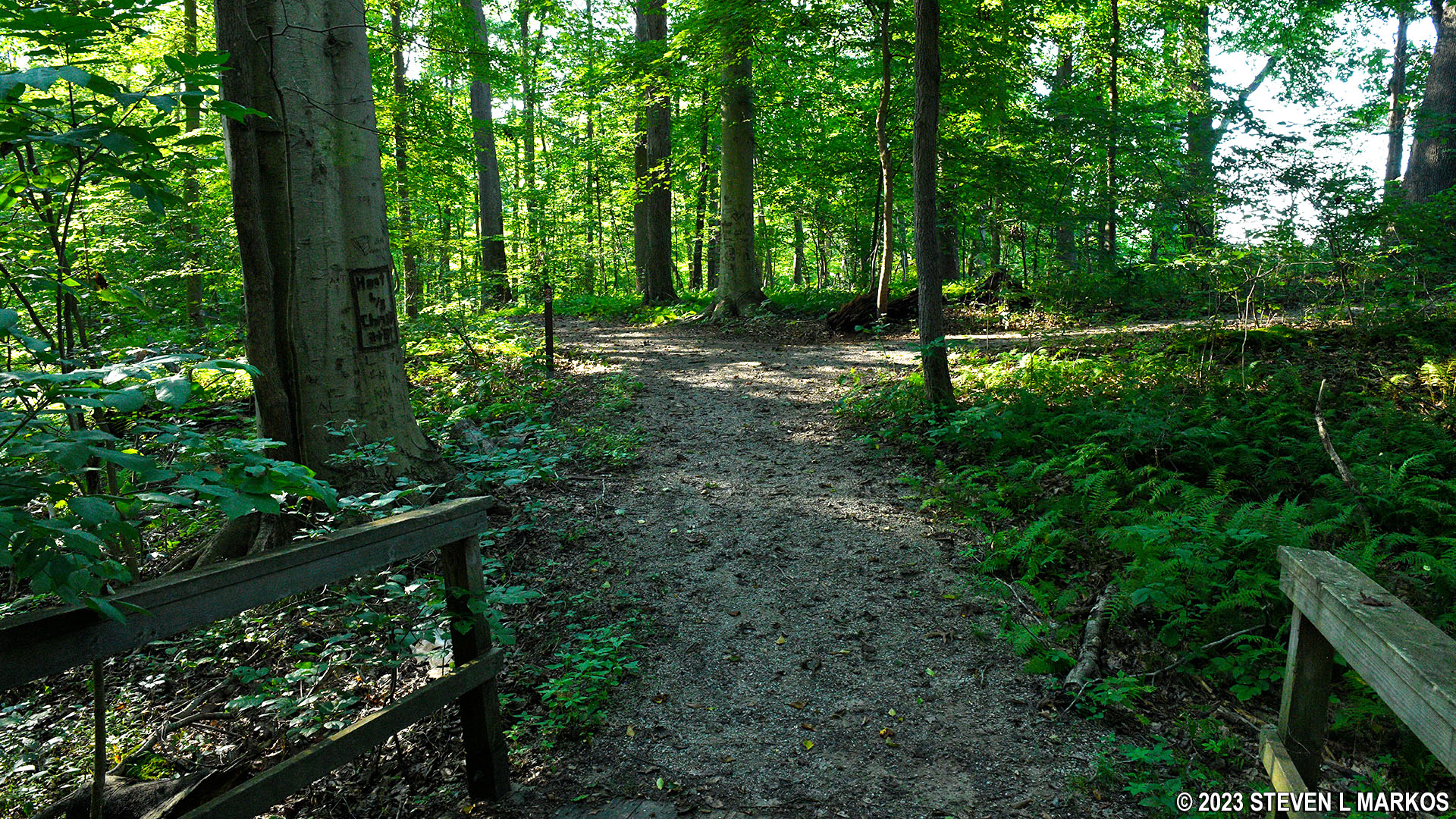
The Main Loop / South Meadow Loop in this area is a traditional hiking trail, one of the few such trails in Friendship Hill National Historic Site (most are old roads). It starts off as a very narrow footpath and is a little hard to follow, but it widens into an easily discernable trail very quickly. The terrain is hillier than before but still easy to hike.

Southern intersection of the South Meadow Loop and Main Loop trails, Friendship Hill National Historic Site

Typical terrain on the South Meadow / Main Loop trails at the southern end of Friendship Hill National Historic Site
The South Meadow Trail crosses three small streams via footbridges, and just after the third bridge it turns right, breaking away from the Main Loop Trail (1 mile into the hike). This sends you on a direct path back to the parking lot less than .2 mile away, thus ending the hike. However, if you haven’t visited the supposed grave site of Albert Gallatin’s first wife, Sophia Allegre, stay straight. You can hike to the grave and then come right back to this point to continue, or just keep hiking past the grave to another Red Trail intersection and make a loop back to the South Meadow Loop Trail. The loop adds .3 mile to the hike while the trip out-and-back to Sophia’s grave is less than .2 mile. I did the loop because I didn’t want to see the same things twice, but if I had to do it over, I’d just walk to the grave and back.
Intersection of the Main Loop and South Meadow Loop trails south of Sophia’s Grave at Friendship Hill National Historic Site
Before coming to the grave site, you’ll pass a small pond. I hiked the Main Loop Trail earlier and saw a few large snapping turtles. I get the feeling that people feed them because they came swimming my way as soon as they saw me.

Pond near Sophia’s Grave at Friendship Hill National Historic Site

Snapping turtle in a pond at Friendship Hill National Historic Site
Sophia’s grave is not far from the pond. In May 1789, Gallatin married Sophia Allegre, and that same year he began construction on a house at his Friendship Hill property. Sophia died that October, only five months after getting married, and is supposedly buried in an unmarked grave on the property. According to legend, subsequent owners of Friendship Hill removed her remains from the original grave and reinterred them within the current stone enclosure, though there has been no effort to excavate the site and verify the story. All that is known for sure is that she requested to be buried on a hill overlooking the Monongahela River. Nobody even knows how she died.

Supposed site of Sophia Allegre’s grave at Friendship Hill National Historic Site
The Red Trail intersection is just around the corner from the grave site. There is no sign post identifying it, but it is the mowed path on the right that follows the tree line along a meadow (the meadow to the north that I mentioned earlier). The trail works its way around the other side of the pond and eventually connects to the trail that leads back to the parking lot.

Red Trail north of Sophia’s Grave at Friendship Hill National Historic Site
The trail back to the parking lot is the aforementioned .1-mile segment that runs along the meadow. It ends at the road just a few yards from the northern entrance to the pull-through driveway.
View from the northern park road trailhead of the South Meadow Trail at Friendship Hill National Historic Site
As with most trails at Friendship Hill National Historic Site, the South Meadow Loop Trail is for exercise purposes only. The hike, including the loop around Sophia’s Grave, took me 45 minutes.
With a few exceptions, use of any photograph on the National Park Planner website requires a paid Royalty Free Editorial Use License or Commercial Use License. See the Photo Usage page for details.
Last updated on November 30, 2024


