

Trail to the top of Kennesaw Mountain, Kennesaw Mountain National Battlefield Park
Length: 5.4-mile loop
Time: 4 hours, including rests and seeing the exhibits
Difficulty: Moderate to Strenuous
A loop hike around the northern end of Kennesaw Mountain National Battlefield Park, from Kennesaw Mountain to Pigeon Hill, begins at the Visitor Center. Hikers can start by heading to the top of the mountain on the Kennesaw Mountain Trail and doing the loop in the counterclockwise direction, or on the Camp Brumby Trail and proceeding around in the clockwise direction. Both trailheads are located on the hill off to the right of the building—just follow the crowd. I began by hiking up the mountain, and this trail report is written from that perspective. (Note: a trail map is available for free inside the Visitor Center.)

Kennesaw Mountain Loop Hike Map (click to enlarge)
The hike up Kennesaw Mountain is a 1-mile, strenuous climb that takes 45 minutes to an hour to complete, including stopping to see the views and exhibits at the top. The trail alternates between a smooth, gravel path and one strewn with rocks and roots.

Rocky section on the Kennesaw Mountain Trail on the way to the mountain summit, Kennesaw Mountain National Battlefield Park
The Kennesaw Mountain Trail eventually comes to a parking lot at the end of Kennesaw Mountain Drive, the vehicle road to the top. Once there, climb the staircase to the adjacent observation platform for a view east towards Atlanta, which is located far off in the distance on the horizon. Keep in mind that the parking lot is not at the summit. To get there, take the paved path that continues from the observation platform. It is a five-minute walk to the top.

View from the observation platform adjacent to the parking area near the top Kennesaw Mountain, Kennesaw Mountain National Battlefield Park

Walking path from the parking lot to the top of Kennesaw Mountain, Kennesaw Mountain National Battlefield Park

Cannon at the summit of Kennesaw Mountain, Kennesaw Mountain National Battlefield Park
Once past the exhibits, continue on towards Little Kennesaw Mountain. The trail heads downhill through extremely rocky terrain. Keep your eyes at your feet and plan two to three steps ahead, for a misstep could result in a twisted or broken ankle. If you have hiking poles, they will come in very handy. If not, just be careful.

Rocky terrain on the section of trail between Kennesaw Mountain and Little Kennesaw Mountain, Kennesaw Mountain National Battlefield Park
From the summit of Kennesaw Mountain, it is a .2-mile hike to where the trail crosses Kennesaw Mountain Drive. There is a nice view of Little Kennesaw Mountain, a bench, and a wayside exhibit with information about how Confederate soldiers hauled cannon to the top. The trail changes names to Little Kennesaw Mountain Trail on the south side of the road.

View of Little Kennesaw Mountain from an observation point on Kennesaw Mountain Drive, Kennesaw Mountain National Battlefield Park
The hike up Little Kennesaw Mountain is much easier than the hike up Kennesaw Mountain, and the trail is a much smoother gravel path. The summit is a half mile from the road, and at the top is the site of the former Fort McBride. Cannon mark the location, but unfortunately, there are no wayside exhibits with information about the fort. Allow five minutes to see the site.

Cannons at the Fort McBride site atop Little Kennesaw Mountain, Kennesaw Mountain National Battlefield Park
Not far past Fort McBride is a fork in the trail—stay to the right. Soon afterwards you will be heading down Little Kennesaw Mountain towards Pigeon Hill, and the trail is as rocky and slow going as the hike down Kennesaw Mountain.

Rocky terrain on the trail between Little Kennesaw Mountain and Pigeon Hill at Kennesaw Mountain National Battlefield Park
In roughly three quarters of a mile, the trail—which changes names to the Pigeon Hill Trail—comes to the intersection with the Little Kennesaw Cutoff, a short connector over to the Camp Brumby Trail on the east side of the loop. Unless you want to cut the hike short, continue straight on the Pigeon Hill Trail.
The Pigeon Hill Trail remains smooth and free of rocks for about a hundred yards, and then suddenly there are so many rocks that it is hard to even find a discernable trail. My advice is to just keep hiking straight ahead. Even though I often felt lost, I would always catch a glimpse of a worn path, perhaps 20 feet to my right or left. While I may have gotten off the trail, it wasn’t long before the correct route magically appeared. If you see signage that marks Confederate troop positions during the fighting at Kennesaw Mountain, you are on the right path.

Rocky terrain at the top of Pigeon Hill, Kennesaw Mountain National Battlefield Park

Signs marking Confederate troop positions on Pigeon Hill, Kennesaw Mountain National Battlefield Park
Roughly .3 mile from the Little Kennesaw Cutoff is the Pigeon Hill Cutoff. To continue the Kennesaw Mountain Loop Hike, you ultimately must take the cutoff over to the Camp Brumby Trail. However, there is a Confederate earthwork (defensive trench) and a wayside exhibit just a minute or so farther down the Pigeon Hill Trail, and these are the only exhibits at Pigeon Hill. Allow 5 minutes for the detour, and when done, return and take a right on the cutoff trail.
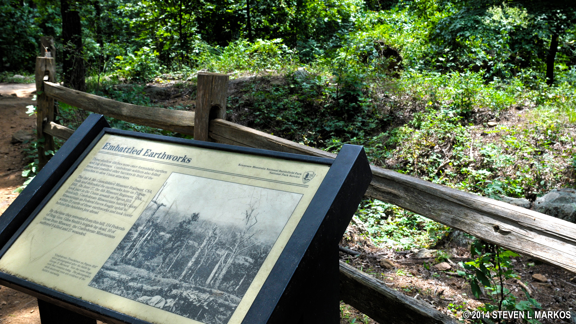
Remnants of Confederate earthworks on Pigeon Hill, Kennesaw Mountain National Battlefield Park
The Pigeon Hill Cutoff eventually becomes the Camp Brumby Trail on the eastern side of Pigeon Hill. The hike back to the Visitor Center is 2.5 miles. It is relatively easy and should take no more than 1.5 hours. Most of it follows an old, gravel fire road.

Typical terrain on the Camp Brumby Trail in Kennesaw Mountain National Battlefield Park
Camp Brumby was the name of a Civilian Conservation Corps (CCC) camp that was established at Kennesaw Mountain in the 1930s. The CCC was created by the Franklin Roosevelt administration to put men back to work during the Great Depression. Many state and national park trails, including those at Kennesaw Mountain National Battlefield Park, were built by the CCC. At the northern end of the trail is the ruins of the camp’s Educational Building. All that remains is a stone wall and a foundation or two. Wayside exhibits tell the story.

The Camp Brumby Trail at Kennesaw Mountain National Battlefield Park passes the ruins of the Civilian Conservation Corps’ Educational Building
North of the Camp Brumby site, there are two forks in the Camp Brumby Trail. The first is marked with signage that directs hikers to the Visitor Center, while the second is unmarked. I took a right at this second fork and came to an open field where the Georgia Monument is located. From the monument, it is just a couple minutes back to the Visitor Center. The left fork also goes to the Visitor Center, but the terrain is hillier and you won’t see the monument.
With a few exceptions, use of any photograph on the National Park Planner website requires a paid Royalty Free Editorial Use License or Commercial Use License. See the Photo Usage page for details.
Last updated on April 22, 2025


