

Minisink Battleground Park trail map (click to enlarge)
The National Park Service has included the short hiking trails within Minisink Battleground Park in Barryville, New York, as part of its suggested hikes for the Upper Delaware Scenic and Recreational River. There are three trails in the park. The longest, the Woodland Trail, is a 1-mile loop. The Battleground Trail, also a loop, is just .75 mile long. I did not hike the third trail, the Old Quarry Trail. It isn’t any longer than the other two, but it is an out-and-back trail, so you must double the distance. The Old Quarry Trail intersects on both ends with the Woodland Trail, so you could combine the two and make a larger loop.
All trails start at the Minisink Battleground Park Information Station. I first hiked the Battleground Trail, which is the most interesting of the three. Signs point the way to all trails, and there is directional signage at each intersection. There is no trail map that you can take with you, but you can take a photo of a trail map posted at the Information Station and refer to that as you hike. Despite plenty of directional signage, there are many places where things get confusing, so having access to a trail map will come in handy.

Information Station at Minisink Battleground Park in Barryville, New York

Start of the Battleground Trail at Minisink Battleground Park in Barryville, New York
An American Revolution battle took place here in July 1779. On the 20th, a party of 87 Tories (American colonists who supported England) and Iroquois Indians under the command of Captain Joseph Brant raided the settlement of Minisink, destroying the homes, farms, and mills. Two days later, the New York and New Jersey militia led by Colonel John Hawthorn, a group of roughly 120 men, rode out to fight Brant on the grounds of this park. The militia was prepared to ambush Brant’s men, but a rifle went off accidentally, spoiling the surprise. The Tories eventually outflanked the Americans, killing many of them. The battle was a victory for the Tories.
The Battleground Trail leads to points of interest where the fighting took place. The first part of the trail is an asphalt path that is now covered in moss. The terrain is hilly and ranges from easy to moderate in difficulty. The bulk of the battlefield is located on the high ground, so there is a fairly steep hill to the top and another when coming back down. The area at the top is level.

Terrain at the start of the Battleground Trail at Minisink Battleground Park in Barryville, New York
The first stop of interest is the Minisink Battleground Monument that was erected in 1879 on the spot where the militia made its final stand.

Minisink Battleground Monument in Barryville, New York

Minisink Battleground Monument in Barryville, New York

List of American troops killed during the Battle of Minisink in Barryville, New York
The next point of interest is Sentinel Rock. After coming under fire near the Delaware River, the Americans made a fighting retreat towards the high ground and established a square line of defense around a two-acre plot of land. Sentinel Rock marks the general location of the southwest corner of their defensive position.

Sentinel Rock at Minisink Battleground Park in Barryville, New York
The final point of interest on the hike is at Hospital Rock, the halfway point on the Battleground Trail. Eighteen militiamen, including physician Lt. Colonel Benjamin Tusten, were trapped and then killed by Brant’s forces.
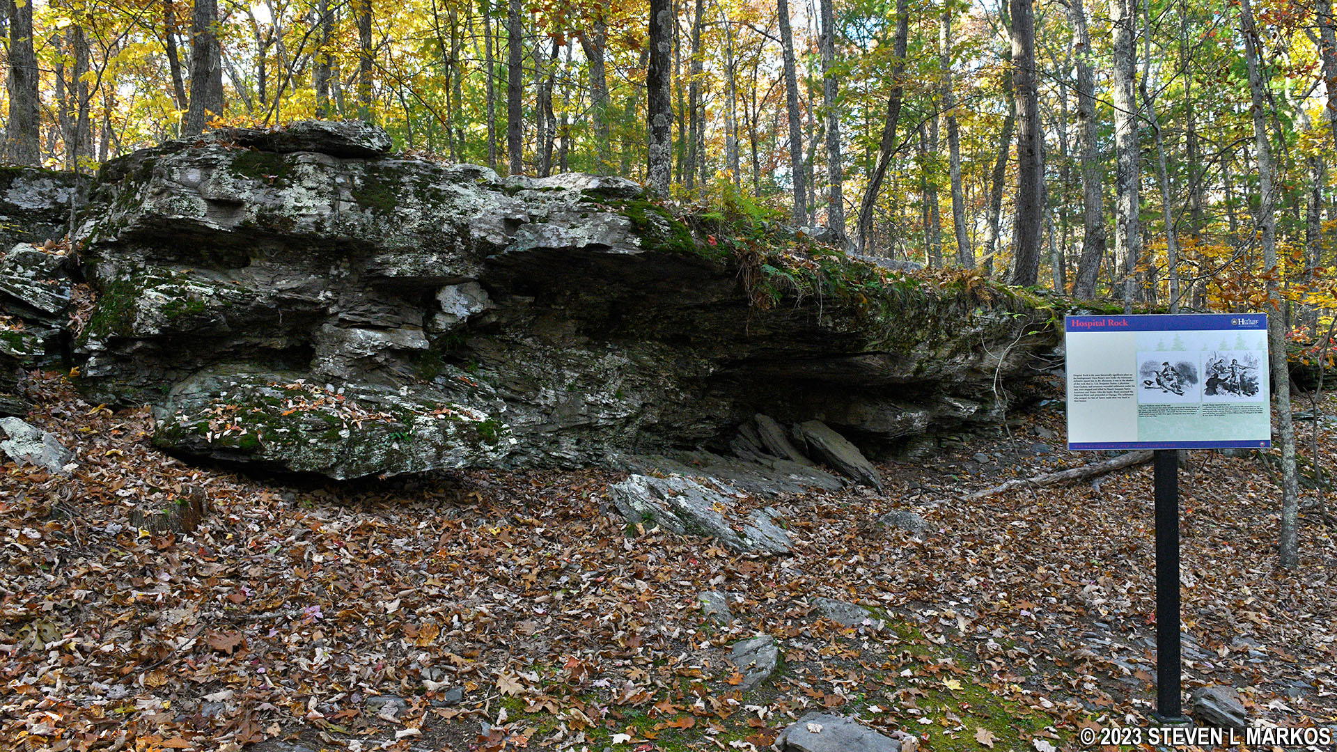
Hospital Rock at Minisink Battleground Park in Barryville, New York
The Battleground Trail ends on the other side of the parking lot from where it began.

End of the Battleground Trail at Minisink Battleground Park in Barryville, New York
After the Battleground Trail, I returned to the Information Station to begin a hike on the Woodland Trail. The terrain is similar to that of the Battleground Trail, only the hills aren’t as steep—but there are hills. The path is gravel and quite smooth, free of rocks and roots that can trip you up. There is nothing much of interest on the trail. It’s just a walk in the woods and for exercise purposes only.

Start of the Woodland Trail at Minisink Battleground Park in Barryville, New York

Typical terrain of the Woodland Trail at Minisink Battleground Park in Barryville, New York

Typical terrain of the Woodland Trail at Minisink Battleground Park in Barryville, New York
As mentioned, I didn’t hike the Old Quarry Trail. The reason is that I simply couldn’t find it. Signs point to the trail beginning behind the Information Station. Per the trail map, it then crosses to the other side of the road, but I couldn’t find a trail on the other side of the road. It was getting dark, so I just called it a day.
With a few exceptions, use of any photograph on the National Park Planner website requires a paid Royalty Free Editorial Use License or Commercial Use License. See the Photo Usage page for details.
Last updated on August 21, 2023


