
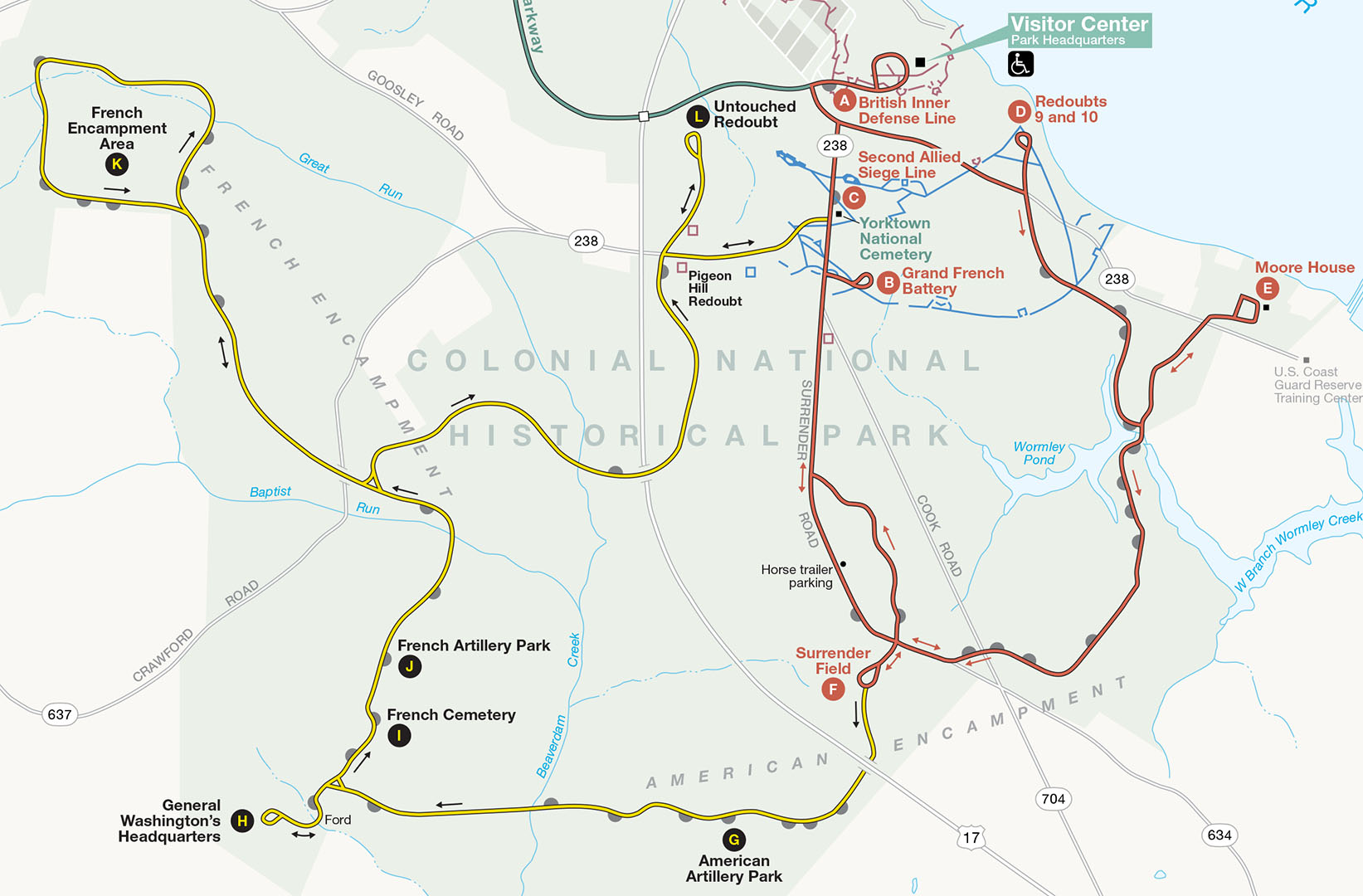
Allied Encampment Tour Map (yellow route)
A six-stop tour of the Allied Encampment area on the Yorktown Battlefield takes visitors to locations used by the American and French troops for sleeping, drilling, and storing artillery and other equipment. With nearly 15,000 men, not everyone was on the front line on a daily basis. Even when digging the trenches, a very labor intensive job, only 1,500 men were used at a time. When not fighting, the encampment area is where soldiers spent their time.
The Allied Encampment Tour starts where the Yorktown Battlefield Tour ends—Surrender Field. A one-way road leads from the far end of the paved loop parking area. The National Park Service has placed signs along the tour route that direct you to the next stop. Signs with red arrows are for the Yorktown Battlefield Tour. Signs with yellow arrows are for the Allied Encampment Tour.
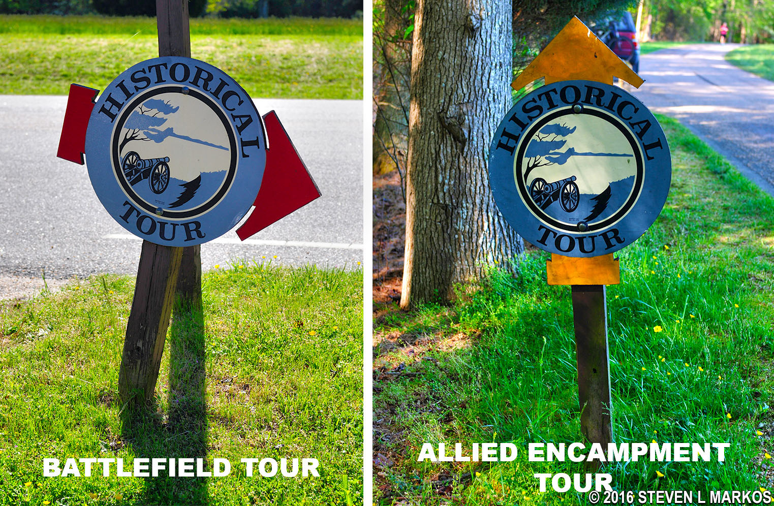
Signs for the two different tours of the Yorktown Battlefield, Colonial National Historical Park
Unlike the Battlefield Tour where many of the roads are major highways with speed limits of 55+ MPH, the roads used for the Allied Encampment Tour are lightly traveled. I do not recommend biking the Battlefield Tour, but due to the low speeds of the vehicles and light traffic, a tour of the allied camps by bike would be fairly safe. Furthermore, most of the route is flat, so it is easy to bike.
There is no CD Audio Tour as there is for the Battlefield Tour. The only source of information available is the wayside exhibits at the tour stops and a short paragraph on the free park brochure that you can pick up at the Yorktown Battlefield Visitor Center.
The Allied Encampment Tour is much different from the Battlefield Tour, and much less involving. Unlike the Battlefield Tour, which has artillery exhibits, trenches, and earthworks for you to see and explore, the Encampment Tour is almost exclusively stops marked with wayside exhibits that basically say, “So and So slept here.” If no sign were posted, you would think that you were just stopping at a spot in the forest or along a field. Thus, the appeal of the tour is limited to only those with a keen interest in the Battle of Yorktown or to those who want to stand at a place where George Washington once stood. For the most part, you are just driving through the forest.

General Washington’s Headquarters stop on the Allied Encampment Tour of the Yorktown Battlefield
The only stops that have exhibits of any type are the French Cemetery (Stop I) and the French Artillery Park (Stop J). There is also one cannon located down the road from the American Artillery Park (Stop G).

A mass grave of 50 unidentified French soldiers killed at Yorktown is located along the Allied Encampment Tour route at the Yorktown Battlefield, Colonial National Historical Park

Artillery exhibit near American Artillery Park stop on the Allied Encampment Tour of the Yorktown Battlefield, Colonial National Historical Park

Artillery exhibit at the French Artillery Park stop on the Allied Encampment Tour of the Yorktown Battlefield, Colonial National Historical Park
In addition to the six official tour stops, there are over one dozen pullouts along the road. Wayside exhibits identify regimental camp locations, officer’s headquarters, geographical landmarks, and events that took place at the location. If you want to read these signs, you can do so from your car. There are no exhibits.

Roadside pullout along the Allied Encampment Tour of the Yorktown Battlefield, Colonial National Historical Park
The only stop that requires getting out of the car and doing some walking is the last stop, the Untouched Redoubt (aka fort). This is the only original redoubt that still exists from 1781. All others have either disappeared or have been reconstructed by the National Park Service. The Untouched Redoubt was part of the British outer defenses, and it was never attacked during the Battle of Yorktown. To see it you must walk one minute down a short path. To the untrained eye it appears as nothing more than a few natural hills covered with trees. These are not natural but part of a small earthen fort. The path leads into the redoubt where you will find yourself surrounded by the small hills, the former walls of the fort. The depression you are standing in is where the troops were stationed.

Wall of the Untouched Redoubt at the last stop on the Allied Encampment Tour of the Yorktown Battlefield, Colonial National Historical Park
If you read every sign along the road and get out of your car at the six tour stops, plan to spend between 1 and 1.5 hours for the tour. In truth, if you do nothing more than pull into the parking areas and read the wayside exhibits that you can see from the car, there isn’t much point in doing the tour in the first place.
With a few exceptions, use of any photograph on the National Park Planner website requires a paid Royalty Free Editorial Use License or Commercial Use License. See the Photo Usage page for details.
Last updated on July 16, 2024


