
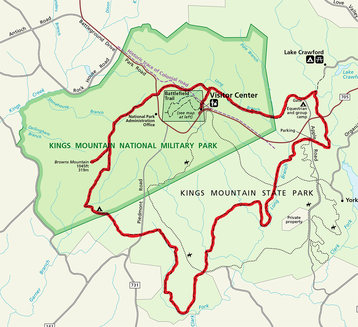
Kings Mountain National Military Park trail map (click to enlarge)
Kings Mountain National Military Park has one hiking trail, not counting the paved path around the battlefield. Called the Park Loop Trail, it is a 16-mile trail that passes through both the National Military Park and the adjacent State Park. While sixteen miles is much too long for most people, those looking for exercise might consider the 5-mile out-and-back hike from the Visitor Center to Browns Mountain.
HIKE TO BROWNS MOUNTAIN
Distance: 5 miles, round trip
Time: 3 hours
Difficulty: Moderately strenuous
The Browns Mountain Trail branches off the Park Loop Trail two miles from the start of the hike. Because this trail is in the backcountry, you must register at the Visitor Center information desk before you leave and check in when you return so the Rangers know you made it back safely. There is no charge for this.
The hike to Browns Mountain, and the Park Loop Trail for that matter, is only for exercise. The trails are not significant to the Battle of Kings Mountain, and no monuments or other artifacts about the battle are located along the trails. Furthermore, it does not offer much in the way of scenery—there’s not even a view from the top of Browns Mountain.
As one might expect from a trail with the word mountain in it, this is not a hike over level terrain. There are five large hills to climb (twice), with at least two being mountains, though using the term mountain to describe them is stretching the meaning of the word. The peak of Browns Mountain itself is only 1,025 feet high, and the final leg of the hike up the mountain starts at an altitude of nearly 800 feet. Grades do reach 15% for short stretches on each hill (a grade of 15% is the start of what most people consider strenuous hiking). Fortunately, the climbs are short. Had they been longer, I would have rated the hike as strenuous. Of course, I am a 54 year old man, so younger hikers may find it relatively easy. I saw at least four young men jogging on the trail.
Start the hike from the Visitor Center by walking out the back door and taking a right on the paved Battlefield Trail. You will come to a T-intersection in less than a minute. Take a right and continue until you see a cleared area with stacks of wood and a sign identifying the start of the backcountry trails. You can also see the parking lot from here (you can get to this point on a path from the parking lot as well).
At this point you are not actually on the Park Loop Trail, but on a connector trail that leads to the start of the loop less than two tenths of a mile ahead. When you begin the hike, you will see a gravel path that leads down a hill. This is not the trail. The connector trail is at your 11 o’clock position if you are at the trail sign. It is also marked with blue blazes, which are paint splotches on trees that you follow like Hansel and Gretel breadcrumbs. You can see a blue blaze on one of the trees if you look closely (it’s sort of faded).

Start of the connector from near the Visitor Center to the Park Loop Trail, Kings Mountain National Military Park
As mentioned, the Park Loop Trail is just up ahead, and the intersection is marked with a sign. Take a left to continue on to Browns Mountain and the park’s backcountry campsite. (NOTE: If you pay attention to the mileage given on the various park signs, you’ll find they give different distances to the same destinations. For example, the first backcountry trail sign states that it is 3.2 miles to Browns Mountain, while the sign at the start of the loop states the distance is 2.4 miles. If it is less that .2 mile between the two signs, something is up. I don’t know if the park signs are wrong or if they are measuring distances from different points that are not made clear, but my GPS confirmed that the hike to the summit of Browns Mountain is 2.5 miles, one way, from the first backcountry trail sign.)

Start of the Park Loop Trail from near the Visitor Center at Kings Mountain National Military Park
The hike is fairly straightforward, so there is not much chance of getting lost or confused. Signs point out all unexpected turns, plus the path is well marked with blue blazes and / or round hiking emblems nailed to the trees. The trail surface on the level terrain is relatively free of large rocks and roots that can trip you up. However, when you head up or down a hill there are many exposed rocks. Over the years, water rushing down the trail during rain storms has washed away the topsoil, exposing the rocks. Because of this—and because of the steep terrain in general—I recommend using hiking poles if you have them.

Typical terrain on the level portions of the Park Loop Trail at Kings Mountain National Military Park

Rocky surfaces on the hilly sections of the Park Loop Trail at Kings Mountain National Military Park
It is two miles to where the trail to Browns Mountain splits off from the Park Loop Trail. From the start, you have a 500 foot downhill hike with a 16% grade. There is a lot of loose gravel on the trail that acts as banana peels, so be careful. After that there are four hills to climb, each with a small valley in between. The first climb is just 300 feet, but it has a grade of 14%. The second is .3 mile long and is much easier, with only a 7% grade. The last hill is similar, and at the top you will be at an altitude of around 980 feet, nearly as high up as Browns Mountain. This is also the start of a very long downhill section (.6 mile) that has some steep stretches (15% grades). It doesn’t seem too bad on the way down, but you have to hike back up it on the return trip.
At the bottom of the hill is a level section that runs along a creek. To the left is a hill similar to the one you just came down. The photo below shows the trail and the hill so that you have an idea of what to expect.

Typical hill on the Park Loop Trail at Kings Mountain National Military Park
There is one last hill to climb (.3 mile / 7% grade), and after descending the short distance from the top you will find yourself at the Browns Mountain Trail intersection. Take a right to hike to the summit. It took me about an hour to get to this point, but I am pretty slow and take a lot of photos.

Intersection of the Park Loop Trail and the Browns Mountain Trail, Kings Mountain National Military Park
The trickiest part of the hike is knowing when you are at the summit of Browns Mountain. Here’s a clue: the first mountain is not it. The hike starts off up a small hill for about .2 mile, levels out for a short distance, and then climbs another tenth of a mile up to the top of the first mountain (13% grade). There is a bench at the top that makes me believe that hikers could once sit here and enjoy the view, but trees now block any such enjoyment.

Hike up the first mountain on the Browns Mountain Trail, Kings Mountain National Military Park

Trees now block the view at the top of the first mountain on the Browns Mountain Trail at Kings Mountain National Military Park
I was ready to celebrate reaching the summit of Browns Mountain when I noticed the trail continued on to what looked like another mountain peak. This second peak is Browns Mountain, and you’ll know you are at the top when you see four short cement posts, a NO CAMPING sign, and a trail sign that marks one end of the Browns Mountain Trail. When done relaxing, head back down to begin the 2.5-mile hike back to the Visitor Center.

View from the summit of Browns Mountain, Kings Mountain National Military Park
While there is no view at the summit of Browns Mountain, you do get an open window to the surrounding area on the way up. I certainly wouldn’t want to do the hike just for this, but it is as good a view as you’ll get on the hike to the top of Browns Mountain.

View on the way up the Browns Mountain Trail at Kings Mountain National Military Park
With a few exceptions, use of any photograph on the National Park Planner website requires a paid Royalty Free Editorial Use License or Commercial Use License. See the Photo Usage page for details.
Last updated on April 25, 2025


