
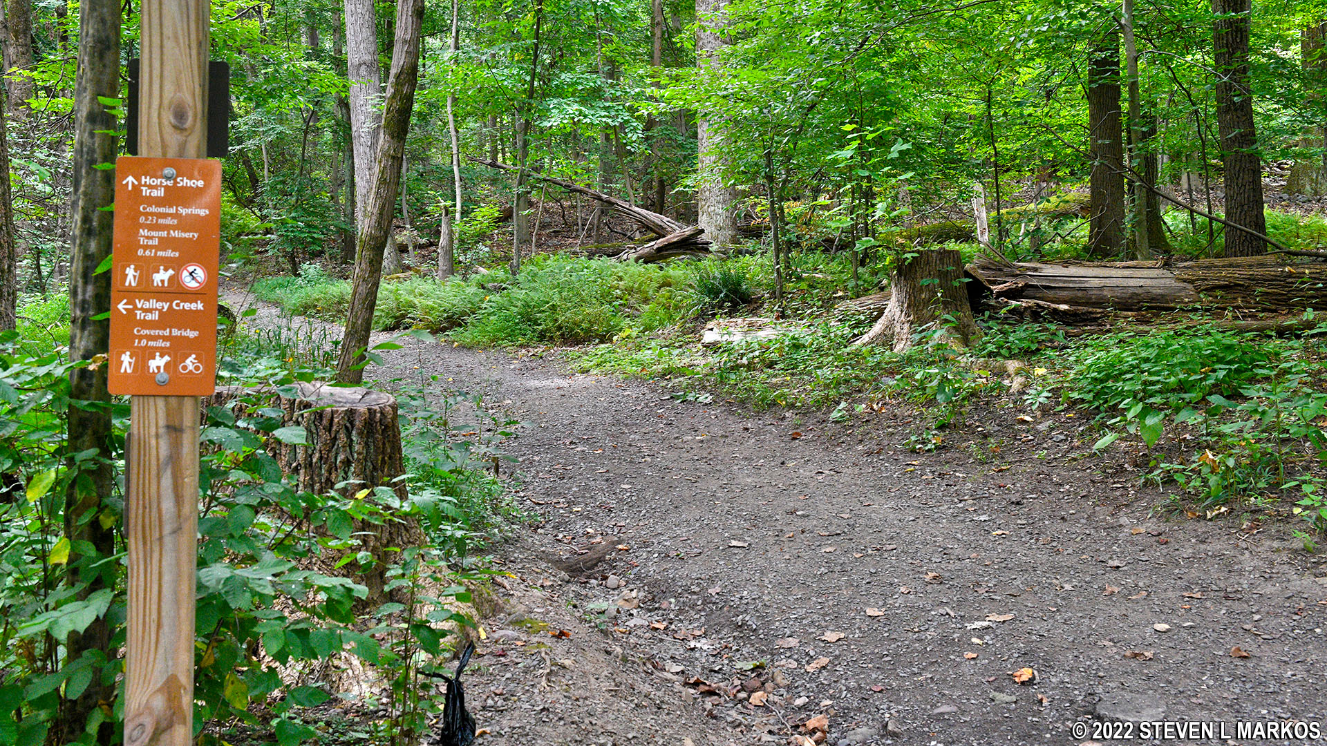
Horse-Shoe Trail at the intersection with the Valley Creek Trail at Valley Forge
Length: 1.3 miles within Valley Forge National Historical Park, 140 miles overall to the Appalachian Trail
Difficulty: Moderate
The Horse-Shoe Trail is open to hikers and horseback riders. It runs 140 miles from Valley Forge National Historical Park to the Appalachian Trail on top of Stony Mountain near Hersey, Pennsylvania. Only about a mile and a half lies within Valley Forge.
While you can reach the Horse-Shoe Trail by hiking the Valley Creek Trail or the Mount Misery Trail, the official start is at the intersection of Valley Creek Road and Valley Forge Road / Hwy 23 at the southwest corner of the Washington’s Headquarters property, one of the stops on the Valley Forge Encampment Tour. The best place to park is at Washington’s Headquarters, and if you haven’t seen the historical sites, might as well do so now. Regardless, you’ll need to get down to the southwest corner of the property where the two aforementioned roads intersect. Assuming you are on the Washington’s Headquarters side of the road, use the pedestrian crosswalk to get to the other side. A stone marker commemorates the start of the Horse-Shoe Trail.

Stone marker commemorates the start of the Horse-Shoe Trail at Valley Forge National Historical Park
Continue west on Valley Forge Road on the narrow path that leads over a bridge (at the bridge you must travel on the actual road). While bikes are generally not allowed on the Horse-Shoe Trail, they are from here up until the Valley Creek Trail intersection.

The Horse-Shoe Trail starts at Valley Forge Road near Washington’s Headquarters
Just past the bridge is a gravel road on your left, an old stone building, and a sign that points to the PATRIOTIC ORDER SONS OF AMERICA. Turn here and proceed up the road. Pass by the first left-hand turn, then stay straight (left) when the road forks 75 yards later.

Northern section of the Horse-Shoe Trail near Valley Forge Road / Hwy 23
Just past the fork is another intersection. Stay straight on the slightly narrower gravel path that bars vehicles at that point. A sign identifies it as the Horse-Shoe Trail and indicates that the intersection with the Valley Creek Trail is .2 mile ahead. There is a large bulletin board next to it with information about Valley Forge National Historical Park.

No vehicles beyond this point on the Horse-Shoe Trail at Valley Forge National Historical Park
After a few minutes’ walk there is another fork; take a right to remain on the Horse-Shoe Trail. The Valley Creek Trail intersection is just another 100 yards ahead. The Horse-Shoe Trail continues uphill to the right while the Valley Creek Trail proceeds downhill to the left. If you are on a bike, you must take the Valley Creek Trail, as no bikes are allowed on the Horse-Shoe Trail from this point on.

Northern trailhead for the Valley Creek Trail at the intersection with the Horse-Shoe Trail at Valley Forge
Unlike the Valley Creek Trail, which is a wide, gravel path and relatively level and easy to hike, the Horse-Shoe Trail is mountainous and strewn with rocks and roots that can trip you up if you aren’t paying attention. It travels uphill for most of the way with grades often between 10% and 15%. For reference, wheelchair accessible trails have grades of no more than 5%, and most hikers agree that 15% is where strenuous starts. Thus, the Horse-Shoe Trail is somewhere between moderate and strenuous, and this should be expected since it is leading up to the top of Mount Misery.

Typical terrain on the Horse-Shoe Trail at Valley Forge
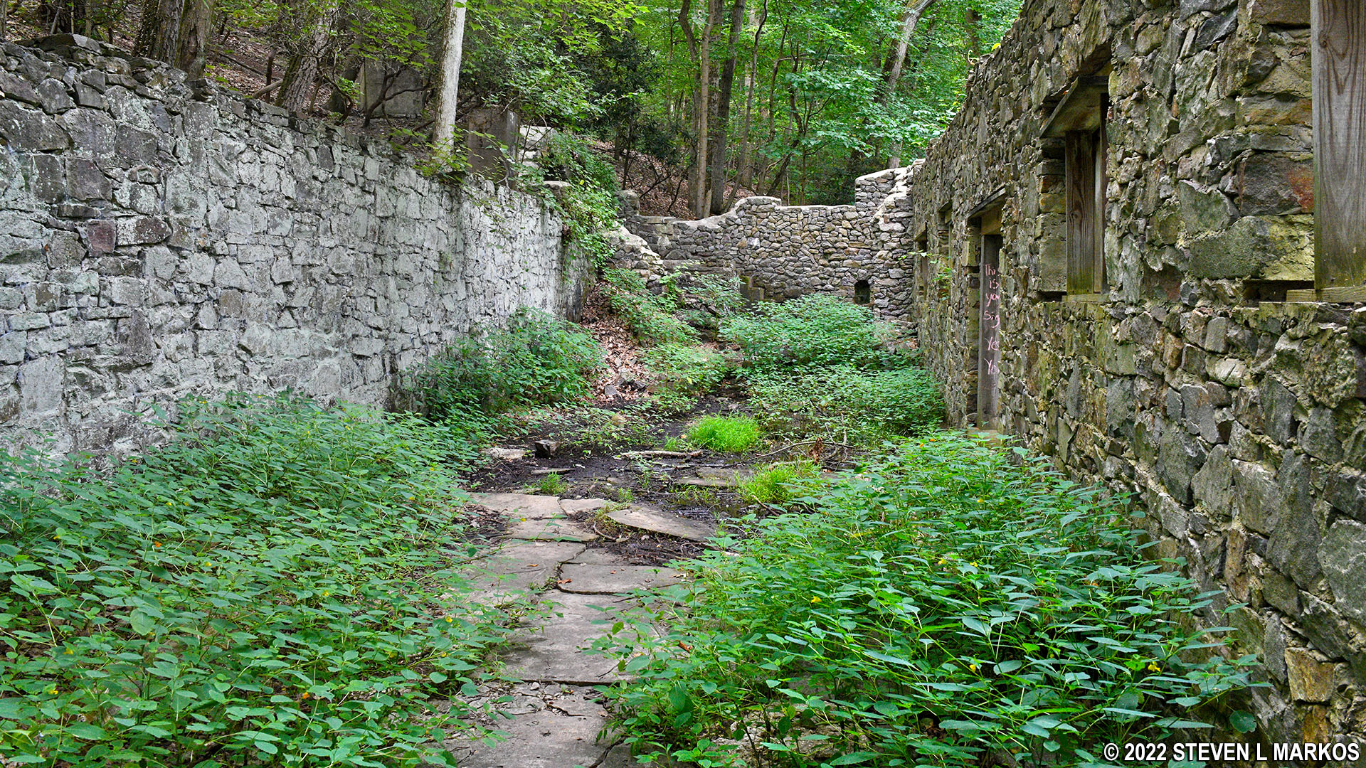
I wasn’t on the Horse-Shoe Trail for long, but the short section I did hike is full of interesting ruins, the first coming just ten minutes down the trail: a dam and retaining wall. This was built by Benjamin Franklin Fisher for a natural spring bottling plant he started up in 1886 (he was the owner of the property). There is a narrow trail that runs above the dam and a wide, gravel road that runs in front of it. I don’t know which is the Horse-Shoe Trail, but I took the gravel road. I suspect both end up at the same place: the ruins of the Colonial Spring Company’s bottling plant just up ahead.

Dam and retaining wall of the Colonial Spring Company on the Horse-Shoe Trail at Valley Forge

Retaining wall of the Colonial Spring Company’s dam on the Horse-Shoe Trail at Valley Forge
The Colonial Spring Company operated from around 1886 until 1930 (under the name Hires Bottling Plant in later years), at which time the property was purchased for inclusion in Valley Forge State Park (it wasn’t a National Park until 1976). The gravel road is the Colonial Springs Road, which connected to Nutt’s Road for the purpose of transporting the spring water off of Mount Misery. There are traces of asphalt, so the road may well have been paved at some point.

Horse-Shoe trail widens near the Colonial Spring Company’s bottling plant at Valley Forge

Ruins of the Colonial Spring Company’s bottling plant at Valley Forge
If you approach the Colonial Spring Company’s building from the northeast as I did, you’ll be tempted to enter the ruins at the first chance you get via a large stone staircase. If you do this, you’ll have to walk through a bunch of weeds to get to the other side, which is where all the cool stuff is. Instead, just keep walking up the road until you see an actual doorway that is reinforced with metal supports. Enter here and you can see everything without walking through who knows what.

Colonial Spring Company’s bottling plant at Valley Forge
Inside the ruins of the Colonial Spring Company’s building on the Horse-Shoe Trail at Valley Forge

Entrance to the Colonial Spring Company plant ruins at Valley Forge

View from inside the Colonial Spring Company’s bottling plant at Valley Forge
The natural spring still flows, and you can walk right up to it and even enter a section of the bottling plant where it comes out of the ground. Before venturing inside, note that there are large flying bugs and hundreds of spiders in there. It’s like a smorgasbord feast for the spiders.

Natural spring still flows from the ruins of the Colonial Spring Company’s bottling plant at Valley Forge

Natural spring still flows from the ruins of the Colonial Spring Company’s bottling plant at Valley Forge
When done exploring, continue down the Horse-Shoe Trail, which quickly reverts back to a narrow and rocky trail and continues up a fairly steep hill for another .4 mile until reaching the summit of Mount Misery. Again, grades are often between 10% and 15%.

Rocky terrain on the Horse-Shoe Trail at Valley Forge National Historical Park
My hike on the Horse-Shoe Trail ended at the intersection with the Mount Misery Trail. The intersection marks the top of Mount Misery, and there is a bell on the trail sign that you can ring to let the world know you summited the mountain (577 feet). See the Mount Misery Trail report here on National Park Planner for more information on this trail.

Northern trailhead of the Mount Misery Trail at the summit of Mount Misery in Valley Forge
With a few exceptions, use of any photograph on the National Park Planner website requires a paid Royalty Free Editorial Use License or Commercial Use License. See the Photo Usage page for details.
Last updated on May 31, 2022


