
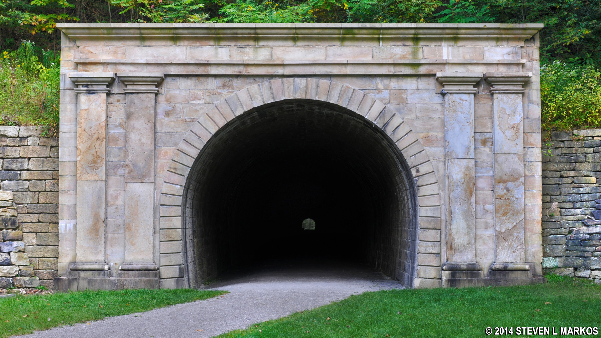
West entrance to the Staple Bend Tunnel, Allegheny Portage Railroad National Historic Site
Distance: 4.5 miles round trip (hiking and biking)
Time: 1 hour (bike), 2.5 hours (hike)
Difficulty: Flat and easy
The greatest connection to the history of the Allegheny Portage Railroad within Allegheny Portage Railroad National Historic Site is the Staple Bend Tunnel and the trail that leads to it. The tunnel is still intact and is one of the few original structures remaining today that was used by the railroad. It is America’s very first tunnel through a mountain that was used for a railroad, and only the third tunnel through a mountain at the time.
Construction began in November 1831 and finished in June 1833. During this time men worked 12-hour days with pick axes, shovels, and black powder to knock a 900-foot hole through a section of mountain located on “the level” between the top of Incline 1 and the bottom of Incline 2. This saved digging one mile of canal along a bend in the Conemaugh River. Construction started at both sides of the mountain with the objective of meeting in the middle. Progress proceeded by about 18 inches a day. It only took a year to create the hole, but another six months to fully excavate and stabilize the tunnel so it was fit for use. The ends of the tunnel had to be lined with brick so that chucks of rock would not fall onto the rail cars passing through, but most of the passageway was left raw.

Brick lined end of the Staple Bend Tunnel, Allegheny Portage Railroad National Historic Site

Raw rock interior of the Staple Bend Tunnel, Allegheny Portage Railroad National Historic Site
To reach the Staple Bend Tunnel you must hike or bike two miles from the parking lot along a gravel path. Along the way you will pass a second connection to the railroad’s history: two of over 150 drainage ditches, or “culverts,” that were dug beneath the rail path so that water would flow under the rails and not over them and cause damage. The path to the Staple Bend Tunnel offers two great views of historic culverts because side trails, though steep, branch off the main trail and take you to the lower ground. Sounds unexciting, I know. Today’s culverts are usually nothing more than concrete pipes, but back in the days of the Allegheny Portage Railroad some of them were quite elaborate and ornamental. There’s nothing really fancy about the two along this trail, but at least you can see them. The drainage tunnels have been filled in.

One of two historic culverts along the Staple Bend Tunnel Trail, Allegheny Portage Railroad National Historic Site
A third connection to the railroad’s history is that you are walking on the actual path used by the railroad. For proof, the rails went through the tunnel and you will be walking through the tunnel as well. But even better proof is the rows of sleeper stones that are still embedded in the ground along sections of the trail, which brings up a final connection to history: original sleeper stones used by the railroad.
For those unfamiliar with the concept of sleeper stones, instead of using wooden railroad ties to secure rails in place, the rails were bolted to large, square-cut stones that were embedded in the ground so they were flush with the surface. Stones were used because at the time the rail cars on the “levels” were pulled by mules and horses, not locomotives, and since the stones were flush with the ground and no obstructions ran between the rails, the animals were less likely to stumble (rails replaced the stones on the levels as the animals were replaced by locomotives). Each sleeper stone took 24 hours of labor to cut and shape, and workers created approximately 200,000 stones for the project. Since animals did not pull the rail cars up the inclines, wooden ties were used for those sections of the track. Examples of these two techniques—both stones and wood rails—can be found at the reconstructed Engine House 6 exhibit.

Rails used on the level sections of the Allegheny Portage Railroad were bolted to sleeper stones

Rails on incline sections of the Allegheny Portage Railroad used wood ties to hold them in place
Along the trail to the Staple Bend Tunnel are two, sometimes three rows of stones. Two rows were needed for one track (left and right rails), so in spots were you find three rows, the third row was used to secure one of the rails of the second track. The fourth row is missing. Where would it have gone? Who would have dug up useless sleeper stones? By the time the Allegheny Portage Railroad was closed in 1857, wooden ties were in use, not stones, so they had no resale value. Turns out that back in the mid-1900s, Bethlehem Steel ran a water line—a 4-foot diameter pipe—down the middle of the current trail and through the tunnel. A ditch was dug to bury the pipe, and any sleeper stones that were in the way were removed and rolled down the hill, so you might see piles of sleeper stones if you look into the woods next to the trail.

Two rows of sleeper stones along the Staple Bend Tunnel Trail indicate that the railroad ran on this path, Allegheny Portage Railroad National Historic Site

Close-up of a sleeper stone used on the Allegheny Portage Railroad
So now that you know about the Staple Bend Tunnel, how do you get to see it. First off, for those unfamiliar with the numbering system for the inclines of the Allegheny Portage Railroad, the numbers started on the Johnstown side of the canal. Since the Staple Bend Tunnel is located between Inclines 1 and 2, this means it is not located near the main section of Allegheny Portage Railroad National Historic Site at Incline 6 near Cresson, Pennsylvania, but near Johnstown in the town of Mineral Point, a roughly 25-mile drive from the park’s Visitor Center that takes a little over a half hour. See the Directions and Contact Information page for a map showing the tunnel’s location.
At the parking area for the tunnel is a small park with a few picnic tables and a restroom. The trail starts on the paved path that runs to the left of the restrooms and picnic tables.

Trailhead for the Staple Bend Tunnel Trail at Allegheny Portage Railroad National Historic Site
From the parking lot, a 2-mile gravel trail open to hikers and bikers leads to the tunnel. The tunnel itself is 900 feet long, about .2 mile, and of course you will want to walk through it, so the round trip is about 4.5 miles (you cannot ride your bike in the tunnel). The path is completely flat. If you can walk the distance, you can get to the tunnel. There are benches along the way. I road my bike and highly suggest this means of travel if you have one available, for it cuts a 2+ hour trip down to about an hour. Be sure to bring a flashlight with you. I walked through the tunnel without a light, so it can be done, but it would have been nice to see the interior construction. I took some flash photos, so my knowledge of the interior is from them only.

Flat gravel path of the Staple Bend Tunnel Trail at Allegheny Portage Railroad National Historic Site
When you get to the other side, if you are paying attention, you will notice something is different about the two entrances. On the east side where you first came to the tunnel, the exterior entrance is plain. On the west side where you exit, the exterior is decorated with a Romanesque façade with columns. Originally, both sides of the tunnel had the decoration. Nobody knows for sure what happened to the east side façade, but it disappeared in the 1800s.

East entrance of the Staple Bend Tunnel, Allegheny Portage Railroad National Historic Site
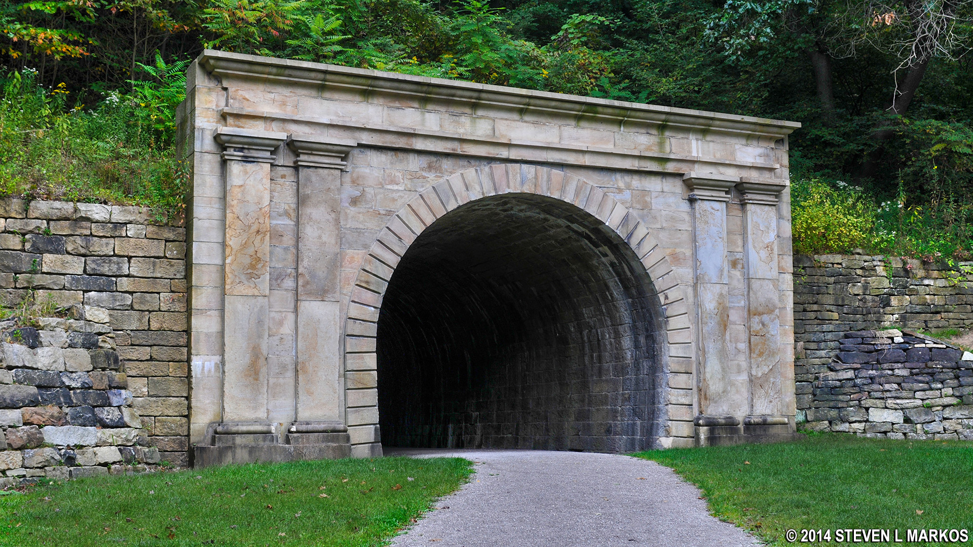
West entrance of the Staple Bend Tunnel, Allegheny Portage Railroad National Historic Site
After the railroad was closed, the tunnel and rail path were used as a popular carriage road until the Johnstown Flood. It was still used afterwards, but mainly by local residents as a “lovers lane” of sorts. In the 1940s the tunnel was closed to the public. A small section of the interior on the eastern end of the tunnel was lined with concrete, as opposed to the original brick. Water lines were installed through the tunnel and used by Bethlehem Steel. The National Park Service added the tunnel to Allegheny Portage Railroad National Historic Site in 2001 and did further renovations to stabilize the tunnel so it could once again be opened to the public.
With a few exceptions, use of any photograph on the National Park Planner website requires a paid Royalty Free Editorial Use License or Commercial Use License. See the Photo Usage page for details.
Last updated on September 12, 2023


