
Fog creates an eerie but beautiful atmosphere on the Blue Ridge Parkway’s Richland Balsam Trail
Length: 1.5-mile loop
Time: 1.5 hours, including time to read the the trail brochure
Difficulty: Moderate
It may just have been the fog, but the Richland Balsam Trail ended up being one of my favorite trails on the Blue Ridge Parkway, and I normally hate hiking in the forest. To begin with, you are hiking at one of the highest elevations on the Parkway at over 6,000 feet, so that alone brings a new type of ecosystem not found anywhere else on the Parkway. The trail cuts through a spruce-fir forest, which gives it the feel of an alpine hike, and when you get a whiff of the Fraser Fir trees, you can’t help but think it’s Christmas time. If I were blindfolded and dropped into this forest, I never would have guessed that I was hiking in North Carolina.
The trail begins on a paved path at the left side of the Haywood-Jackson Overlook parking lot. Keep in mind that you are hiking to the summit of Richland Balsam Mountain, so half of this hike is uphill. The trail starts off at an elevation of 6,020 feet and ends at around 6,400 feet. However, it uses a system of switchbacks so that the climb is gradual and never strenuous.
The Richland Balsam Trail is what is called a “nature trail,” which means there are numbered markers along the trail, and if you have a trail brochure you can read about the plants and animals you might see near a particular marker. There is a box at the start of the trail where a lone, laminated brochure possibly awaits. I say “possibly” because who knows if it will be returned each time it is taken. Furthermore, if somebody else is hiking the trail and using the brochure, you are out of luck. I wouldn’t worry too much about it, for while there is some good information, the brochure was written many years ago and has never been updated. At one stop it talked about the rhododendrons, but there weren’t any rhododendrons anywhere in the area.

Numbered posts mark stops along the Blue Ridge Parkway’s Richland Balsam Trail
The pavement quickly ends and the trail becomes a gravel path until you get to the start of the loop portion of the trail, about .15 miles from the parking lot. Being a loop you can go either clockwise or counterclockwise, but the numbered markers are set up chronologically in the counterclockwise direction, so take a right at the intersection. At this point the trail becomes narrow and dark, often walled in by trees like something right out of the Wizard of Oz. You may even find yourself whispering, “Lions and tigers and bears, oh my.”

The narrow path of the Blue Ridge Parkway’s Richland Balsam Trail is walled in by trees at some spots
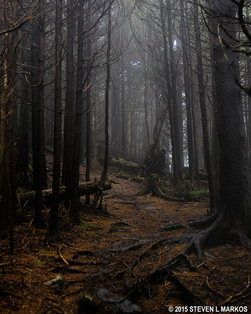
In the early 1900s a bug known as the balsam wooly adelgid was introduced to the United States from Europe. These insects feed on and kill balsam and Fraser fir trees, usually ones about 15 to 20 years old. When the tree dies and falls, it makes room for new fir trees to grow, but there are no large, older trees. By the 1970s it had reached the forests along the Blue Ridge Parkway. Due to the carnage caused by this insect plague, there are a lot of downed trees and rotting logs along the trail, which adds to the unique atmosphere. The needles from dead trees are so thick in areas that when you walk you barely make a sound. It’s an eerie but peaceful hike, at least in the fog. I don’t know how it would be on a sunny day.

Much of the Blue Ridge Parkway’s Richland Balsam Trail near the summit is carpeted with fir tree needles

Remnants of dead fir trees are common on the Blue Ridge Parkway’s Richland Balsam Trail
The trail levels out towards the top, then makes one last, steep push right before reaching the summit, which comes about .6 mile into the hike. The summit is marked with a sign.
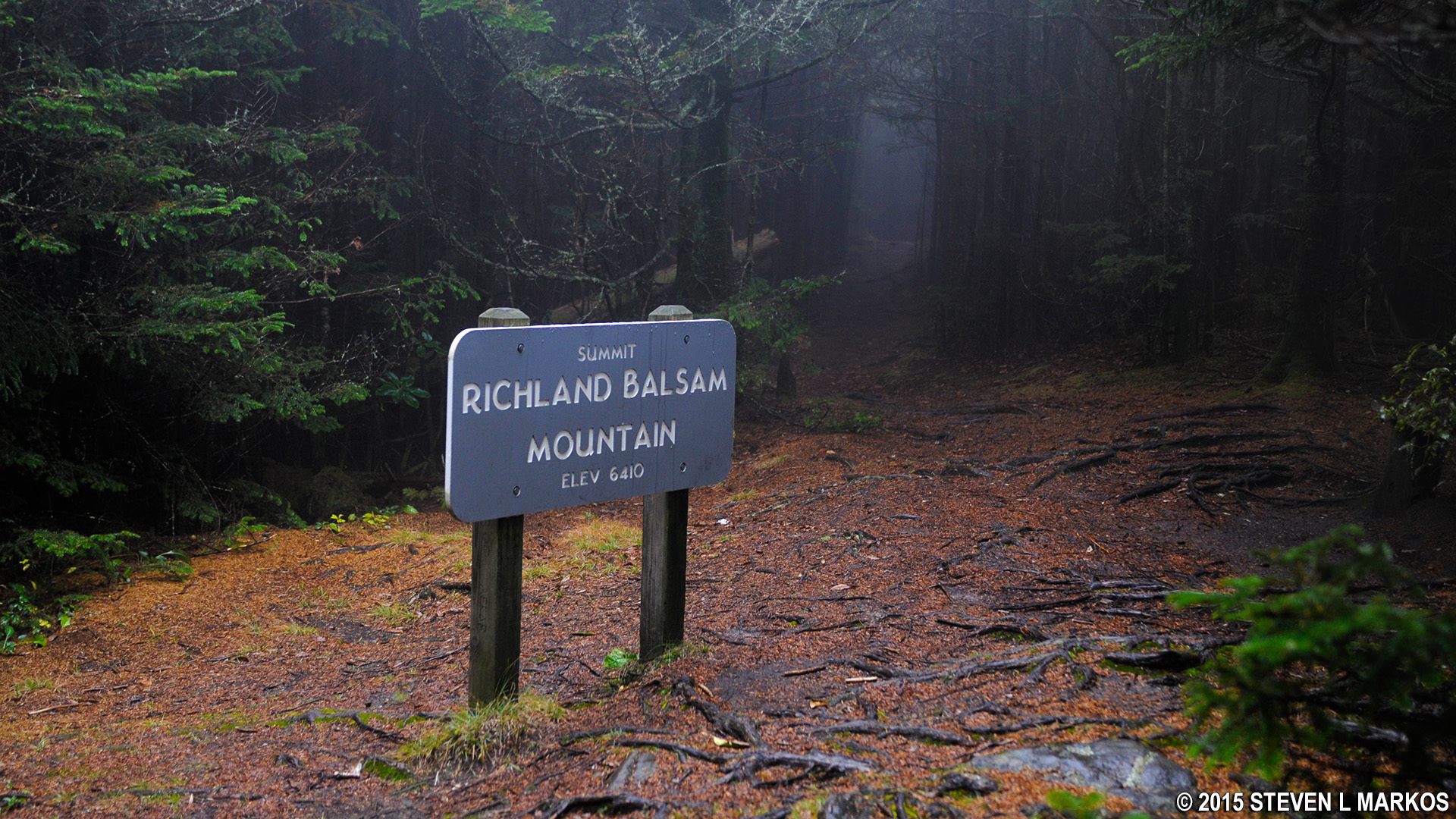
Summit of Richland Balsam Mountain near the Blue Ridge Parkway
As you may have guessed, once you pass the summit the trail begins its descent back to the parking lot. Maybe it was my imagination, but it seemed a lot steeper going down than coming up, so the decision to hike in the counterclockwise direction was a wise one. If the trail is wet, the rocks and roots along the path will be slick, so hiking boots and poles are highly recommended. I slipped a number of times even with boots and poles. Surprisingly, the roots are more slippery than the rocks.

Rough terrain along the Blue Ridge Parkway’s Richland Balsam Trail on the way down the mountain
At the one-mile point, which is about where you see the post for Stop 19 on the trail, the terrain becomes much smoother, and by the time you get to the last post, #22, the trail is fairly flat and the forest thins out. It took me about an hour and a half to complete the hike, but I did stop to take many photos and read all of the trail brochure. You could probably knock off 20 minutes from the hike if you don’t stop to read the info. If you have the trail brochure, be sure to put it back in the box at the start of the trail.

After an hour and a half of hiking the Richland Balsam Trail, the fog on the Blue Ridge Parkway still had not lifted
With a few exceptions, use of any photograph on the National Park Planner website requires a paid Royalty Free Editorial Use License or Commercial Use License. See the Photo Usage page for details.
Last updated on December 5, 2023


