

Great Island Trail Map (click to enlarge)
See the Hiking Trails web page for an interactive location map.
Length: 8 miles round trip (to Jeremy Point Overlook)
Time: 4.5 hours
Difficulty: Moderate
Note: Though part of the mainland today, Great Island was once an actual island. Silt deposits caused it to reconnect to the mainland in the 1830s.
The Great Island Trail is the longest hike at Cape Cod National Seashore and the only trail for serious hikers. It is hands down the best hike in the park, and probably the best National Seashore trail in the National Park System except for a few trails at Point Reyes National Seashore in San Francisco. You have views of the Herring River, Wellfleet Harbor, grassy plains, sand dunes, and Cape Cod Bay, so bring your camera for some of the best shots at Cape Cod.
There are four points of interest along the trail: Great Island Tavern Site, Great Beach Hill, Jeremy Point Overlook, and Jeremy Point. I set out to hike to Jeremy Point Overlook, with a side trip to the Great Island Tavern Site, a distance of 8 miles. The best way to accomplish this is to hit the tavern site on the way out, then hike directly back to the parking lot from the overlook. If the tide is out, when you get to the overlook you can continue south all the way to Jeremy Point itself along a very narrow stretch of land—basically a long sandbar—that runs approximately 1.4 mile, one-way. I did not do this, as 8 miles was enough for me.

Satellite view of Jeremy Point
Parking for the Great Island Trail is near the corner of Griffin Island and Chequessett Neck roads. There is a main parking lot and an overflow parking area; there is no charge to park in either of these. The trailhead is located at the far end of the main parking lot. If you need to use the restroom before setting off, there are two portable toilets available.
The Great Island Trail is not the best marked trail, so be sure to pick up a trail guide at the brochure box located at the trailhead. It tells about the history of the area, and more importantly, it has a rudimentary trail map. The route I ended up taking doesn’t exactly match that on the map, so even with the guide I still managed to get off course. If you are at the Province Lands Visitor Center before the hike, be sure to get a guide there just in case the box is empty.

Start of the Great Island Trail at Cape Cod National Seashore
I hiked the Great Island Trail in late July and was harassed by biting flies that were smart enough to hang around at my ankles where I couldn’t swat them easily. The trail also passes through grassy areas where ticks tend to live, so I recommend wearing long pants. This will also protect your legs from potential poison ivy lurking in the wooded areas.
The hike starts off on a mild descent through the forest towards what is called The Gut, a stomach-shaped section of the Herring River. It is only a five minute-walk to the water. For those who want to do some paddling on the river, a canoe launch is off to the left. The hiking trail continues to the right.

Stairs lead down to “The Gut” on the Herring River, Cape Cod National Seashore
The trail winds along the base of the sand dunes on a wide, hard-packed-sand surface. You will be out in the open—in fact, most of the hike is out in the open—so wear a hat and apply sunscreen if avoiding the sun is important to you.

Hard packed, sandy trail surface at the start of the Great Island Trail at Cape Cod National Seashore
At the half-mile point the terrain turns from hard-packed sand to deep beach sand and remains that way for most of the next half mile. If you have ever hiked on sand, it’s like taking two steps forward and one step backward. Expect your pace to slow by at least 50 percent. There is also a fork to the right that leads to the beach on Cape Cod Bay, the first of two beach access trails. You can actually walk all the way to Jeremy Point right along the water. If you have a dog, you must go this way, as dogs are not allowed inland due to birds and other animals that live in the grassy wilderness. To get to the Great Island Tavern Site, stay to the left. Do not proceed to the beach.

The hike through deep sand on the Great Island Trail begins at the first beach access area, Cape Cod National Seashore

Beach sand along a section of the Great Island Trail at Cape Cod National Seashore
In roughly another half mile the trail forks once again, with a clearly defined path to the right and what looks like a path worn through a field by lost hikers to the left. This is the start of the side trip to the Great Island Tavern Site. There is a sign in the distance that is too far away to read, which is sort of silly since it is a direction sign and should be posted at the fork. To get to the tavern site, take a left. If you just want to hike to the Jeremy Point Overlook, stay to the right.

Fork on the Great Island Trail marks the start of the trip to the Great Island Tavern Site at Cape Cod National Seashore
The trail now follows the Herring River shoreline, and at times you could jump right in the water. The trail surface is still loose beach sand, but it’s not as deep as it was before the turnoff for the tavern site.

Cape Cod National Seashore’s Great Island Trail hugs the shoreline of the Herring River

Herring River near the confluence with Wellfleet Harbor, Cape Cod National Seashore
At .7 mile from the fork, the trails turns away from the beach and heads up a steep sand dune. A sign points the way to the Great Island Tavern Site.

Great Island Trail continues up a steep sand dune to the Great Island Tavern site at Cape Cod National Seashore
At the top of the dune you have the option to make a left and take a detour out to the point at the confluence of the Herring River and Wellfleet Harbor, which also can be accomplished by simply following the shoreline and not scaling the dune in the first place. It’s a quarter-mile round trip that leads to some nice views. The trail actually continues past the point, but eventually dead ends, so turn around once you get to the point.

Detour from the Great Island Trail to the point at the confluence of the Herring River and Wellfleet Harbor, Cape Cod National Seashore

Point at the confluence of Wellfleet Harbor and the Herring River, Cape Cod National Seashore
To continue on the Great Island Trail, take a right at the top of the sand dune, following the sign that reads To Trailhead (Parking Lot). This is a little confusing since you want to go to the tavern site and not back to the parking lot, but all it means is that the trail eventually loops back to the main trail where you can continue to Jeremy Point Overlook or head back to the parking lot. It passes the Great Island Tavern Site along the way.

Route of the Great Island Trail to the Great Island Tavern Site at Cape Cod National Seashore
The trail follows a bluff overlooking the river for a short distance, so you’ll have a chance to get some nice photos.

View of Herring River from a small bluff above the water on the Great Island Trail at Cape Cod National Seashore
Just a few minutes ahead is a wayside exhibit with archaeological photos of the Great Island Tavern Site. Unfortunately, nothing remains of the tavern, so the sign is ultimately the highlight of the detour. The tavern operated from 1690 to 1740, catering to the local fisherman who lived on Great Island, many of them whalemen. In the early days of whaling on Cape Cod, whales were hunted close to shore. When spotted, a small boat traveled out to the whale and men tossed a few harpoons into it, then dragged it back to shore for processing. However, whales that ventured close to shore were eventually exterminated, and the men had to travel farther and farther to find them. That spelled the end for the tavern, for most of the men joined whaling voyages that lasted two to four years and no longer lived full time on the island.

Wayside exhibit at the site of the Great Island Tavern, Cape Cod National Seashore
The wayside exhibit indicates that the trail continues to the left where it enters a pitch pine forest, giving hikers a respite from the sun. The pine trees are short and twisted, sort of like bonsai trees. Try to stay away from the vegetation to avoid ticks and poison ivy. Oddly enough, another sign claims that the Great Island Tavern Site is still ahead. Since there is nothing to see in the first place, I wouldn’t know if it was ahead or back at the previous wayside exhibit. There never is a definitive “X Marks the Spot” sign, and there certainly isn’t any noticeable archaeological site in the area.

Great Island Trail at Cape Cod National Seashore passes through a pitch pine forest
Around 2.5 miles into the hike the trail dead ends into a T-shaped intersection. This is not on the trail map and no signs indicate which way to turn (this is not the intersection with the main trail, which is still up ahead). The correct way to proceed is to the right, but you can turn left and make a short detour to a beautiful overlook of Wellfleet Harbor. Here you will find one of the best photo opportunities on the hike.

Wellfleet Harbor overlook on the Great Island Trail at Cape Cod National Seashore
The intersection with the main trail is a quarter mile ahead. Take a left to continue to Jeremy Point or a right to return back to the parking lot. A sign points the way.

Great Island Trail to Jeremy Point, Cape Cod National Seashore
The trail now continues through the forest on a wide, sandy trail. This isn’t beach sand, so you should not be slowed down.

Typical terrain on Cape Cod National Seashore’s Great Island Trail through the pitch pine forest
Minutes later the trail spills back out into the open where it crosses a grassy plain and a few rolling sand dunes over the next twenty minutes. The trail surface also resorts back to beach sand.

Heading south to Jeremy Point on the Great Island Trail at Cape Cod National Seashore
At four miles into the hike is a second beach access area. It is also at this point where the trail reaches the base of Great Beach Hill, a monstrous sand dune that is extremely difficult to climb due to the loose sand.

Climbing Great Beach Hill on the Great Island Trail, Cape Cod National Seashore
Once at the top of Great Beach Hill, the trail reenters the forest. There is another unmarked intersection with a NO PETS sign posted. I stayed straight, but I now believe this might be where I strayed from the official route. I didn’t take a right because the trail looked overgrown, whereas straight ahead was obviously well traveled.
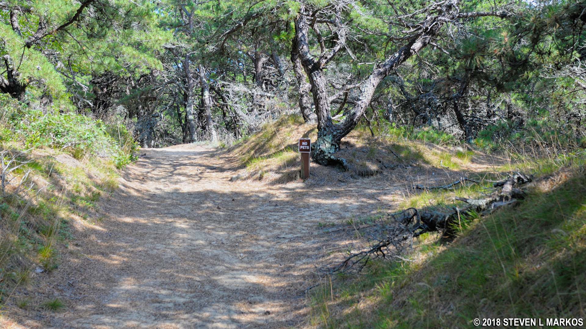
Unmarked intersection on the Great Island Trail at the top of Great Beach Hill, Cape Cod National Seashore
The Great Island Trail cuts across Great Beach Hill towards the Wellfleet Harbor side, then descends back down to sea level, emerging from the forest as it does so, and promptly begins curving west towards Cape Cod Bay on the other side of the peninsula. I never saw anything that remotely looked like an overlook, so I’m guessing that back in the 1960s when Cape Cod National Seashore first opened that Great Beach Hill had no trees on it, thus allowing people to see down to Jeremy Point. Either that or I went the wrong way.

Typical terrain at the southern end of Cape Cod National Seashore’s Great Island Trail as it curves towards Cape Cod Bay
The trail finally hits the beach a quarter mile later, 4.8 miles from the start. As mentioned earlier, if the tide is out you can walk south all the way to Jeremy Point, an extra 2.8 miles, round trip. I ran into a woman who was returning from the point, and she reported that the walk was pretty much just more of the same. I hadn’t planned on hiking down there to begin with, so her report eased my fears that I might be missing out on something spectacular. Keep in mind that if you are at the point when the tide comes in, it’s not like being on a beach where you have to move back farther from the water. It’s like being on an island that ends up submerged. You’ll either be swimming or wading back to the overlook area.

Beach access area at the south end of the Great Island Trail at Cape Cod National Seashore
The return hike is along the seashore until you reach the first beach access area, at which point you cross back over the dunes and merge with the inland hiking trail. If you want to minimize your hike on the beach, you have the option to jump back on the hiking trail at the second beach access area near the foot of Great Beach Hill.
As you head north, the giant hill to your right is Great Beach Hill. From here it is clear just how large it is—75 feet high at its tallest point. With its various shades of beige, it is similar to hills found at Death Valley and the Badlands. This is some of the prettiest scenery at Cape Cod National Seashore.

Hiking the Great Island Trail along the side of Great Beach Hill at Cape Cod National Seashore

Various shade of beige color Great Beach Hill at Cape Cod National Seashore
As it turned out, the beach between the two access points was closed due to shorebird nesting when I visited, so I was forced to rejoin the hiking trail at the second beach access point. I had less than a half-mile walk along the beach.

Beach Closed sign on Great Island at Cape Cod National Seashore
To get back to the parking lot, all you have to do is follow the signs. It is roughly three miles from the base of Great Beach Hill.

Hike back on the Great Island Trail to the parking lot on familiar terrain, Cape Cod National Seashore
With a few exceptions, use of any photograph on the National Park Planner website requires a paid Royalty Free Editorial Use License or Commercial Use License. See the Photo Usage page for details.
Last updated on February 21, 2024


