

North and South Bubble as seen from the Jordan Pond House in Acadia National Park
NOTE: The following trail review discusses the slope of the trail, which is called a grade. This is not the angle of the slope, but the calculation of rise (climb in elevation) divided by run (length of horizontal progress) expressed as a percentage ((rise/run) x 100). For example, using feet as the unit of measurement, a 10% grade means that a trail climbs 10 feet for every 100 feet in length. Positive grades are inclines and negative grades are declines; National Park Planner uses positive numbers in all cases, but gives a written indication of whether a slope is uphill or downhill. The grade given for an entire trail is an average, so mountainous trails may have sections with extremely steep grades as well as level areas. For reference:
- A wheelchair accessible trail has a grade of no more than +/-5%
- Most recreational trails are designed to be no more than +/-10%, with a steeper segment every now and then
- Most people agree that a +/-15% grade is where things begin to get really steep
- Stairs in a typical house and the steepest ski slopes have a grade of 60%
- A 45º angle is equal to a grade of 100%
- A stepladder has a grade of 260%
- A wall perpendicular to the ground (straight up) has a grade of infinity
To put Acadia National Park mountain trails into perspective, the average grade from the first Nepal base camp to the summit of Mount Everest is 17%, while the average grade from South Col (final camp) to the summit is 60%. Average grades of many trails in Acadia exceed Everest’s 17%, and short stretches go way beyond 60%. The difference, aside from ice and snow, is that the 60% grade of the South Col to Everest summit hike covers 3,100 vertical feet and lasts for a mile, whereas a 60% grade at Acadia may last a few hundred feet. The tallest mountain in Acadia is only 1,530 feet, so even if the grade was 60% from bottom to top, the hike would still only be half as long as the Everest summit hike.
BUBBLES TRAIL AND JORDAN POND PATH LOOP HIKE
Length: 4.6-mile loop from the Jordan Pond House
Time: 4 hours
Difficulty: Jordan Pond Path is easy; Bubbles Trail is strenuous
The Bubbles are two mountains at the north end of Jordan Pond in Acadia National Park. There are numerous ways to reach them, but I began my hike from the Jordan Pond House because I also wanted to hike around the pond. This combination offers a wonderful hiking option if you have the time.

Bubble Hike map (click to enlarge)
The hike starts off along the Jordan Pond Path, which you can pick up at a number of locations from the Jordan Pond House. I began from the house lawn where guests dine for lunch on tea and popovers. This is an easy hike along a well-manicured gravel trail that follows closely to the shoreline.
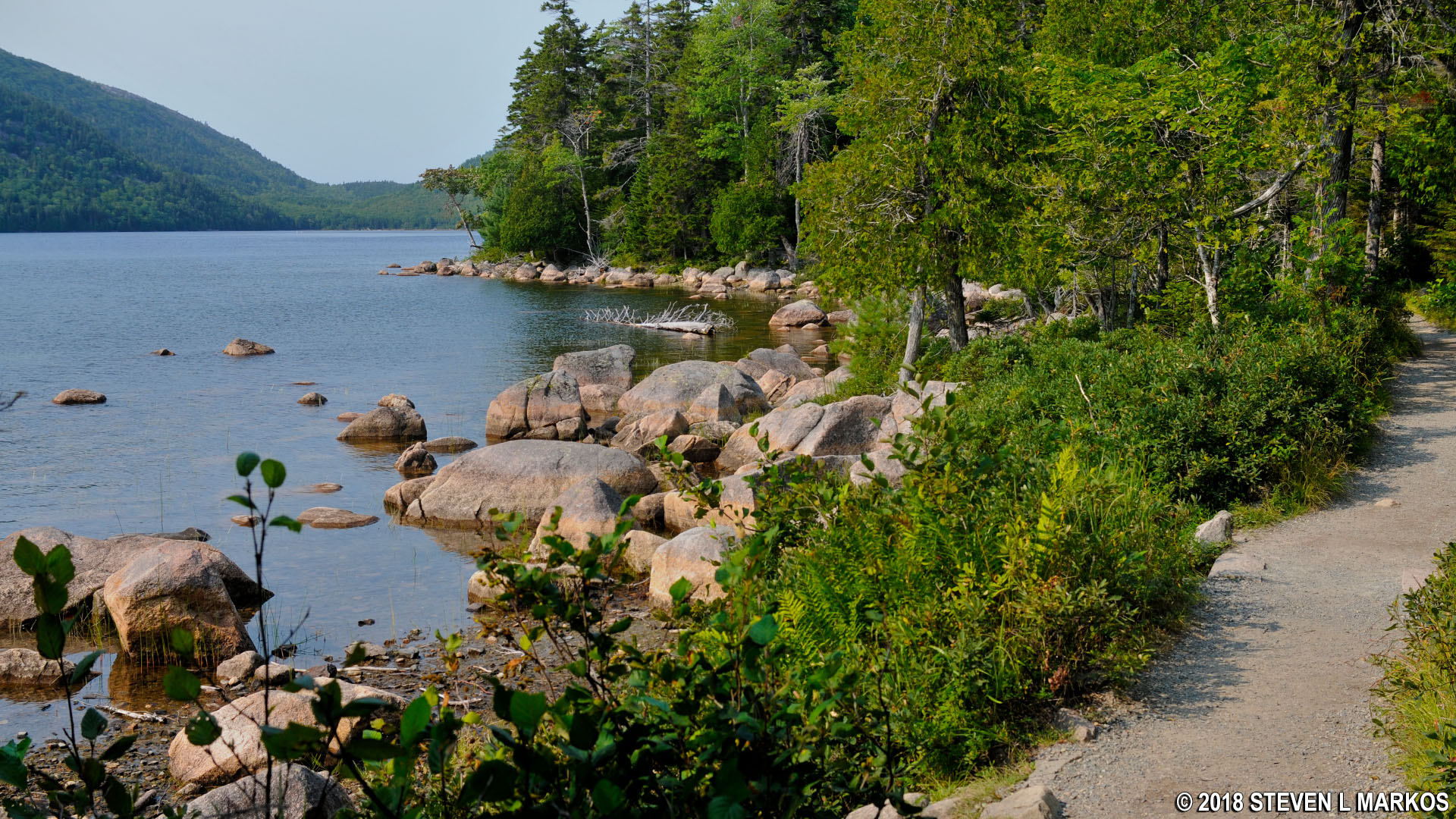
Jordan Pond Path, Acadia National Park
After a quarter mile you will come to an intersection with the Bubble and Jordan Pond Path Trail. This is an actual name for a trail, and it has nothing to do with the Bubbles Trail or the Jordan Pond Path, so I don’t know why it was given a name that would cause confusion. Anyway, skip it and continue walking around the pond. In another mile you will come to the real turnoff for the Bubbles Trail at a footbridge that spans a small feeder stream.

Footbridge at the intersection with the Bubbles Trail and Jordan Pond Path at Acadia National Park
There are actually two trails at this intersection, one that leads to a parking area on the Park Loop Road and one to the Bubbles Trail itself. Destinations are indicated on a sign.

Start of the Bubbles Trail near Jordan Pond, Acadia National Park
The first destination is the South Bubble. The trail to the summit rises 450 feet in .4 mile, a grade of 21%, one of the steepest in Acadia National Park. Keep in mind that this is the average and that short sections frequently have grades between 30-70%. Its only saving grace is that it’s not even a half mile to the top.
The start of the hike is almost comical. I see the rockslide, but where’s the trail? Well, the rockslide is the trail, and the photo below is not the result of trick photography. To follow the correct route, it is important that you understand how the trail is marked. Blue paint splotches called blazes are either painted on the rocks or on the trees. These function as Hansel and Gretel breadcrumbs, so when in doubt as to which way to go, look for the blazes. In areas where there are no trees, cairns are also used to mark the trail. These are distinct piles of rocks placed on barren surfaces. You typically can see from one blaze or cairn to the next, and if not, you should see one within a few minutes of hiking if you are going in the right direction.

Terrain at the start of the Bubbles Trail in Acadia National Park
Stairs have been made out of some of the rocks, so the hike through the rockslide isn’t as bad as it looks. The result is similar to walking up steps in a stadium.

Stone staircases on the Bubbles Trail make the hike a little more tolerable, Acadia National Park
When you get towards the top, there is a Fat Man’s Squeeze that requires actual rock climbing. I had to remove my backpack and water bottle holder on my hip in order to squeeze through. There is nothing to get your feet into, so you must hoist your entire body up and over this obstacle by using your arms only.

Fat Man’s Squeeze on Acadia National Park’s Bubbles Trail
Just before the Fat Man’s Squeeze is the first clear view of Jordan Pond. Nothing changes much as the trail ascends, other than some of the trees that block the view disappear at the higher elevations. While called a pond, this is a lake in my book. A pond is small and clear enough to see the bottom. Jordan Pond is 150 feet deep.

View of Jordan Pond from the Bubbles Trail at Acadia National Park
There are a couple of other rock climbing opportunities, all very strenuous and steep, including one with iron rungs built into the granite wall.

One last rock wall to climb on the Bubbles Trail at Acadia National Park
Once at the top, keep hiking until you reach the summit marker, a sign that states the elevation (768 feet). From the Jordan Pond House lawn to the summit is 1.6 miles.

View of Jordan Pond from the top of the South Bubble, Acadia National Park
There is another attraction at the top of the South Bubble: Bubble Rock. Take a detour on a short trail that leads to a giant boulder that is miraculously glued to the edge of the mountain slope. The detour is only a tenth of a mile round trip and slightly downhill. You do have to return to the main trail to continue the hike.

Bubble Rock on the South Bubble at Acadia National Park
The trail to the North Bubble continues around the right side of the marker for the summit.

Trail to the North Bubble at Acadia National Park
The hike begins downhill along terraced steps, so it’s pretty easy. You’ll reach the next destination in .2 mile, the intersection with the Bubble Divide. This trail leads back down to Jordan Pond if you take a left, or to the parking lot if you turn right. The Bubbles Trail does not actually continue straight at this intersection, so you must make a short jog to the right on the Bubble Divide towards the parking lot. Destinations are indicated on the trail sign at the intersection.

Terrain between the South Bubble summit and Bubble Divide trail at Acadia National Park
You don’t travel a tenth of a mile down the Bubble Divide before coming to the intersection where the Bubbles Trail resumes. Make a left to head towards the North Bubble. The hike to the top is about as easy a summit hike as you will find in Acadia National Park. It is rocky, but someone in good shape could actually sprint to the top. The distance is a quarter mile from the intersection (.6 mile from the South Bubble summit).

Terrain on the hike to the summit of the North Bubble, Acadia National Park

Terrain on the hike to the summit of the North Bubble, Acadia National Park
The North Bubble summit is also marked with a sign that indicates its elevation (872 feet). There is another view of Jordan Pond from here. In fact, Jordan Pond is the only interesting view you get from either mountain summit, and the one from the South Bubble is the better of the two.

Summit of the North Bubble in Acadia National Park

View of Jordan Pond from the North Bubble, Acadia National Park
There are three hiking options from the top of the North Bubble. You can continue north to Connors Nubble and return via the Eagle Lake Trail, which I did not do. The two other options involve hiking back to the Bubble Divide. One is to return to the parking lot if that is where you began your hike (.3 mile down the side of the mountain). If you parked at the Jordan Pond House as I did, then you’ll want to take the Bubble Divide down to Jordan Pond and complete the loop.
Once back at the original intersection of the Bubbles Trail and the Bubble Divide, take a right, heading away from the parking lot. The first half of the trail is along another rockslide and is nearly identical to the terrain at the start of the hike to South Bubble. For those with bad knees, expect them to take a pounding when stepping down from boulder to boulder. About halfway down, the large boulders disappear, but the trail remains full of smaller rocks.

Terrain on the upper portion of the Bubble Divide, Acadia National Park

Terrain on the lower portion of the Bubble Divide, Acadia National Park
It is .3 mile to the Jordan Pond Path. Take a right at the intersection to continue the loop hike; a left takes you back the way you originally came.

Intersection with the Bubble Divide and Jordan Pond Path at Acadia National Park
Just past the Bubble Divide intersection is a creek that flows into Jordan Pond on the north side. A small footbridge spans the creek.

Footbridge over a small creek at the north end of Jordan Pond, Acadia National Park
The west side of the Jordan Pond Path is no cakewalk like the east side. The trail runs below the cliffs of Penobscot Mountain, and plenty of rockslides have occurred throughout history. The trail doesn’t start off too badly, but wait until you get farther down.

Start of the rocky terrain on the west side of Jordan Pond at Acadia National Park
You will eventually come to areas where rockslides have completely covered the trail. The first instance has been fixed up so that the rocks are flat and you don’t have to step up and over them that often.

First rockslide on the Jordan Pond Path at Acadia National Park
However, the second rockslide almost forces hikers into the water.

Jordan Pond Path nearly falls into the pond at a second rock slide, Acadia National Park
Just after the second rockslide, the shoreline makes a big curve to the left, and from this point on much of the trail is along an elevated boardwalk. I’m not sure if this is to keep hikers out of wet terrain or above the rocks and roots on the trail. Some of the planks are a little wobbly, so be prepared to be thrown off balance from time to time. The planked trail runs nearly all the way back to the start. It is only on the last quarter mile that the trail once again becomes a well-manicured gravel path.

Plank boardwalk runs along most of the southwest end of the Jordan Pond Path at Acadia National Park
For those who want an easier hike to the summit of the Bubbles, use the Bubbles Divide starting from the parking lot on the Park Loop Road. From the intersection with the Bubbles Trail you can make the moderate hike north and south to both mountain tops.
With a few exceptions, use of any photograph on the National Park Planner website requires a paid Royalty Free Editorial Use License or Commercial Use License. See the Photo Usage page for details.
Last updated on July 3, 2026


