

Dungeness Beach at Cumberland Island National Seashore
See the Beaches web page for an interactive location map.
Dungeness Beach is located 1.5 miles from the Dungeness ferry dock, making it the second closest beach for visitors to Cumberland Island National Seashore to reach. The final stretch of the walk is along a road covered in deep, beach sand—you must take two steps just to move one step forward. However, there is an easier way to get there, and it is important that you know this route.
First off, from the ferry dock take Coleman Avenue, which is the road leading away from the dock. About .3 mile down the road it intersects with Grand Avenue, the main road through Cumberland Island. Turn right here, following the signs to Dungeness, and continue until coming to the ruins of the mansion. Unless you have been here before, you’ll probably want to check out the ruins and the surrounding grounds. You can even take a complete walking tour of the area that will eventually get you to the beach. For more information, see the Dungeness Area Tour web page.

Panoramic view of Dungeness Mansion at Cumberland Island National Seashore
If you simply want to get to the beach, take a left when you come to the mansion and follow the road all the way to where it ends and a sandy beach road begins. Signs to the beach point the way. You will pass a few of the old Carnegie-era buildings, including The Grange, the carriage house and stable, and the laundry facility, which now houses the last restroom you will come to before hitting the beach road. If you are riding your own bike, you can take it on the beach, but you will have to push it along the road because there is no way to ride it through the deep sand. Rental bikes cannot be taken on the beach. A rack is available to store your bike just before you get to the beach road.
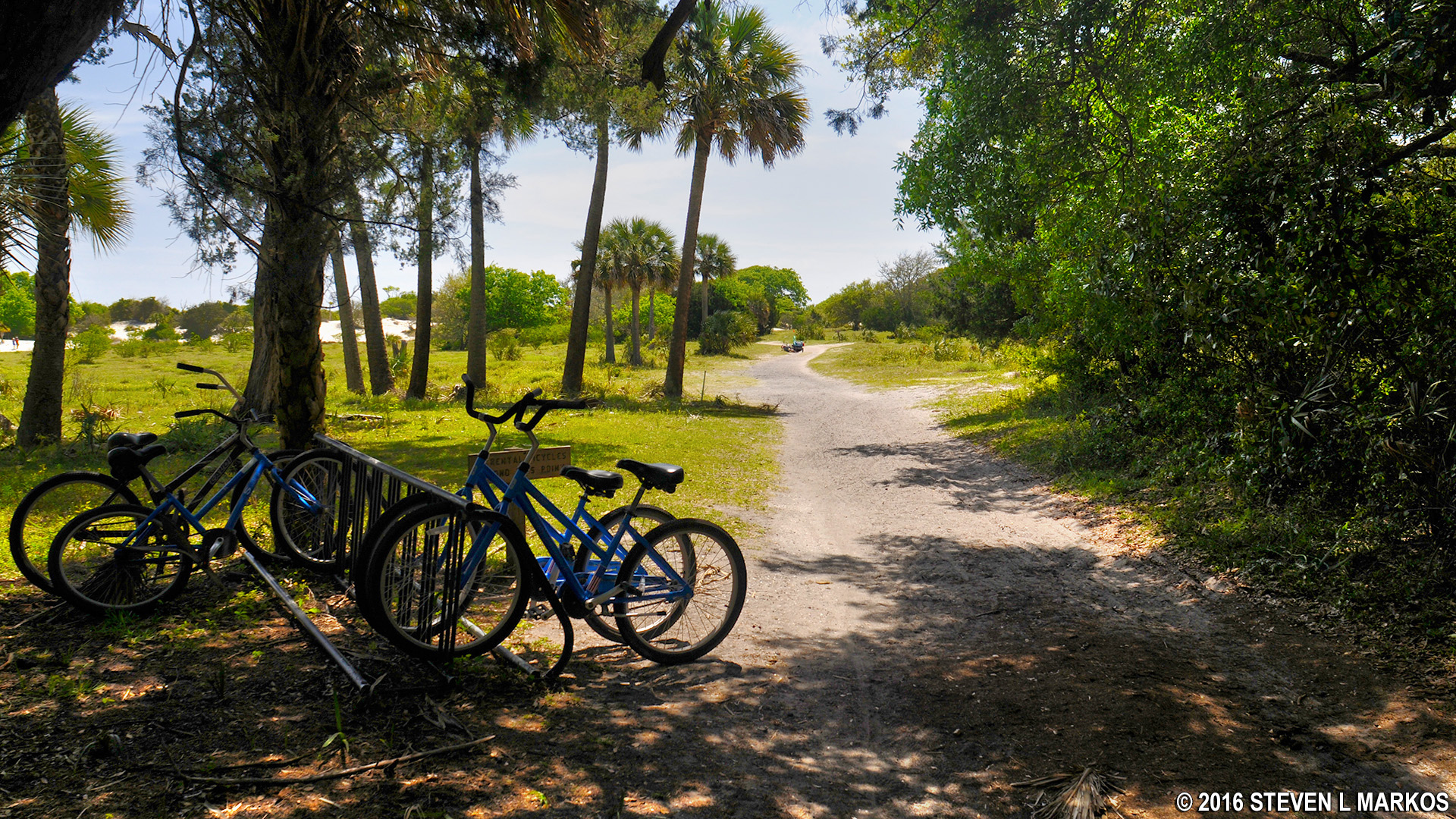
End of the road for rental bikes at Dungeness Beach, Cumberland Island National Seashore
The key to getting to the beach much easier than by taking the sandy road is to take a short detour on two boardwalks, both of which are off to the right. You must walk on the sand road for about 150 yards before coming to the first boardwalk. Look for the SALT MARSH sign and a wayside exhibit about the salt marsh on Cumberland Island.

Turn for the Salt Marsh Boardwalk at Cumberland Island National Seashore
Follow this path and you will come to a boardwalk that doubles as a nature exhibit, complete with spotting scopes and wayside exhibits. If you arrive at high tide, you are treated to nice views of the water; at low tide you pretty much have a view of mud, but you are more likely to see birds wading through the muck looking for food.

First boardwalk on the way to Dungeness Beach at Cumberland Island National Seashore

Marsh during high tide at Cumberland Island

Marsh during low tide at Cumberland Island

Observation deck and spotting scoops on Cumberland Island’s Salt Marsh Boardwalk
By the way, the foundation ruin you pass is the remnant of the Carnegie’s dairy barn.

Foundation of the Carnegie dairy barn near Dungeness Beach on Cumberland Island
Once you get to the end of the boardwalk you will be dumped out onto the sand dunes, and it is slow going for a while as you make your way back to the road. Signs pointing the way are sparse, but the route is fairly evident. Just follow the footprints left in the sand by everyone else who is going to the beach.

Sand dunes in between boardwalks on the walk to Dungeness Beach on Cumberland Island
Once back on the road, take a right and be on the lookout for the second boardwalk. Unlike the first that offers scenic views, this boardwalk is designed to make the trek to the beach easier for those on foot (I say “on foot” because permanent residents of Cumberland Island can drive the road to the beach, and even on the beach). The boardwalk also gets you out of the sun for a while because it cuts through a small maritime forest.

Second boardwalk on the walk to Dungeness Beach on Cumberland Island

Boardwalk near Dungeness Beach passes through a maritime forest on Cumberland Island
Unfortunately, the boardwalk does not go all of the way to the beach. While much of the final walk is along firmer packed sand, there is one stretch of dunes that you must cross before reaching Dungeness Beach.

Hard-packed sand trail near Dungeness Beach on Cumberland Island

Walk across the final stretch of sand dunes at Dungeness Beach on Cumberland Island
As far as beaches go on Cumberland Island, they are all of the same quality. The only difference is that the farther south you go, the wider the beaches get. At low tide Dungeness Beach is so wide that if you didn’t see the water you’d think you were walking in the desert. Other than that, which beach you visit depends on the effort you want to put forth. Common sense tells you that the farther you walk the less people you will encounter. However, only about 300 people come to Cumberland Island each day, and not everyone is going to the beach. Regardless of where you end up, you won’t run into mainland-size beach crowds.
Once on the beach, if you take a walk along the shoreline, keep in mind that you can only cross the sand dunes at paths marked with black-and-while posts. These were installed by the National Park Service to keep people from getting lost; be on the lookout for them. Any paths through the dunes without a marker are on private property.

Dungeness Beach at Cumberland Island National Seashore
If you want a nice walk along the beach, take the shoreline up to Sea Camp Beach, which is about 1.25 miles farther north. It is another .8 mile from the beach to the Sea Camp ferry dock. A loop from Dungeness dock to Sea Camp dock that includes a full tour of the Dungeness historic area and the beach walk is about five miles.

Walk from Dungeness Beach to Sea Camp Beach, Cumberland Island National Seashore
With a few exceptions, use of any photograph on the National Park Planner website requires a paid Royalty Free Editorial Use License or Commercial Use License. See the Photo Usage page for details.
Last updated on July 23, 2024


