

Marietta Paper Mill ruins on the east side of Sope Creek in the Cochran Shoals Unit of Chattahoochee River National Recreation Area
The most extensive historic ruins in the entire Chattahoochee River National Recreation Area are located in the Sope Creek section of the Cochran Shoals Unit: the Marietta Paper Mill ruins. The ruins are so extensive that they cover two sides of Sope Creek. The only other historic ruins in the Recreation Area are a couple of old bridges and two walls of a textile mill at the Vickery Creek unit. The ruins at Sope Creek make all of these non-events. Allow 1 to 1.5 hours to explore and photograph the ruins and to make the thirty-minute round-trip hike from the Soap Creek parking lot.
Begin your journey on the hiking trail located near the picnic area at the far end of the Sope Creek parking lot. To help with navigation, download the Sope Creek trail map (PDF) and carry a copy with you.

Start of the hiking trail at Sope Creek, part of the Cochran Shoals Unit of Chattahoochee River National Recreation Area
Take the hiking trail towards intersection SC 3 and then on to SC 4 (see map for intersection numbers). Take a left at SC 4—a very sharp left—to head in the direction of the Marietta Paper Mill ruins. The entire hike to the ruins is downhill, starting off on a gradual slope all the way to SC 26.
In less than 500 feet past SC 4 you will approach Paper Mill Road and arrive at an unmarked intersection. You have the choice of continuing straight to the road on a narrow, fading footpath or making a U-turn to the right on a more obvious hiking trail. Make the U-turn and proceed to the next intersection, SC 26. The trail runs along a ridge that follows the road.
Continue straight at SC 26, down a much steeper trail that leads directly to the road, then follow the path that runs to the right of the guard rail to reach the paper mill ruins on the west side of Sope Creek. It’s a fifteen minute hike to the ruins from the parking lot.

Intersection SC 26 on the Sope Creek trails, part of the Cochran Shoals Unit of Chattahoochee River National Recreation Area
The Marietta Paper Mills were built in 1859 and remained in operation throughout most of the Civil War. On July 5, 1864, the mills, which manufactured paper for Confederate money among other products, were burned by Union troops in pursuit of the Confederate army as it retreated from Kennesaw Mountain. The mills were rebuilt after the war, but burned down again in 1870. After being rebuilt one more time, they produced newsprint and other paper products until 1902.

Marietta Paper Mill ruins at Sope Creek, part of the Cochran Shoals Unit of Chattahoochee River National Recreation Area
Photos from the 1950s show the old buildings largely intact, missing only their roofs and windows, but all that remains today are some of the walls. Even so, an extensive amount of standing structure remains. You can actually walk inside the ruins here on the west side of Sope Creek, though you may find it overgrown with vegetation during the summer. A hundred years from now there may be no sign of the former buildings other than piles of river stones.
Marietta Paper Mill ruins at Sope Creek during the winter, Chattahoochee River National Recreation Area

Outer wall of the Marietta Paper Mill ruins facing Sope Creek, Chattahoochee River National Recreation Area

Outer wall of the Marietta Paper Mill ruins facing Sope Creek, Chattahoochee River National Recreation Area

Left corner of a building that was part of the Marietta Paper Mill on Sope Creek in Chattahoochee River National Recreation Area

View from interior of a building that was part of the Marietta Paper Mill through a window overlooking Sope Creek, Chattahoochee River National Recreation Area
When studying the ruins, pay attention to two things. First, look between the stones and you can still see the sand that was originally shoved in the cracks to form a type of mortar to hold the stones together.

Original sand mortar that held together the stone walls of a building that was part of the Marietta Paper Mill on Sope Creek in Chattahoochee River National Recreation Area
Second, take a look at the wooden beams that form the top of each window and door. They look far from being 100-plus years old. Some even look brand new. I tried to figure out how these could have been replaced with modern wood, but I just could not fathom it. Some beams are holding up an entire wall above them; pull these beams out and the wall collapses. If this is a reconstruction, then it just dumbfounds me as to how it was done. If not, then that’s some well-preserved wood. I know the National Park Service does reconstruction to historical properties, but we’re talking about places like Fort Sumter—places people actually pay money to see—not some half crumbed paper mill in the middle of the woods. If these walls were in danger of collapse, I would imagine they would have been torn down or placed off limits to the public, not fixed.

Support beams for a window in a building that was once part of the Marietta Paper Mill on Sope Creek in Chattahoochee River National Recreation Area
Once done exploring the ruins on the west side of Sope Creek, take a look at your trail map and you will see a fairly long out-and-back trail that runs along the other side of of the creek. This is where the bulk of the paper mill ruins are located. To get there, walk back to the road (SC 27) and cross the vehicle bridge. The original bridge over Sope Creek was a wooden, covered bridge until 1964. Its stone foundations can be seen under the new, modern bridge.
When you reach the other side of Sope Creek, take a right and head down a short, dirt road that is blocked off to vehicles by a gate (SC 28). Beyond the gate, the path becomes a traditional hiking trail that leads to the mill ruins on the east side of the creek. Most hikers do not know these ruins exist, so the trail is lightly traveled and may be a little overgrown in spots. When walking, look down towards the right edge of the trail and you can see the top of the stone retaining wall that supports it. This wall runs the entire length of the trail. At some places the wall is only a few feet tall, at others, twenty feet or more.

Stone retaining wall on the east side of Sope Creek supports a trail leading to the Marietta Paper Mill ruins in the Cochran Shoals unit of Chattahoochee River National Recreation Area
Ruins of the old mill start to appear just a few minutes down the trail and continue for its entire quarter-mile length. The first structure is a small building, nothing spectacular, perhaps an office.

Ruins of a small building on the east side of Sope Creek that was once part of the Marietta Paper Mill, Cochran Shoals Unit of Chattahoochee River National Recreation Area
Another five minute walk brings you high above rows of stone walls situated at the riverbank. I do not know what they were used for, but there is row after row of them, all about ten feet apart and parallel to each other. The stone walls jut from the retaining wall, which forms the back of the structures, while the fronts are open to the creek. If I had to guess, I’d say they were some sort of storage bins that once had wooden roofs on them. If the river were deep, they could pass for the support columns of a loading dock, but Sope Creek can be waded across by foot. With some effort, in certain places you can get down to the riverbank to explore the area further.

Stone walls along the Sope Creek riverbank were once part of the Marietta Paper Mill, Cochran Shoals Unit of Chattahoochee River National Recreation Area

Frontal view of stone walls along the Sope Creek riverbank that were once part of the Marietta Paper Mill, Cochran Shoals Unit of Chattahoochee River National Recreation Area
It is within eyesight of these stone “storage bins” that the crux of the mill is located. This massive structure was made up of many rooms and was two to three stories tall. On the trail, you are standing at the second story level, with the first floor at river level. There is no way to enter the buildings from the trail without risking serious injury, as you are basically looking down from the second floor to the bottom level. There are no floors or roofs remaining.

Interior of one room in the main building of the former Marietta Paper Mill on Sope Creek, Cochran Shoals Unit of Chattahoochee River National Recreation Area

Interior wall of the main building of the former Marietta Paper Mill on Sope Creek, Cochran Shoals Unit of Chattahoochee River National Recreation Area

A view through a window or door to the lower floor of the main building of the former Marietta Paper Mill on Sope Creek, Cochran Shoals Unit of Chattahoochee River National Recreation Area

Ruins of the main building of the former Marietta Paper Mill on Sope Creek, Cochran Shoals Unit of Chattahoochee River National Recreation Area

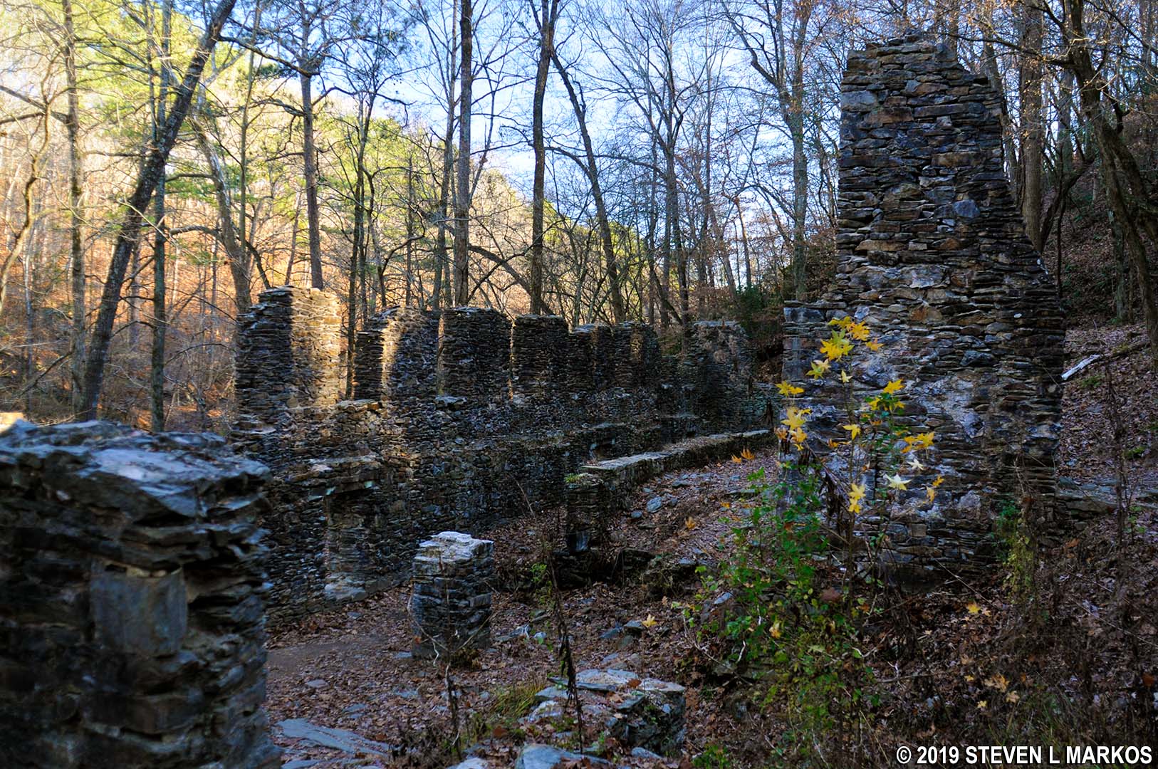
Marietta Paper Mill ruins on the east side of Sope Creek, Cochran Shoals Unit of Chattahoochee River National Recreation Area
The outer walls are exposed river stone, as expected, and most of the inner walls are exposed stone as well. However, there is one inner wall that is coated with some sort of cement or plaster, giving it the look of a typical finished interior wall. Most likely all of the interior walls were once finished like this when the mill was first built, but the plaster has since been chipped away.

Plaster covered interior wall of a building that was once part of the Marietta Paper Mill on the east side of Sope Creek, Cochran Shoals Unit of Chattahoochee River National Recreation Area
Looking at the entire project, all built with what appears to be river stones from Sope Creek and the surrounding area, it hurts just thinking about the labor it took to build this place—supposedly all slave labor. While it isn’t an Egyptian pyramid, it was definitely an undertaking. The mills were made of so many river stones—the walls are two feet thick—that it is hard to imagine that there are any stones left in the creek at all, yet Sope Creek is full of them.

Plenty of river stones left in Sope Creek, Chattahoochee River National Recreation Area
The trail ends at Caney Creek, but there are some more buildings on the other side. You can’t get there from here unless you wade across the knee-deep creek or follow the creek inland up a hill until you find a shallower spot to cross. There is no inland trail, so you may have to bushwhack your way during the summer, and there is poison ivy and ticks in the area. Also, there is a golf course at the top of the hill. Needless to say, I did not attempt to cross the creek or hike inland.

Ruins of the Marietta Paper Mill end at the narrow Caney Creek, Cochran Shoals Unit of Chattahoochee River National Recreation Area

End of the Marietta Paper Mill ruins at the confluence of Caney Creek and Sope Creek in the Cochran Shoals Unit of Chattahoochee River National Recreation Area
After exploring the ruins, walk back to the road and cross the bridge to reenter the main section of the park. If you would like to hike the Sope Creek area, try my suggested 3.6-mile loop hike. Information is on the Sope Creek Hiking Trail page.
With a few exceptions, use of any photograph on the National Park Planner website requires a paid Royalty Free Editorial Use License or Commercial Use License. See the Photo Usage page for details.
Last updated on May 7, 2024


