

Sope Creek Hike (click to enlarge)
Sope Creek Loop Hike
Length: 3.6-mile loop
Time: 2.5 hours, including time to explore the Marietta Paper Mill ruins
Difficulty: Moderate with some periodic, very strenuous inclines
Download the Sope Creek Trail Map (PDF)
The trails at Sope Creek (pronounced “soap”) are forested trails that flow up and down small hills. The trail surface is mainly smooth, but there are sections with roots and rocks to trip over. The canopy of the trees keeps out much of the sun, allowing for bearable summertime hikes. The trails cross a diverse water-based landscape, with rivers, creeks, streams, and a pond, plus historic ruins, which makes this one of the more interesting hikes in Chattahoochee River National Recreation Area.
There are two trailheads located at the far end of the Sope Creek parking lot. The impossible-to-miss, wide-as-a-road path is the bike trail. The hiking trail is to the left near the picnic area. My loop hike proceeds in a clockwise direction, starting on the hiking trail and returning on the bike trail. I recommend this direction because you’ll get more downhill hiking than uphill.

Start of the hiking trail at the Sope Creek section of Chattahoochee River National Recreation Area

Start of the biking trail at the Sope Creek section of Chattahoochee River National Recreation Area
Begin the hike by traveling towards intersection SC 3 and then on to SC 4 (see map for intersection numbers). Take a left at SC 4—a very sharp left—to head in the direction of the Marietta Paper Mill ruins. The entire hike to the ruins is downhill, starting off on a gradual slope all the way to SC 26.
In less than 500 feet past SC 4 you will approach Paper Mill Road and arrive at an unmarked intersection. You have the choice of continuing straight to the road on a narrow, fading footpath or making a U-turn to the right on a more obvious hiking trail. Make the U-turn and proceed to the next intersection, SC 26. The trail runs along a ridge that follows the road.
At SC 26, take notice of the trail that proceeds uphill to your right. After exploring the Marietta Paper Mill ruins, you will return here and take this trail to continue the loop hike around the Sope Creek area. For now, continue straight, down a much steeper trail that leads directly to the road, then follow the path that runs to the right of the guard rail to reach the paper mill ruins on the west side of Sope Creek. It’s a fifteen minute hike to the ruins from the parking lot.

Intersection SC 26 on the trails in the Sope Creek section of Chattahoochee River National Recreation Area
The extensive ruins before you are only part of the former Marietta Paper Mill. For complete information about the mill, as well has plenty of photos, visit the Cochran Shoals Historic Ruins web page here on National Park Planner.

Marietta Paper Mill ruins at Sope Creek, Chattahoochee River National Recreation Area
Marietta Paper Mill ruins at Sope Creek, Chattahoochee River National Recreation Area
In addition to exploring the ruins, you are treated to views of the very photogenic Sope Creek. The stones from the river were undoubtedly used to build the mill.

Sope Creek at the Marietta Paper Company mill ruins, Chattahoochee River National Recreation Area
If you take a look at the trail map, you will see a fairly long out-and-back trail that runs along the other side of Sope Creek. This is where the bulk of the paper mill ruins are located. To get there, walk back to the road (SC 27) and cross the vehicle bridge. The original bridge over Sope Creek was a wooden covered bridge until 1964. Its stone foundations can be seen under the new, modern bridge.
When you reach the other side of Sope Creek, take a right and head down a short, dirt road that is blocked off to vehicles by a gate (SC 28). Beyond the gate, the path becomes a traditional hiking trail that leads to the mill ruins on the east side of the creek. Most hikers do not know these ruins exist, so the trail is lightly traveled and becomes a little overgrown in spots. When walking, look down towards the right edge of the trail and you can see the top of the stone retaining wall that supports it. At some places the wall is only a few feet tall, at others, twenty feet or more.

Stone retaining wall supports a trail leading to the Marietta Paper Mill ruins on Sope Creek, Chattahoochee River National Recreation Area
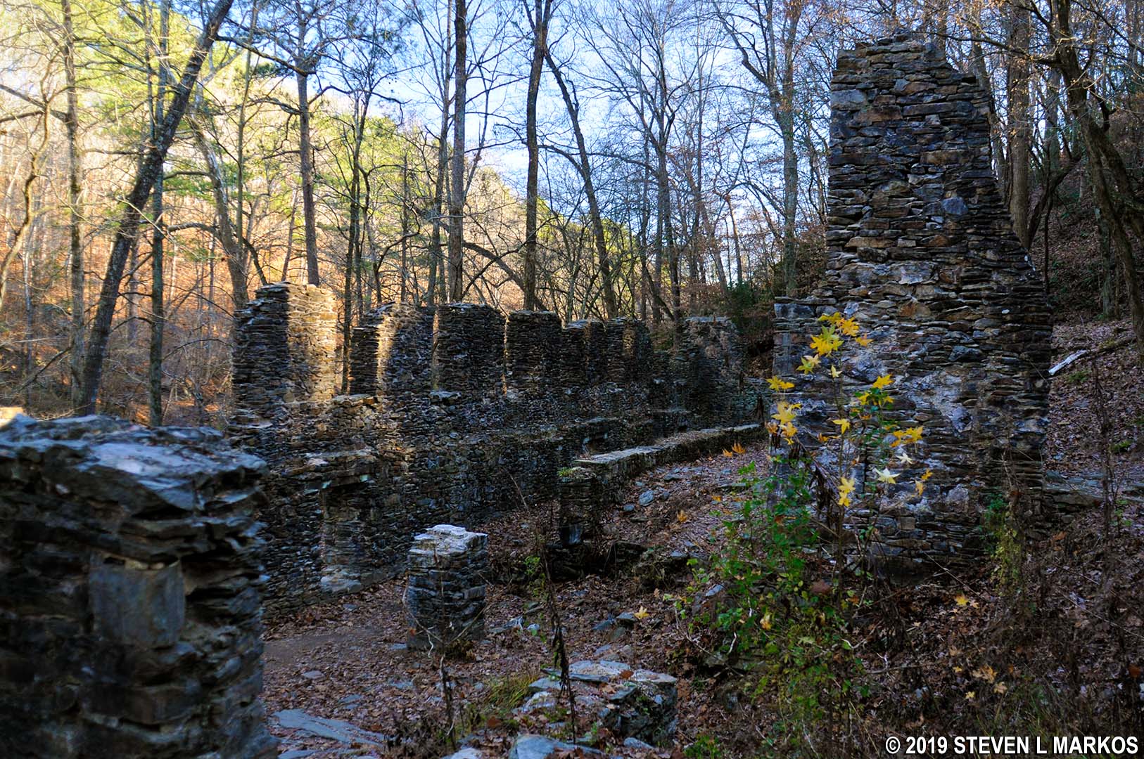
Ruins of the old mill start to appear just a few minutes down the trail and continue for its entire quarter-mile length. Structures include what appear to be storage bins, small buildings, and a massive factory.

Marietta Paper Mill ruins on the east side of Sope Creek in Chattahoochee River National Recreation Area

Marietta Paper Mill ruins on the east side of Sope Creek in Chattahoochee River National Recreation Area
The trail ends at Caney Creek, but there are some more buildings on the other side. You can’t get there from here unless you wade across the knee-deep creek or follow the creek inland up a hill until you find a shallower spot to cross. There is no inland trail, so you may have to bushwhack your way during the summer, and there is poison ivy in the area. Also, there is a golf course at the top of the hill. Needless to say, I did not attempt to cross the creek or hike inland.

End of the Marietta Paper Company factory building at Caney Creek, Chattahoochee River National Recreation Area
After exploring the ruins, walk back to the road and cross the bridge to reenter the main section of the park. Hike back the way you came until you reach SC 26, then continue left up the hill towards SC 6. In the fall you can see the west-side mill ruins from the ridge you are walking on, but in the summer you won’t be able to see anything but trees.
After a short distance the trail forks—save yourself some time and stay right, as the trail to the left just swoops downhill a little ways before working its way back up to reconnect with the trail you are on. You will see a blue paint splotch on a tree along the trail to the right. These are called blazes, and they are used to mark trails like Hansel and Gretel breadcrumbs. As a general rule, if you come to an unmarked intersection, head in the direction of the blue blaze, if one exists.

Example of a blue blaze on the Sope Creek trails in Chattahoochee River National Recreation Area
A little farther ahead is a very confusing, unmarked intersection. The landmark to look for is the massive trunk of two trees that grew together to form a V-shape. About twenty feet up the tree ends, having been snapped in two long ago. The trail continues straight to SC 30, or you can make what amounts to nearly a U-turn to the left. Make the U-turn to continue to SC 6. This is essentially a shortcut to SC 6 (vs. hiking to SC 30 first). You will be heading downhill until you reach the intersection.
When you get to SC 6, if you keep walking straight you will be on a short, out-and-back trail that leads to Sope Creek. I took this trail to get some more photos (ten-minute round trip), but unless seeing Sope Creek one more time is important to you, skip this detour. The trail you want to take is located directly behind you when looking at the trail map stand. This leads to intersection SC 7 and often follows a small stream that begins at Sibley Pond and feeds into Sope Creek.

Trail between intersection SC 6 and SC 7 in the Sope Creek section of Chattahoochee River National Recreation Area sometimes follows a small creek
SC 7 comes 1.75 miles into the hike. Take a left and proceed downhill—pretty steep—all the way until the intersection with the bike trail at SC 8. There are a lot of roots on the trail, so be careful not to trip or twist an ankle.
The section of the bike trail between SC 8 and SC 9 is rated as intermediate as far as biking is concerned, but for hikers it is no different than the hiking trails you’ve already been on. It is hilly and runs along a ridge that must be a couple hundred feet above Sope Creek, but other than tire tracks and two bikers who came by, I wouldn’t know the difference between this segment and any of the hikers-only trails at Sope Creek. Your main concern is to avoid getting run over by bikers, so be sure to keep a firm hand on little children and take your earbuds and headphones off so you can hear if somebody is coming. Unfortunately, at least half the trails at Sope Creek are open to bikers, so you can’t make a lengthy hike without walking on a bike trail at some point.

Bike trail between intersections SC 8 and SC 9 in the Sope Creek section of Chattahoochee River National Recreation Area
When you get onto the bike trail at SC 8, take a left towards SC 9. The distance between the two intersections is .4 mile, so it is one of the longer segments on the hike. When I visited the park, the SC 9 trail map stand was missing, and if this is the case when you hike the trail, just keep walking straight until you come to the second intersection, SC 25, another .3 mile ahead. You can’t miss the intersections of bike and pedestrian trails because they all have gates with NO BIKES written on them.

Typical intersection of a hiking and a biking trail in the Sope Creek section of Chattahoochee River National Recreation Area
When you reach SC 25, take a right to get off the bike trail and back onto the hikers-only trail. You could elect to hike a longer loop by staying straight at SC 25 until coming to SC 24, then continuing to SC 23 and SC 19, following the bike trail the entire way. During the week this might be fine, but there may be too many bikers on the trail on a nice, sunny weekend, so limiting time on the bike trails is a good safety measure.
At intersection SC 25, 2.5 miles into the hike, good times come to an end. I mentioned earlier that the clockwise hike is the best way to go because the trail has more level or downhill sections than uphill sections, and up to this point only a half mile of the 2.5 miles is uphill. But as you may have guessed, if you walk downhill, to get back to your starting point you eventually have to walk uphill for some distance. Well, uphill starts here…and I’m talking straight up! For nearly 500 feet the trail ascends on an average grade of 18% (strenuous hiking begins at 15%). Overall, you have a quarter mile of hiking before the trail eventually reaches the peak, and during this time you will have climbed 130 feet in elevation. For the record, only about 1 mile of the 3.6-mile hike is uphill when you travel in the clockwise direction.

Uphill climb from intersection SC 25 on the Sope Creek trails in Chattahoochee River National Recreation Area
On the way to SC 22 is another unmarked intersection where the trail dead ends into a T. I thought I had reached SC 22 and thus took a right towards my next intended destination, SC 21. While taking a right ended up being the correct move, the decision was just a matter of luck. There is a blue blaze on a tree to the right, but again, I turned because I thought I was already at SC 22, not because of the blaze. I have no idea where the left turn leads.
From SC 22 through the next four intersections—SC 21, 20, 19, and 18—the trail is straightforward. From SC 18, the next destination is SC 16. You can get there by taking a right and passing through SC 17, or you can add extra distance to your hike by taking a left and making a large half-circle hike to SC 16. Do yourself a favor and head to Sibley Pond via SC 17 because there’s nothing worth seeing on the longer route. There are also two intersections that are not even on the trail map, so you will just end up confused.

Sibley Pond in the Sope Creek section of Chattahoochee River National Recreation Area
At Sibley Pond I spent a few minutes photographing turtles on a branch in the water. There was also a HUGE turtle on a log near the shore, and this guy didn’t give a damn about anything. While all the other turtles high-tailed it into the water when I got near, he didn’t budge. I thought he was dead until I tossed a pine cone that splashed the water next to him. This got him into the water lickety-split.

Turtles sunning on a log at Sibley Pond in the Sope Creek section of Chattahoochee River National Recreation Area

Snapping turtle (?) on a log at Sibley Pond in the Sope Creek section of Chattahoochee River National Recreation Area
Just past the pond is the intersection (SC 15) with the bike trail that you saw at the start of the hike. Take a left and you will soon be back at your car.
The hike at Sope Creek is a quality one. The only thing missing is the Chattahoochee River itself, but Sope Creek is easily its picturesque match. Overall, it’s one of the better hikes in Chattahoochee River National Recreation Area.
With a few exceptions, use of any photograph on the National Park Planner website requires a paid Royalty Free Editorial Use License or Commercial Use License. See the Photo Usage page for details.
Last updated on May 24, 2024


