
Florida Trail Loop Hike (click to enlarge)
See the Hiking web page for an interactive location map and information on required backcountry permits.
This hike was done during the dry season (winter). During the summer the area may be underwater or at least very muddy.
Length: 6.2-mile loop
Time: 3.5 hours
Difficulty: ★☆☆☆☆
The Florida Trail runs north to south through Florida for 1,300 miles, with its southern terminus being the Oasis Visitor Center at Big Cypress National Preserve. Obviously I did not hike the entire trail, but I did hike a short portion north of I-75 where a nice loop of about six miles in length can be formed. The only other possible loop hike is just north of the Oasis Visitor Center, but it is around 16 miles long. You will be exposed to the sun for the majority of the time, so wear a hat and apply sunscreen if avoiding sun damage is important to you.
I can’t speak for the rest of the Florida Trail, but the section I hiked was by far the best hike I did at Big Cypress National Preserve. I saw birds, alligators, and even heard a rattlesnake—didn’t stick around long enough to see it. This is also panther country, and though I did not spot one, I did run across a skeleton of what may have been one of its meals. If you have time for one hike, this is the one I recommend. In truth, none of the other hiker-only trails at Big Cypress are worth your time.
Parking for the trail is at the I-75 rest area at Mile Marker 63. The northbound trailhead is accessed from the westbound lane, but even if you are traveling east you can still exit and take an access road under the Interstate that leads to the other side. The parking lot is massive, and I can’t imagine a time when it would be full. The trailhead is located at the far right side, and a fence keeps unauthorized vehicles off the trail. No bikes are allowed either—hikers only.

I-75 rest area parking for the northbound Florida Trail trailhead at Big Cypress National Preserve

Northbound trailhead for the Florida Trail at Big Cypress National Preserve
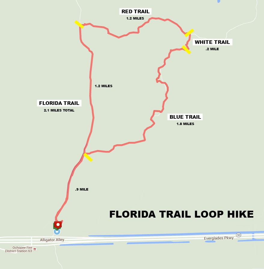
The first leg of the hike follows the Florida Trail for 2.1 miles. It starts off as a dirt road and forks after only a few minutes of walking—stay to the left. A sign indicates distances to the Blue, Red, and Yellow Trails, plus the Noble Campsite. The destination of this hike is the Red Trail.

Typical terrain of the Florida Trail at Big Cypress National Preserve
The entire hike along the Florida Trail follows a canal, and you can see many birds and alligators. There is a lot of brush between you and the water, but there are plenty of spots where people have beaten paths to the canal, so it is possible to get a good view of the wildlife.

Canal along the Florida Trail at Big Cypress National Preserve
Any alligators that are on the same side of the canal as you are will splash into the water and head to the safety of the other side long before you get to them, or they will simply disappear under the water and remain there until you have left. However, gators that are already sunning themselves on the other side won’t go anywhere, and these are the ones you can get a good look at. Keep a sharp eye on the canal to spot them.

Alligator along the Florida Trail canal at Big Cypress National Preserve

Alligator along the Florida Trail at Big Cypress National Preserve
You can’t go twenty feet without seeing a bird, but most fly away before you can get a good look at them. It’s hard not to make noise when walking down a dirt road. I felt like I had an invisible force field around me that sent birds flying away whenever I got to within 300 feet of them. However, there were a few high up in the trees that didn’t fly off, and like the alligators, some birds on the far side of the canal felt safe enough to continue rooting around in the muck looking for a meal.

Wood Stork in the canal on the Florida Trail at Big Cypress National Preserve

Egret along the Florida Trail at Big Cypress National Preserve

Wood stork in a tree along the Florida Trail at Big Cypress National Preserve

Zebra butterfly on the Florida Trail at Big Cypress National Preserve
The intersection with the Blue Trail comes about .9 mile into the hike. This marks the start of the loop. You could take a right on the Blue Trail and hike the loop in a counterclockwise direction, but I opted to stay straight on the Florida Trail and delay venturing away from the canal until coming to the Red Trail another 1.2 miles farther up the road. The Blue, Red, and other trails turn away from the canal, and I wanted to get all of my wildlife photos at one time.
The Red Trail intersection comes 2.1 miles from the start of the hike. This is where you want to turn off of the Florida Trail and head into the wilderness comprised of prairie, pine forest, and palmetto thickets. Many of these side trails are still roads, but they aren’t nearly as well worn as the Florida Trail. No swamp buggies or other vehicles are allowed in this area, so all of these trails were blazed prior to 1988 when this section, known as the Addition Backcountry Unit, or Addition Lands, was added to the park. Debate and threats of lawsuits leave the future of the Addition Lands up in the air. Conservationists want vehicles banned, while sportsmen argue that the park was created to preserve traditional outdoor activities, which include access to the land by swamp buggies and ATVs. With that said, you will find fresh tire tracks on these trails, but these are from the park Rangers and scientists who are studying the panthers and other animals in the area.

Typical terrain of the Red Trail at Big Cypress National Preserve
It is at this point that you leave the canal and the water-loving animals behind. You may still find animals as you travel east, but animals in this area are ones you’d rather not run into—bears, panthers, wild boars, and rattlesnakes. I had previously gone on a swamp buggy tour, and I learned that panthers like to live in the palmetto bush thickets, which is exactly the type of brush that lines much of the Red and other side trails. The panthers like these because the palm fronds make a huge racket whenever anything brushes up against them, which warns them that either danger or a meal is approaching. Had I not known this, I would have hiked the trail in an ignorant bliss. Instead, I expected to get pounced on at every turn. I even came upon a skeleton of a dead animal, very likely a former panther meal. Would the next hiker find my bones?

Bones of a possible panther meal on the Red Trail at Big Cypress National Preserve
Trees along the side trails are marked with blazes (paint splotches) that correspond to the trail names. In the case of the Red Trail you will find red blazes on the trees. However, they are not frequent enough to rely on for navigation, but you really don’t need them because there aren’t any side trails to throw you off track, and all of the intersections are well marked.

Red blaze on a tree along the Red Trail at Big Cypress National Preserve
Despite being February, a month that is well into the dry season, there was a decent amount of mud on some of the trails. Often you could walk around it, but other times the sharp, saw-tooth palmetto bushes hugged the trail too closely and you had to walk through the mud. Thus, either wear some hiking boots or shoes that you don’t mind getting muddy.

Mud still on the Red Trail in February at Big Cypress National Preserve
Towards the end of the Red Trail, about 3 miles into the hike, the terrain turns into a grassland, and it is here that I heard my first rattlesnake (in my life, not just in Big Cypress). I did not stick around to see it, but instead took off extra fast when I heard its rattle somewhere in the grassy area.

Grassland along the Red Trail at Big Cypress National Preserve
The next intersection is with the White Trail. Things get a little tricky because the trail map on the park brochure is not entirely accurate, or at least not large enough to show the turns in detail. The map makes it appear as if you will 1) pass a campsite when on the Red Trail, which does not happen, and 2) simply take a right at the next intersection in order to get back to the Florida Trail. While this is in theory correct, you actually must take rights on two different trails, the first one being the White Trail. There is a sign at the intersection.
The White Trail is a true hiking trail, not a road. It is narrow and grassy, and after running into the rattlesnake moments earlier, I was a little leery of walking down this trail. However, it is very short—only .2 mile long—and connects the Red and Blue Trails together.

Typical terrain of the White Trail at Big Cypress National Preserve
By the time I reached the Blue Trail five minutes later (3.5 miles into the hike) I was completely disoriented. Luckily you don’t really need to understand where you are in the scheme of things because the intersection is well marked. To get back to the parking lot, take a right in the direction of “Carpenter Camp (.2 mile) and the I-75 Gate via Blue Trail and FNST (2.7 miles).” A sign points the way.

Trail sign at the Blue Trail intersection at Big Cypress National Preserve
The Blue Trail is also a true hiking trail, but this one combines both the dense palmetto thickets and pine trees (panthers) with the grasslands (rattlesnakes), so it invokes a double amount of paranoia. Parts of this trail are by far the most claustrophobic that you will encounter on the hike, and at times you might label them as “overgrown.”

Start of the Blue Trail at Big Cypress National Preserve
The guide on my swamp buggy tour said that the water moccasins and coral snakes usually bite low and that hiking boots offer decent protection, but that the rattlesnakes can jump up high and bite above the protected boot area. The guys who spend a lot of time in the backcountry wear waterproof boots that come up to their knees, mainly for walking in the water, but also as protection against snake bites.

Swamp boots
Camp Carpenter is just a few minutes down the trail. You will find evidence of camping along the Blue Trail, but the actual campground is down an unmarked side trail (there is a Blue Trail sign at this intersection, but nothing indicates that the side trail leads to the campground). The campsite is nothing but a large clearing where the grass has been matted down over time by the various people who have camped here, plus there are a number of personalized alcoves that people have created by beating a path into the brush to get away from the main area. Camping is allowed anywhere in the Addition Backcountry Unit as long as you are at least a half mile from any developed area or road, but the designated campsites offer the convenience of a clearing, versus plopping a tent down in tall grass. The only sign of the modern world is a metal fire ring. There are no outhouses or other amenities. For more information on camping in the backcountry see the Backcountry Camping web page here on National Park Planner.

A side trail off of the Blue Trail leads to Camp Carpenter at Big Cypress National Preserve

Camp Carpenter near the Blue Trail at Big Cypress National Preserve
There are a number of side trails leading to other camping spots once you get to the Camp Carpenter area, so to ensure you stay on the correct trail, look for the Blue blazes painted on the trees. They appear a little more frequently than blazes on the other trails. This may be due to the fact that the Blue Trail is the most overgrown of the trails in the area. There are plenty of times when you begin to wonder if you are still on a trail at all, so keep an eye out for the blazes.

Blue blazes mark the Blue Trail at Big Cypress National Preserve
The pine trees and palmettos get so thick along the Blue Trail that parts of it are like walking in the jungle. You do not want to see a panther here. You want to see a panther in an open area where it crosses the trail way up ahead of you, not in an enclosed area were you have no chance to escape. I got the feeling that this is where they catch things to eat. It reminded me of the scene in the film Apocalypse Now when the tiger jumps out of the bushes and startles Captain Willard and Chef. However, no panther attacks have ever occurred in Big Cypress, though panthers have attacked people in other parts of the country. It wouldn’t be a bad idea to carry a can of bear spray with you on this hike.

Pine and palmetto thicket along the Blue Trail at Big Cypress National Preserve
You will come to another intersection marked by a post painted with a double blue blaze, which indicates a sharp turn. You can go left or right, but unfortunately there is no indication as to which is the correct way to turn unless you know how to read the blazes. The markings are on the side facing you and on the right side, indicating a right hand turn. I also had a GPS, and I could see that a right turn led back towards the parking area.

Sharp turn on the Blue Trail at Big Cypress National Preserve
At this point the trail widens, and based on the fresh tire tracks, it appears to see frequent ATV use. If you look carefully, you will spot a couple of motion sensor cameras used to photograph animals as they walk by. I saw the device and had no idea what it was until I bent down to give it a good look. The National Park Service now has a large photo of my face. It would be funny for a good-looking girl to take off her clothes and walk past it just to see how quickly the Rangers get out there to do some “research.”

Motion sensor camera on the Blue Trail at Big Cypress National Preserve
The Blue Trail eventually connects back to the Florida Trail at the 5.3-mile mark on the hike. This is the original intersection that you came to when you first started. Take a left to get back to the parking lot, another .9-mile walk that retraces the original route. You’ll get a second opportunity to see birds and alligators along the canal. The birds won’t be as abundant in the afternoon as they were in the morning, but alligators are more likely to be spotted since they like to sun themselves along the bank of the canal.
The hike ended up being a little over six miles long and it took me about 3.5 hours, though I probably spent a good half hour taking photos. As mentioned at the start of this review, this is the only opportunity for a short loop hike in the park, and it is the best hike that I did. The terrain varies widely and you get to see a number of environments—prairie-like grasslands, jungle-like palmetto thickets, and pine forests. The canal provides plenty of opportunities to see animals. I highly recommend this hike and will even go so far as to recommend skipping all the others and just putting your time and effort into this one.
With a few exceptions, use of any photograph on the National Park Planner website requires a paid Royalty Free Editorial Use License or Commercial Use License. See the Photo Usage page for details.
Last updated on July 13, 2026


