

Miller Bridge Boat Ramp at Horseshoe Bend National Military Park
Small motorboats, canoes, kayaks, and other hand-paddled watercraft can be launched into the Tallapoosa River at the Miller Bridge Boat Ramp located on Highway 49. If at the Horseshoe Bend National Military Park Visitor Center, go back out to the highway and head west (to the left). Just after crossing over the river on Miller Bridge is a driveway on the right that leads to a picnic area and the park’s boat ramp.

Miller Bridge Boat Ramp is on the west side of the park (click to enlarge)
The water level of the river at this point is regulated by the release of water from the Harris Lake Dam, so high and low water levels can vary as much as four feet. There are many rocks at the boat ramp, and at low-water levels motorized boats will most likely have to be paddled over the rocks before the motor can be used. The favorable discharge rate is between 1,500 and 10,000 cubic feet per second. Lower than 1,500 and you’ll be dragging your boat over rocky shoals, and higher than 10,000 is considered dangerous. The optimal discharge rates occur most often between Memorial and Labor Day weekends as Alabama Power Company, which runs the dams, tries to keep Lake Martin at full pool. You can get the current discharge rates for Horseshoe Bend at https://waterdata.usgs.gov/nwis/uv?02414715. (You must scroll down on the page and choose Discharge instead of the default Gauge Height.)
The stone pillars that stand in the water just downstream of Miller Bridge were once the support columns for a covered bridge that spanned the Tallapoosa River. When in operation from 1908 until being replaced in the late 1950s, this was the longest covered bridge in the United States. The old bridge remained standing until being washed away by floodwaters in 1963.

Supports for a former bridge still stand in the Tallapoosa River next to the Miller Bridge Boat Ramp at Horseshoe Bend National Military Park
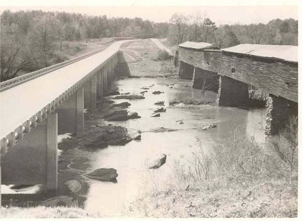
New Miller Bridge and the old covered bridge
The Miller Bridge Boat Ramp is very popular with canoeists and kayakers. The river is slow moving between Harris and Martin lakes, so the trip is suitable for paddlers and passengers of all ages (well, maybe not infants). To plan a trip, be sure to download the Horseshoe Bend Canoeing Guide here on National Park Planner. If you can stop at the Visitor Center first, there is a much better map available—it’s waterproof and free. You can also speak with a Ranger about different paddling options.

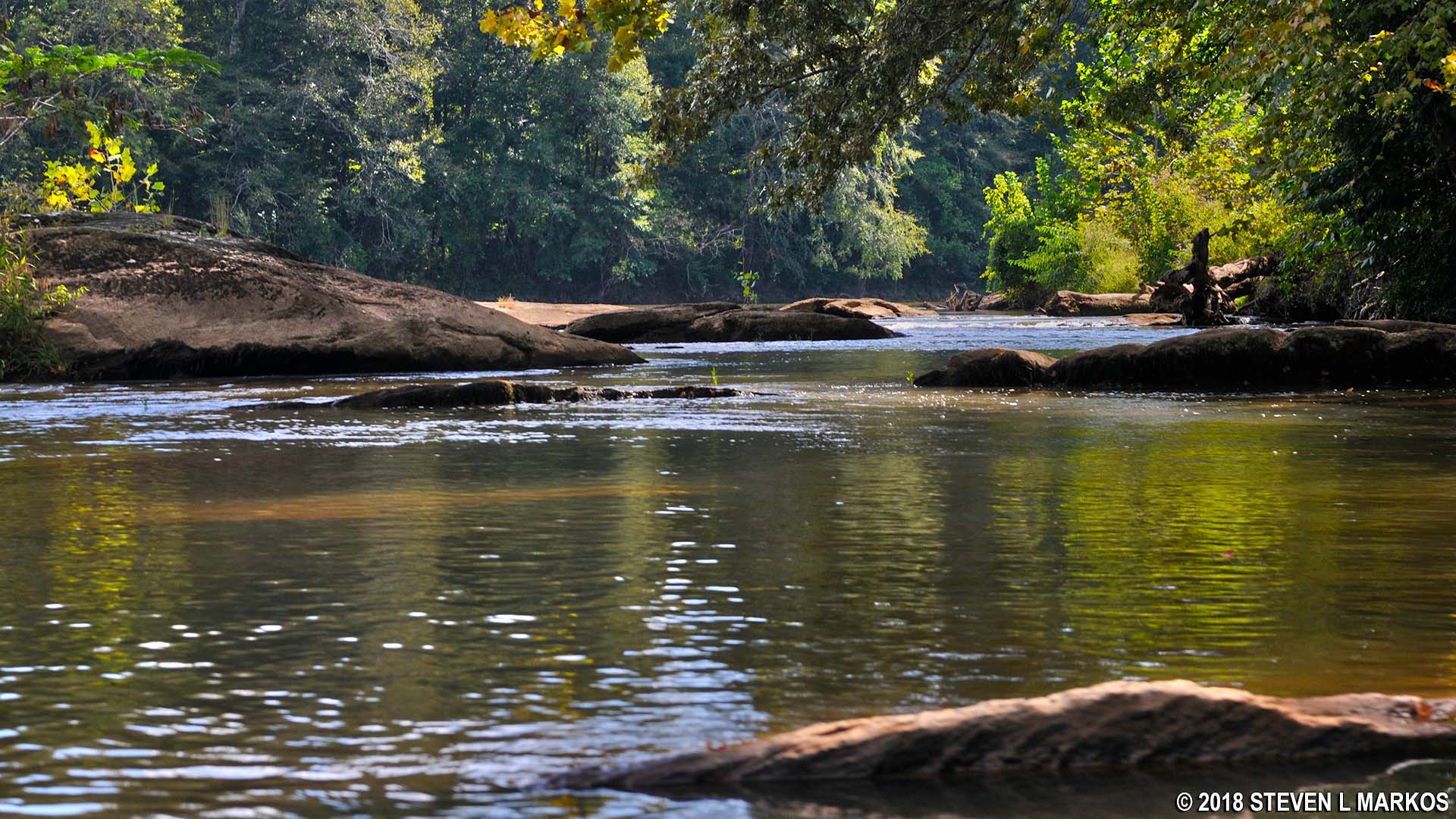
Tallapoosa River at Horseshoe Bend near Horseshoe Bend National Military Park
The Tallapoosa River runs from east to west, so if you launch from Miller Bridge and follow the current, you will be leaving Horseshoe Bend National Military Park and heading towards Lake Martin. The next public boat ramp is at Peters Island just 1.25 miles downriver, so most likely anyone launching from Miller Bridge will want to go farther. For most paddlers, a more logical takeout point is Jay Bird Landing, a trip of approximately six miles.
As a writer focusing on National Parks, I am much more interested in a trip that takes me through the park from east to west, passing around the peninsula that gives the park its Horseshoe Bend name. There are two options depending on if you have one or two vehicles, or a ride. If you have two vehicles or a ride waiting for you at the end, the preferred trip would be to launch from Germany’s Ferry and take out at Miller Bridge, a distance of approximately 9 miles. As for time, most anyone can paddle two miles an hour, and stronger paddlers can average three to four miles per hour. Thus, figure three hours if you are trying to set a speed record and up to five hours if traveling at a more leisurely pace.
The second option is to launch from Miller Bridge and paddle upriver around the peninsula to a desired point, then head back to the bridge. This is what I ultimately opted for, but somewhat regret. I stopped at the Visitor Center the day before my trip to discuss options with the Ranger. I had access to two vehicles, and my original plan was to launch from Germany’s Ferry and have a ride waiting for me at Miller Bridge. My family and I were camping at Wind Creek State Park on Lake Martin, and my wife was leaving around noon the next day (Sunday) so she could be back at work on Monday. I would do the trip on my own and time it so that she and my daughter, Sasha, could pick me up at Miller Bridge on her way back to Atlanta (Sasha was staying with me for another day of camping). That’s when the Ranger suggested paddling upriver, thus not having to bother with being picked up. He said there was some strong current when passing under the bridge, but it was manageable, and after that the river hardly moved, so that’s what I opted for. I stayed at the campground until my wife left, then Sasha and I drove the half hour to Miller Bridge and started our trip.
What sounded like a good idea wasn’t all that good. First off, when departing upriver from Miller Bridge you will be traveling around Bean’s Island, an island that was occupied by American troops under the command of Lieutenant Jesse Bean during the Battle of Horseshoe Bend. Bean and his men were there to keep the Red Sticks from retreating across the river. When many Indians did attempt this path of escape, they were shot dead. If you travel up the river along the west side of the island (immediate right from the boat ramp), you will have to get out and drag your boat across as many as three rocky shoals. Thus, the better way to go is up the east side (far side from the boat ramp), but depending on the water level, this may entail paddling against a very strong current that passes under the bridge. The higher the water—which is preferred when paddling—the stronger the current.

View of the Tallapoosa River from the Miller Bridge Boat Ramp at Horseshoe Bend National Military Park
No matter which route you ultimately must take, always try for the east side of the island. Unfortunately for me, I did the trip when the water was high and the current strong, and no matter how hard I paddled—and I am a strong paddler—I could not make it past the bridge to the east side of the island, and I tried three times. Now, I was in an inflatable two-man kayak which isn’t as easy to paddle as a hard, fiberglass boat, but most likely that wasn’t the problem. The more likely reason for my defeat is that I had my 12-year-old, 90-pound daughter in the front, and when you take a photo of a kid before departing on a big adventure and the kid has a cell phone in one hand, you probably won’t get much effort out of him or her. In fact, I got none, so I was essentially trying to paddle across a strong current with a large rock planted at the front of my boat. I’m not saying I would have made it without her, but carrying 90 pounds of dead weight didn’t help any.

Sasha preparing for a kayaking adventure on the Tallapoosa River, Horseshoe Bend National Military Park
I had no choice but to head up the west side of this island. Luckily the water was high enough that I could paddle over two of the rocky shoals, but Sasha and I did have to get out and drag our boat over the last one. This was actually a small adventure itself, so it was kind of fun, but I wouldn’t want to do it three times.
Rocky shoals on the west side of Bean’s Island, Horseshoe Bend National Military Park

Rocky shoal on the west side of Bean’s Island, Horseshoe Bend National Military Park
Once past the shoals, the Tallapoosa River is wide, deep, and calm. However, it is mentally draining to me knowing that perhaps a third of my effort is spent fighting a current, regardless of how slow. All I could think about was how pleasant this trip would be if I were traveling downriver. If you’ve ever felt like you were wasting time on a fruitless activity, that’s the way I feel about paddling against a current.
My original plan was to travel as far north around the east side of the Horseshoe Bend peninsula as the Miller Bridge Boat Ramp was on the west side. However, while I did get to the east side, I only made it halfway up before deciding to turn around. I just couldn’t bear paddling against the current any longer, and I doubt it was moving much more than a mile an hour. In fact, in some places if you stopped paddling, the boat sat still.
Another reason I turned around early was because the scenery never really changes, and we didn’t even see any wildlife. The Tallapoosa River in this area is simply lined with trees, and in truth, the trip eventually became a bore—and more so knowing that I had to turn around and see everything again. I’m not sure what the scenery is from where I stopped to Germany’s Ferry, but from satellite images, it looks to be just more of the same.

Tallapoosa River at Horseshoe Bend, Horseshoe Bend National Military Park
On the return trip you definitely want to take the fork in the river around the east side of Bean’s Island (right side). There are no shoals, and no matter where the strong current near the bridge takes you, once you pass underneath, it is an easy paddle to the boat ramp.

Miller Bridge and boat ramp as seen from the east side of Bean’s Island, Horseshoe Bend National Military Park
In all, I traveled three miles round trip and spent an hour and a half on the river. However, having Sasha in the boat, I’m glad I opted for this shorter route, because she would have been complaining the entire nine miles if I took the trip from Germany’s Ferry.
With a few exceptions, use of any photograph on the National Park Planner website requires a paid Royalty Free Editorial Use License or Commercial Use License. See the Photo Usage page for details.
Last updated on March 21, 2025


